
SARASOTA, Fla. (WWSB) – Trick or treat — this week’s forecast is serving up a rare Florida chill instead of the usual sticky Halloween heat. Two cold fronts are teaming up to bring back “baby fall” just in time for spooky season.
Big pattern shift ahead
A weak front slides through early this week, bringing a few scattered showers on Monday. By Tuesday, noticeably cooler and drier air begins filtering in behind the front.
A stronger cold front arrives Wednesday night, setting the stage for the coolest air so far this season as “baby fall” makes a strong return late week. Dew points will drop into the 50s, making Thursday and Friday mornings feel crisp and refreshing.
 A rare chill in the Sunocast this year for Halloween!(WWSB)A rare Halloween chill
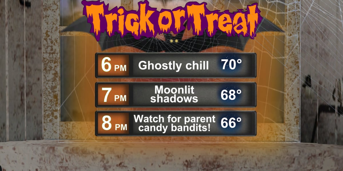
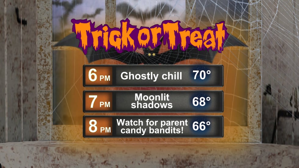
If the current forecast holds, Halloween 2025 could be one of the coolest on record for the Suncoast. Afternoon highs are expected to stay in the low to mid 70s with dew points in the 50s, and trick-or-treat temps in the mid 60s under clear skies and light breezes.
That’s a big shift from our usual warm and humid Halloween evenings. Since record keeping began, only about 8 percent of Halloweens in Sarasota have had both highs below 76 degrees and lows below 62. It’s the kind of crisp, fall-like weather more typical of Tennessee or the Carolinas than coastal Florida.
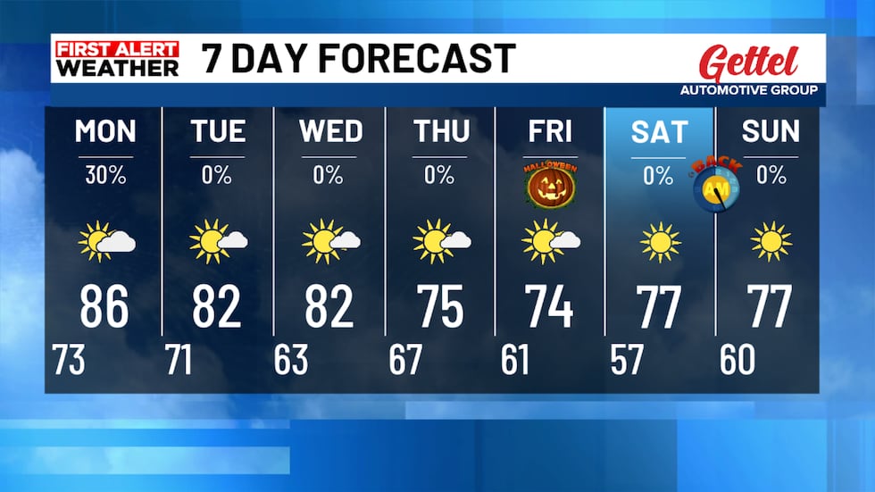 Cool weather arrives late week!(WWSB)7-day outlook (Suncoast)Monday: High 86 / Low 70 — 30% rain — partly sunny, a few inland storms.Tuesday: High 84 / Low 65 — 0% rain — sunny and less humid.Wednesday: High 82 / Low 67 — 0% rain — breezy with lower dew points.Thursday: High 77 / Low 62 — 0% rain — crisp and breezy.Friday: High 74 / Low 56 — 0% rain — coolest day of the season so far.Saturday: High 76 / Low 60 — sunny and comfortable.Sunday: High 77 / Low 61 — sunny and dry.
Costume planners are in for a treat this year. No sweat-soaked masks or sticky face paint, just pure sweater-weather vibes.
Sky tonight
A few spotty showers may linger this evening, but skies will gradually clear overnight. Temperatures drop into the lower 70s with a light breeze.
Once clouds thin out, Jupiter will shine bright next to the Moon again tonight, and it’s another great viewing night for the Orionid meteor shower, which remains active into the coming week. Peak activity has passed, but patient sky watchers can still spot several meteors per hour under dark skies after midnight.
Tropics update: Hurricane Melissa
Hurricane Melissa has rapidly intensified into a Category 4 hurricane in the Caribbean, with maximum winds near 145 mph. The storm is expected to move near or over Jamaica on Tuesday, then eastern Cuba Tuesday night, before moving toward the southeastern Bahamas.
Melissa poses no direct threat to Florida at this time, but it is a powerful and dangerous storm with life-threatening impacts expected for Jamaica and parts of Cuba.
Boating outlook
Marine conditions improve slightly Monday but turn gusty again midweek as the strong front approaches. Small Craft Advisories may be needed Thursday as northwest winds increase behind the front.
Copyright 2025 WWSB. All rights reserved.