
ORLANDO, Fla. – Melissa officially became a hurricane on Saturday and as of the 11 p.m. advisory from the National Hurricane Center, is now a Category 3 storm.
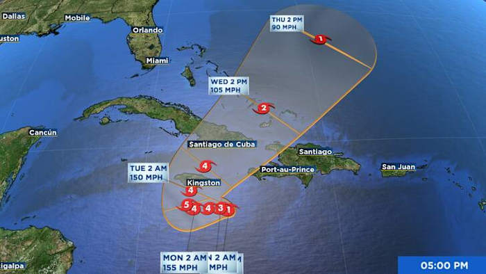
Sporting 115 mph winds, its center was 125 miles southeast of Kingston, Jamaica, and moving west at 3 mph, creating a dangerous situation for residents in Jamaica, Haiti, and parts of Cuba.
Rainfall totals of 1 to 3 feet are possible as the system moves slowly across the region. Jamaica is expected to face devastating conditions, with days of damaging winds and heavy rainfall beginning tonight.
Landslides and mudslides will be possible and could continue into early next week.
No description foundForecast track and intensity
Haiti could experience life-threatening flash flooding, along with strong, damaging winds and high rainfall totals. The Dominican Republic will also face the threat of heavy rain, flash flooding, and landslides.
Across eastern Cuba, the Bahamas, and the Turks and Caicos, the risk is increasing for dangerous storm surge, damaging winds, and heavy rainfall by midweek.
A strong cold front is forecast to arrive in Central Florida Wednesday into Thursday, which should help steer Melissa away from the Florida Peninsula.
No description foundPotential rainfall
According to forecast models, Jamaica, eastern Cuba, and parts of Haiti could see 1–2 feet of rainfall through Wednesday. This amount of rain increases the risk of flooding and landslides, particularly in low-lying and mountainous areas.
Rainfall potential GFSRainfall potential (Euro)Impacts beyond Jamaica
Haiti: Flooding and landslides are likely along the southern coast early next week, with significant rainfall expected.
Dominican Republic: Heavy rain, flooding, and gusty winds are possible through early next week as Melissa’s outer bands pass to the south.
Eastern Cuba: By midweek, the region could experience major hurricane-force winds, dangerous storm surge, and torrential rainfall as Melissa approaches or moves near the area.
Breaking News Alerts
More Stories Like This In Our Email Newsletter
Copyright 2025 by WKMG ClickOrlando – All rights reserved.