
ORLANDO, Fla. – It’s going to be an active weather day in Central Florida, with additional downpours returning to the region.
MONDAY
An approaching cold front to our north and Hurricane Melissa to our south will keep the area in an unsettled pattern for one more day.
This warm and soggy setup will fuel scattered to numerous showers and thunderstorms through the Monday afternoon and evening. Embedded in this activity, some cells could be strong with gusty winds, small hail and pockets of heavy rain.
[VIDEO BELOW: Heavy rain slams Titusville]
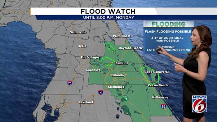
While we’re not expecting the extreme rainfall totals seen in parts of north Lake and north Brevard Sunday night, localized flooding is still possible, and a Flood Watch remains in effect until 8 p.m.
Highs will reach the mid-80s, with “feels like” temperatures in the mid-90s in some spots.
TUESDAY
By Tuesday, a shift to northerly winds behind the front will bring in drier, slightly cooler air, giving us a break from the rain.
Temperatures will range from the upper 70s in the north to the lower 80s elsewhere.
[VIDEO BELOW: No horses on Volusia beaches]
WEDNESDAY-WEEKEND
Midweek into the weekend, the strongest front of the season will sweep through Wednesday night. Once the front clears, it will be time to grab a jacket!
Highs will stay in the 70s Thursday through Saturday, with chilly mornings in the upper 40s to 50s inland.
The coldest point of the week will be Halloween morning with wake-up temperatures in the 40s and 50s.
Daily Forecast
The News 6 Weather team ensures you’re always on top of the day’s weather.
Copyright 2025 by WKMG ClickOrlando – All rights reserved.