
Sunshine Returns with Dangerous Rip Current Threat This Weekend In Central Florida
Sunshine Returns with Dangerous Rip Current Threat This Weekend In Central Florida
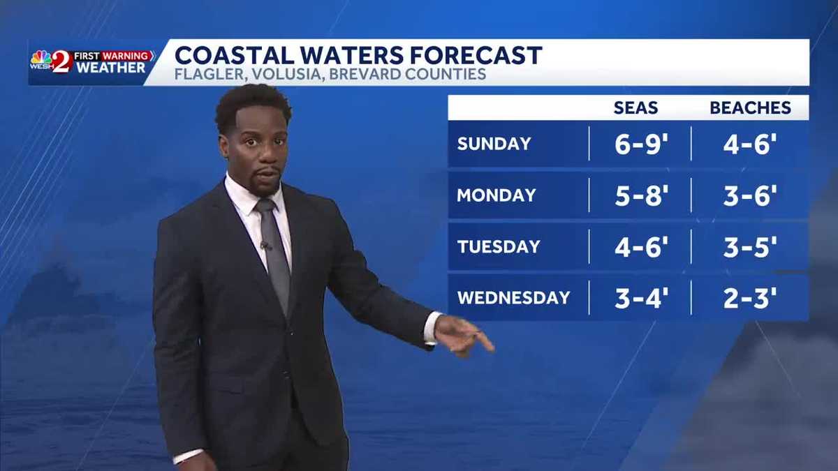
SHOW. IT GOES FROM 11 IN THE MORNING TILL TWO IN THE AFTERNOON. WE NEED THE ALL IMPORTANT BEACH FORECAST. IF YOU’RE HEADING OUT THERE, METEOROLOGIST MARQUISE MEDA JOINS US NOW. PICTURE PERFECT OUT THERE TODAY. MARQUISE. YEAH, THE SKYLINE LOOKS AMAZING, RIGHT? BARELY ANY CLOUDS IN SIGHT. THE OCEAN MATCHES THE SKY IN WHICH WE GET A LOT OF BLUE GOING ON HERE IN CENTRAL FLORIDA. UNFORTUNATELY, YOU DON’T SEE MANY PEOPLE IN THE WATER RIGHT NOW. THAT’S BECAUSE WE DO HAVE HIGH, HIGH AND DANGEROUS RIP. CURRENT THREAT THAT’S GOING TO STRETCH THROUGHOUT YOUR WEEKEND COMING UP. BUT HUNDREDS OF FOLKS ARE LINED UP ON THE COAST SOAKING IN THE SUNSHINE THIS WEEKEND HERE IN NEW SMYRNA BEACH. NOTICE THAT YOUR WINDS ARE SUSTAINED AT 14MPH. WE’VE SEEN SOME OCCASIONAL GUSTS IN THE VICINITY OF 20 TO 25 MILE PER HOUR CONDITIONS, AND THAT’S WHAT’S ALLOWING FOR THIS RIP CURRENT RISK TO REMAIN HIGH. AND YOUR WAVES COULD BE IN THE VICINITY OF 6 TO 9FT. TODAY, TEMPERATURES SHOW 75 DEGREES. WE’RE BACK IN THE 70S AND THE 80S THIS AFTERNOON, SOME OF US STILL HOLDING ON TO THE 80S AS YOU HEAD FURTHER WEST INTO WILDWOOD AND OCALA, 80 ON THE DOT OUT THAT DIRECTION. WINDS ARE A LITTLE BIT QUICKER IN ORANGE COUNTY. TAKE A LOOK AT THIS. WE’VE GOT GUSTS OF 22 MILE PER HOUR CONDITIONS IN HUNTER’S CREEK, ORLANDO INTERNATIONAL AIRPORT, 24. LAKE HART, 25, IS THAT SAME NORTH AND EASTERLY ORIENTATION IN WHICH WE DO HAVE THOSE HIGH CURRENT RISKS IN WAVES, WITH THOSE STRONGER GUSTS. ULTIMATELY, TEMPERATURES DID PEAK IN THE LOWER 80S IN ORLANDO TO TODAY HIT 80 ON THE DOT THERE. YOU MATCH THAT IN BITHLO. BUT WE’LL BE COOLING DOWN TONIGHT DROPPING INTO THE LOWER 60S UNDER THE CLEAR SKIES. SO WE’LL LET GO OF SOME OF THAT HEAT THAT WE ACCUMULATED THROUGHOUT THE DAY. BUT WE’RE STARTING OFF TOMORROW WITH SOME BEAUTIFUL SUNSHINE ONCE AGAIN HERE IN CENTRAL FLORIDA. COULD SEE SOME FOG OUT TOWARDS THE WEST. HERE’S A LOOK AT YOUR FOG TRACKER. DROPPING YOUR VISIBILITY DOWN TO TWO AND A HALF STATUTE MILES. SO WE’LL CALL IT PATCHY. IF YOU’RE ACROSS I-75 OUT TOWARDS THE WILDWOOD AREA TOMORROW MORNING. BUT TEMPERATURE WISE WILL BE COMFORTABLE, IF NOT A LITTLE BIT COOL WITH THOSE CLEAR SKIES TONIGHT DROPPING ANYWHERE BETWEEN 54 DEGREES INLAND AND 68 ALONG THE COAST. ULTIMATELY, HIGH PRESSURE IS GOING TO STICK AROUND FOR QUITE SOME TIME HERE IN CENTRAL FLORIDA. SO GONE ARE THE DAYS OF SOGGY WEATHER AND GRAY SKIES, AND WE’LL SEE A LOW TO MUCH MORE SUNSHINE THIS WEEKEND AS TEMPERATURES ARE SLOWLY GOING TO BEGIN TO WARM UP. STILL BREEZY THOUGH TOMORROW WITH THAT EAST COAST ORIENTATION. HIGH PRESSURE REALLY JUST HANGING OUT ACROSS THE CAROLINAS AND INTO THE ATLANTIC. SO THROUGH SUNDAY WE’LL CARRY A HIGH RIP CURRENT RISK, AND I WOULDN’T BE SURPRISED IF THE NATIONAL WEATHER SERVICE DOES PUSH THIS INTO THE WORKWEEK AS WELL. COMING UP. ULTIMATELY THOUGH, AS WE LOOK AT YOUR COASTAL WATERS, FORECAST WAVE HEIGHTS TODAY OR TOMORROW, ANYWHERE BETWEEN 6 AND 9FT SLOWLY OVER TIME, ONCE THE WINDS BEGIN TO SUBSIDE, WHILE YOUR WAVE HEIGHTS WILL COME DOWN, 3 TO 4 FOOT CONDITIONS WILL BE PRESENT AS WE HEAD INTO THE MIDDLE OF YOUR WORK WEEK, BUT IT’S GOING TO BE A HOT ONE HERE IN CENTRAL FLORIDA. AS WE PEEK AT YOUR UPPER AIR PATTERN, A RIDGE OF HIGH PRESSURE IS BUILDING THERE, SO THAT MEANS MORE SUNSHINE COMING YOUR WAY AND THE WARMING TREND WILL CONTINUE THROUGHOUT THE WORKWEEK, IN WHICH SOME OF US MAY SAY HELLO TO THE 90S. WE’VE DONE THAT THREE TIMES SO FAR HERE IN CENTRAL FLORIDA. SO WE’RE WELL AWAY FROM OUR AVERAGE FOR THE YEAR, BUT WE DEFINITELY HAVE THE TIME TO MAKE IT UP. IN FACT, WE COULD HIT THE 90S BY NEXT WEEKEND, WHICH MEANS DAY
Sunshine Returns with Dangerous Rip Current Threat This Weekend In Central Florida
Sunshine Returns with Dangerous Rip Current Threat This Weekend In Central Florida

Updated: 7:09 PM EDT Apr 11, 2026
Sunshine Returns with Dangerous Rip Current Threat This Weekend In Central FloridaHazardous beach and boating conditions continue through the weekend, with life threatening rip currents across all of our coastal communities. A few isolated showers are possible this afternoon, mainly in Southern Brevard County. Most areas stay dry with highs in the upper 70s to low 80s. Breezy onshore winds gusting 20 to 25 miles per hour develop this afternoon. Otherwise, dry and quiet conditions continue into Sunday and Monday with a gradual warming trend. Looking ahead, high pressure builds in bringing warm mostly dry weather all week with highs climbing into the mid 80s to near 90 by next weekend.
Sunshine Returns with Dangerous Rip Current Threat This Weekend In Central Florida
Hazardous beach and boating conditions continue through the weekend, with life threatening rip currents across all of our coastal communities. A few isolated showers are possible this afternoon, mainly in Southern Brevard County. Most areas stay dry with highs in the upper 70s to low 80s. Breezy onshore winds gusting 20 to 25 miles per hour develop this afternoon. Otherwise, dry and quiet conditions continue into Sunday and Monday with a gradual warming trend. Looking ahead, high pressure builds in bringing warm mostly dry weather all week with highs climbing into the mid 80s to near 90 by next weekend.