
Trending warmer for Thursday; Brush fire smoke in Collier County
Higher humidity will build back in by the weekend for Southwest Florida.
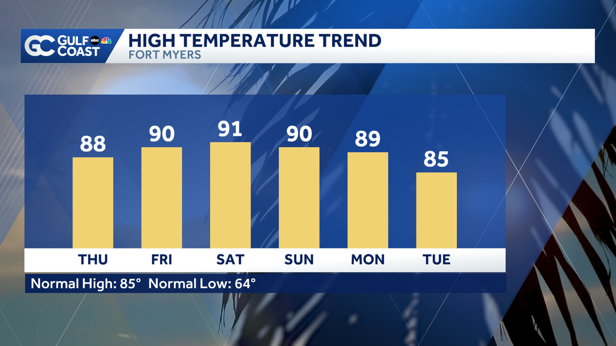
KICKED IN SOMEONE’S DOOR IN CAPE CORAL. WELL FEELS LIKE SUMMER. ALL OF A SUDDEN. >> IT DOES. WE ARE EXPECTING JUNE LIKE HEAT AS WE HEAD INTO THE WEEKEND. SO GREAT WEEKEND. IF YOU WANT TO GET OUTSIDE, MAYBE HEAD TO THE BEACH OR TO THE POOL. ALL RIGHT. I WANT TO START, THOUGH, WITH THE SMOKE FROM THAT MASSIVE BRUSH FIRE DOWN IN COLLIER COUNTY. WE SAW THE SEA BREEZE KICKING AND PUSHING THAT SMOKE BACK INLAND BACK TOWARD GOLDEN GATE ESTATES. NOW THE SEA BREEZE IS STARTING TO BREAK DOWN AND THE SMOKE IS TAKING A TRIP BACK OUT TO THE COAST OVER THE NEXT SEVERAL HOURS WAKING UP EARLY TOMORROW MORNING. WE’LL SEE THE WIND SHIFT JUST ENOUGH THAT WE’LL SEE DIP IN THE SMOKE AS THIS MAKES DOWN TO THE MARCO ISLAND AREA. WE’RE TALKING VERY, VERY EARLY BEFORE SUNRISE BY THE TIME THOSE THAT A LOT OF US ARE GETTING OUT AND ABOUT ON OUR MORNING COMMUTES. THAT’S WHEN THE WIND PICKS UP AGAIN, PUSHING THIS ALL BACK OUT TOWARDS THE COAST. KEEP THAT IN MIND. IF YOU TAKE 41 IN COLLIER COUNTY EARLY TOMORROW MORNING. NOW BECAUSE OF THIS, WE ARE SEEING THEIR AIR QUALITY BE NOT QUITE AS GOOD AS IT USUALLY IS RIGHT NOW. A LOT OF US SITTING IN THAT MODERATE CATEGORY. I’D RECOMMEND MAKING SURE YOUR WINDOWS ARE CLOSED IN IF YOU SUFFER FROM RESPIRATORY ISSUES, MAYBE CONSIDER LIMITING YOUR TIME OUTSIDE UNTIL THIS BRUSH FIRE GETS PUT OUT. BESIDES THAT THINGS ARE VERY CALM AND COOL ACROSS THE GULF COAST. WE’LL DROP DOWN INTO THE MID-SIXTIES. 64 IN FORT MYERS OUT THE DOOR TOMORROW MORNING. PARTLY CLOUDY. 66 IN CAPE CORAL WILL BE A STEADY WARM-UP. WE’RE INTO THE 80’S BY LUNCH. SOME SUNSHINE LIFTING US INTO THE MID TO UPPER 80’S FOR YOUR THURSDAY AFTERNOON. THAT PUTS US AT 88 IN FORT MYERS, 87 IN CAPE CORAL AND GORDA, RUNNING A FEW DEGREES THE AVERAGE FOR THIS TIME OF YEAR. WE’RE CERTAINLY GOING TO START TO FEEL THE HEAT AND IT GETS EVEN WARMER AS WE HEAD INTO THE NEXT SEVERAL DAYS. THAT’S DUE TO THIS AREA OF HIGH PRESSURE. I ALWAYS SAY HIGH PRESSURE MEANS HIGH TEMPERATURES AND THIS AREA OF HIGH PRESSURE IS NOT GOING ANYWHERE. THAT WILL SET THIS INTO THE 90’S FOR YOUR FRIDAY SATURDAY AND FOR YOUR SUNDAY SUNDAY, GETTING CLOSE TO THAT RECORD. THE RECORD 93, MY FORECAST, 90 DEGREES ACROSS THE BOARD, THOUGH IT IS GOING TO BE A TOASTY ONE. MAKE SURE THAT YOU’RE DRINKING PLENTY OF WATER IF YOU’RE OUTSIDE OF THE BEACH OR THE POOL, MAKE SURE THAT YOU ARE PACKING ON THAT SUNSCREEN. WE WILL BE TRACKING PLENTY OF SUN THROUGH THE WEEKEND PATTERN CHANGE, THOUGH, THE BEGINNING OF NEXT WEEK, A COLD FRONT RUSHING IN, GIVING US A BIT OF RELIEF FROM THE 90’S AND BRINGING RAIN CHANCES BACK TO THE GULF COAST. BUT A 30% CHANCE OF RAIN FOR YOUR MONDAY. NOW, I’M NOT EXPECTING ANYTHING WIDESPREAD BUT ENOUGH THAT WE COULD GET SOME MEASURABLE RAINFALL, ESPECIALLY FOR INLAND COMMUNITIES AND DOWN SOUTH AND INLAND COLLIER COUNTY, DESPERATELY NEED THE RAIN. WE’RE STILL TRACKING EXTREME DROUGHT ALL ACROSS THE GULF COAST. THAT’S WHAT YOU’RE SEEING IN RED ON YOUR SCREEN TODAY. WE ARE EXACTLY ONE MONTH OUT FROM THE START OF RAINY SEASON. ONCE WE GET THOSE AFTERNOON, THUNDERSTORMS COMING IN MORE CONSISTENTLY, WE WILL LIKELY SEE THAT DROUGHT START TO CLEAR OUT OF HERE. WE STILL A MONTH TO GO ON HERE’S THE NEXT 7 DAYS. NOT A TON OF RAIN IN THE NEXT SITES. THAT LITTLE PATTERN CHANGE EARLY NEXT WEEK. INSTEAD, WE’RE TRACKING PLENTY OF WARMTH. THE 90’S ARE HERE FOR YOUR FRIDAY SATURDAY AND SUNDAY. MORNINGS ARE INTO THE 60’S 70’S FOR THE NEXT LITTLE BIT COLD FRONT SWINGS THROUGH THAT WILL CREATE A FEW BREEZES FOR YOUR SUNDAY AND FOR YOUR MONDAY GIVING US SOME MUCH NEEDED RAIN. WE DRY OUT, THOUGH, AS WE HEAD INTO TH
Trending warmer for Thursday; Brush fire smoke in Collier County
Higher humidity will build back in by the weekend for Southwest Florida.

Updated: 11:30 PM EDT Apr 15, 2026
Calm, mild weather will persist through Wednesday night, but the heat is on Thursday afternoon. Temperatures will climb to the upper 80s under partly cloudy skies. Breezes will blow lightly, making for warm, but pleasant weather. Near-record heat and higher humidity return for the weekend. Highs will soar to the low-to-mid 90s with only stray showers each afternoon.The Gulf Coast Storm Team continues to monitor the Newman Drive Fire in the Picayune Strand State Forest, which has grown over 1,700 acres in size as of Wednesday. Tonight, a wind shift out of the east will drive most of the smoke inland once again near Golden Gate Estates. The wind is set to shift again Thursday morning, pushing the smoke back toward the coast. Gulf Coast News will keep you updated on the ongoing containment efforts on air and online.That’s your Gulf Coast Weather Most Accurate Forecast.Follow, like and subscribe to Gulf Coast News on social media to share your tips and be part of the conversation with Southwest Florida’s most experienced, trusted weather team.However you watch or scroll, we’re committed to delivering accurate, timely forecasts you can rely on, wherever you are.Follow on social media: Facebook | Instagram | YouTube | TikTok | Threads | Bluesky | Nextdoor | XLive Interactive RadarTrack conditions in real time with the Gulf Coast Live Radar.Watch Gulf Coast WeatherFind the latest weather forecast videos, streaming live or on demand, on TV and online.Stream on the GoDownload the free Gulf Coast News app to watch on your phone or tablet.Your Gulf Coast Storm TeamChief Meteorologist Allyson RaeMeteorologist Caroline CastoraMeteorologist Jim DickeyMeteorologist Jason DunningMeteorologist Lauren HopeMeteorologist Raphael TavernierMeteorologist Rob DunsMeteorologist Sara BlueDOWNLOAD the free Gulf Coast News app for your latest breaking news and weather alerts. And check out the Very Local Gulf Coast app to stream news, entertainment and original programming on your TV.
FORT MYERS, Fla. —
Calm, mild weather will persist through Wednesday night, but the heat is on Thursday afternoon.
Temperatures will climb to the upper 80s under partly cloudy skies. Breezes will blow lightly, making for warm, but pleasant weather.
Near-record heat and higher humidity return for the weekend. Highs will soar to the low-to-mid 90s with only stray showers each afternoon.
The Gulf Coast Storm Team continues to monitor the Newman Drive Fire in the Picayune Strand State Forest, which has grown over 1,700 acres in size as of Wednesday. Tonight, a wind shift out of the east will drive most of the smoke inland once again near Golden Gate Estates. The wind is set to shift again Thursday morning, pushing the smoke back toward the coast. Gulf Coast News will keep you updated on the ongoing containment efforts on air and online.
That’s your Gulf Coast Weather Most Accurate Forecast.
Follow, like and subscribe to Gulf Coast News on social media to share your tips and be part of the conversation with Southwest Florida’s most experienced, trusted weather team.
However you watch or scroll, we’re committed to delivering accurate, timely forecasts you can rely on, wherever you are.
Follow on social media: Facebook | Instagram | YouTube | TikTok | Threads | Bluesky | Nextdoor | X
Live Interactive Radar
Watch Gulf Coast Weather
Stream on the Go
Your Gulf Coast Storm Team
DOWNLOAD the free Gulf Coast News app for your latest breaking news and weather alerts. And check out the Very Local Gulf Coast app to stream news, entertainment and original programming on your TV.