
Isolated showers Thursday evening for Florida’s Gulf Coast
INFO IS ON OUR GULF COAST NEWS APP. >> RAFFLES AND A GOOD TIME TO GET OTHER GO FISHING. >> I THINK IT IT’S ALWAYS A GOOD TIME TO GO FISHING. YOU KNOW, A TYPICAL FISH. BUT AFTER THAT QUESTION THAT WAY. BUT WE ARE GOING TO BE TRACKING SOME INCREASING RAIN CHANCES FOR TODAY. SO THAT IS SOME GOOD NEWS HERE ACROSS THE GULF COAST. WE MOST CERTAINLY NEED THE RAIN ACROSS THE AREA. AND AS WE TAKE A LOOK AT OUR GOLF COURSE, WEATHER OUTLOOK, HE PROBABLY ALREADY NOTICED IT, BUT WE’RE GOING TO BE INCREASING THAT MOISTURE AND THAT WILL MAKE IT FEEL A LITTLE BIT MORE HUMID ACROSS THE AREA. AND THAT’S GOING TO BE THE TREND AS WE LOOK TOWARD THIS WEEKEND. AND EVEN NEXT WEEK. SO GET USED TO THAT. I WOULD SAY STICKY FEEL ACROSS THE AREA BECAUSE THAT IS MOST LIKELY HERE TO STAY FOR TODAY. WE’RE GOING TO BE SEEING THOSE EXPANDING RAIN CHANCES AND ALSO RAIN COVERAGE FOR TODAY. THAT MOISTURE DO I’M TALKING ABOUT IS HELPING TO MAYBE INCREASE OUR RAIN CHANCES AS WELL. AND AS WE LOOK TOWARD THE WEEKEND AND ESPECIALLY NEXT WEEKEND, CERTAINLY GOING TO NOTICE A RISING TREND IN OUR TEMPERATURES. AS WE TAKE A LOOK AT THE MOISTURE TRACKER HERE ACROSS THE AREA TO BIG THINGS STAND OUT. YOU CAN SEE THAT DRY AIR IN THE SOUTH, BUT ALSO A BIG PLUME OF MOISTURE HERE JUST TOWARD THE WEST. NOW, THIS IS GOING TO SOMEWHAT MOVE TOWARD THE SOUTH OF US. WE’RE NOT GOING TO GET INTO A LOT OF THIS MOISTURE, BUT A LITTLE BIT OF THAT MOISTURE MAY MOVE TOWARD EAST AND MAYBE GIVE US A FEW OPPORTUNITIES FOR SOME RAIN. IF YOU NOTICE THE CLOUD DECK IS MOVED JUST TOWARD THE WEST HERE OF OUR AREA. MOSTLY I WOULD SAY CLOUD-FREE OUR COASTAL SECTIONS ARE ALREADY STARTING TO KNOW SOME OF THOSE EASTERLY BREEZES JUST 2 COMPONENTS WORKING HERE. YOU’VE GOT THAT MOISTURE MOVING IN FROM THE WEST. AND ALSO SOME DAYTIME HEATING IS GOING TO CONTRIBUTE INCREASING OUR RAIN CHANCES NOW AS WE GET LATER ON INTO THE AFTERNOON AND ESPECIALLY AS WE HEAD TOWARD THE EVENING, THOSE RAIN CHANCES DO GO UP TO ABOUT 30% AND SOME LOCATIONS MAY EVEN SEE SOME MEASURE RAIN THIS EVENING. SO LET’S GO AND TIME IT OUT. AND IT’S GOING TAKE A LOOK AT WHAT WE’RE LOOKING AT. THE FUTURECAST SHOWS MOSTLY DRY RIGHT NOW AND MOSTLY DRY THROUGHOUT THE AFTERNOON. IT’S NOT UNTIL WE GET LATER. I WOULD SAY RIGHT AROUND THE EVENING TIME WE SEE SOME OF THAT MOISTURE STREAMING IN FROM THE GULF TOWARD THE EAST. THAT MAY HELP TO BRING OUR RAIN CHANCES UP IN SOME OF OUR COASTAL SECTIONS. BUT DEPENDING ON HOW MUCH CLOUD COVER WE GET, THERE MAY BE AN OPPORTUNITY FOR MAYBE EVEN A FEW OF THOSE. I WOULD SAY ISOLATED SHOWER SPARKING UP TO DUE TO DAYTIME HEATING. AND THAT’S WHAT WE SEE HERE. SOME OF THOSE SHOWERS BEGINNING TO POP UP IN SOME OF OUR SECTIONS HERE ACROSS THE GULF COAST. AND THERE MIGHT BE AN OPPORTUNITY AT THE SHOWERS MAY EVEN LINGER BEYOND OUR SUNSET FUTURE CAST HERE RIGHT AROUND 9.30, SHOWS THE POTENTIAL OF A SHOWER, MAYBE EVEN SOME HEAVY RAIN AND SOME OF OUR SECONDS HERE ACROSS LEE COUNTY. SO IT JUST REALLY DEPENDS ON HOW THE CLOUDS SET UP DETERMINES ON HOW MUCH WE CAN EXPECT FOR RAIN. NOW, LET’S TAKE A LOOK AT SOME OF THE ESTIMATES THAT WE CAN EXPECT MAYBE LATER ON THIS EVENING. THIS GOES ALL THE WAY OUT THROUGH LATER ON TONIGHT. SO PLACES HERE ACROSS THE GULF COAST, SOME MEASURABLE RAIN IS CERTAINLY POSSIBLE ACROSS THE AREA. PLACES LIKE CAPE CORAL SHOWING MAYBE EVEN THE POTENTIAL FOR MAYBE A HALF INCH OF RAIN. BUT PLACES LIKE MARCO ISLAND, MAYBE NOTHING. SO IT’S KIND OF ONE OF THOSE THAT HE’LL OF THE HAVE AND THE HAVE NOTS HERE ACROSS THE AREA. AND THAT’S ALL DUE TO INCREASING MOISTURE NOTICING. SOME OF THOSE ARE JUST BEGINNING TO POP UP IN SOME OF SECTIONS HERE ACROSS THE GULF COAST. AS WE GET LATER ON INTO OUR THURSDAY, NOTING THAT BIG PULL MOISTURE THAT IS GOING TO SNEAK TOWARD THE SOUTH. AND THAT’S GONNA MISS US. SO WE’RE NOT GOING TO VERY LARGE RAIN CHANCES. BUT WE ARE GOING TO SEE SOME RAIN CHANCES. NONETHELESS, CURRENTLY RIGHT NOW, MOSTLY DRY OVER BEAUTIFUL DAY IN FORT MYERS BEACH. TEMPERATURES BEGIN TO RISE. 80 DEGREES, DEW POINTS ALSO BEGINNING TO INCREASE AS WELL AS WE GET LATER ON INTO THE EVENING AFTERNOON. WE ALSO GOING TO BE JUMPING UP THOSE RAIN CHANCES MOSTLY DRY RIGHT NOW. BUT THAT IS EXPECTED TO CHANGE HIGH TEMPERATURE OF 84 DEGREES AS WE GET LATER ON INTO THE EVENING FOR TONIGHT, WE’LL SEE THOSE LINGERING SHOWERS STILL IN OUR FORECAST AS WE GET TO OUR FRIDAY SATURDAY, SUNDAY, RAIN CHANCES AT ABOUT 20% LOOKS DO OVER THE WEEKEND WILL SEE THE OPPORTUNITY FOR SOME SHOWERS AND MOSTLY IN THE AFTERNOON AND SOME OF OUR INLAND LOCATIONS. BUT NEXT WE CHECK THIS OUT. LOOK AT THAT. WE’RE GOING TO BE SEEING HIGH TEMPERATURES INTO THE LOWER 90’S. SO IT IS MOST CE
Isolated showers Thursday evening for Florida’s Gulf Coast

Updated: 12:56 PM EDT Apr 23, 2026
Expect isolated showers Thursday evening for areas across the Gulf Coast. An increase in moisture is helping to increase rain coverage over Southwest Florida, and some areas could see measurable rain. This moisture will also make it feel increasingly humid. Rising temperatures and increasing moisture will be the trend as we close out the week. Rain chances will remain fairly low, but a few afternoon showers are possible on Friday and during the weekend. Expect highs to top off near 90 degrees by Sunday. Next week will feature mostly dry weather and highs in the low 90s. However you watch or scroll, we’re committed to delivering your Gulf Coast Weather Most Accurate Forecast — one you can rely on every day, wherever you are.Live Interactive Radar: Track conditions in real time with the Gulf Coast Live Radar.Watch Gulf Coast Weather: Find the latest weather forecast videos, streaming live or on demand, on TV and online.Stream on the Go: Download the free Gulf Coast News app to watch on your phone or tablet.Your Gulf Coast Weather TeamChief Meteorologist Allyson RaeMeteorologist Caroline CastoraMeteorologist Jim DickeyMeteorologist Lauren HopeMeteorologist Raphael TavernierMeteorologist Rob DunsMeteorologist Sara BlueFollow on Social: Follow, like and subscribe to Gulf Coast News on social media to share your tips and be part of the conversation with Southwest Florida’s most experienced, trusted weather team: Facebook | Instagram | YouTube | TikTok | Threads | Bluesky | Nextdoor | XDOWNLOAD the free Gulf Coast News app for your latest breaking news and weather alerts. And check out the Very Local Gulf Coast app to stream news, entertainment and original programming on your TV.
FORT MYERS, Fla. —
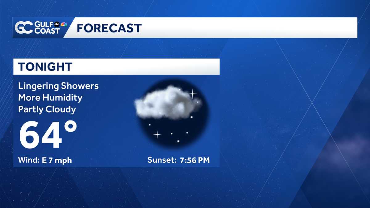
Expect isolated showers Thursday evening for areas across the Gulf Coast. An increase in moisture is helping to increase rain coverage over Southwest Florida, and some areas could see measurable rain. This moisture will also make it feel increasingly humid.

Rising temperatures and increasing moisture will be the trend as we close out the week. Rain chances will remain fairly low, but a few afternoon showers are possible on Friday and during the weekend. Expect highs to top off near 90 degrees by Sunday.

Next week will feature mostly dry weather and highs in the low 90s.
However you watch or scroll, we’re committed to delivering your Gulf Coast Weather Most Accurate Forecast — one you can rely on every day, wherever you are.
Live Interactive Radar: Track conditions in real time with the Gulf Coast Live Radar.
Watch Gulf Coast Weather: Find the latest weather forecast videos, streaming live or on demand, on TV and online.
Stream on the Go: Download the free Gulf Coast News app to watch on your phone or tablet.
Your Gulf Coast Weather Team
Follow on Social: Follow, like and subscribe to Gulf Coast News on social media to share your tips and be part of the conversation with Southwest Florida’s most experienced, trusted weather team: Facebook | Instagram | YouTube | TikTok | Threads | Bluesky | Nextdoor | X
DOWNLOAD the free Gulf Coast News app for your latest breaking news and weather alerts. And check out the Very Local Gulf Coast app to stream news, entertainment and original programming on your TV.