
If you’ve been keeping an eye on the rising number of wildfires in Florida or wondering if any are getting close to the Jacksonville area — there’s a helpful way to stay informed in real time.
The Florida Forest Service has an easy-to-use interactive map that lets you see exactly where fires are burning across the state in real time. It also breaks down how many acres have been affected and how much of each fire is contained.
➤ Weather alerts via text: Sign up to get updates about current storms and weather events by location
The number of active wildfires continues to climb, hitting 137 active fires burning more than 25,000 acres as of 6 a.m. April 23.
Take a look at the map below to stay informed and track fire activity and burn bans near you.
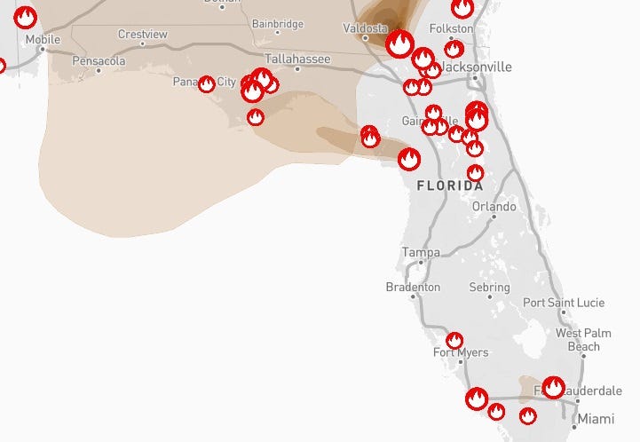
Map shows location of active wildfires, smoke impacts across Florida
As of 6 a.m. April 23, there were 137 active wildfires burning 25,248 acres across Florida.
According to the Florida Department of Agriculture and Consumer Services, between Jan. 1 and April 19 in Florida:
Number of wildfires: 1,797
Smelling smoke? See air quality across Florida
According to the EPA, despite the number of wildfires and associated smoke, air quality in the state range from good to moderate.
➤ See breakdown of air quality by Florida county
Burn bans in effect in 41 Florida counties
As of April 23, burn bans have been issued for 41 of Florida’s 67 counties, which includes all of the Jacksonville area. Check your county below:
What does the burn ban prohibit in Jacksonville and Duval County?
According to an email shared by the Jacksonville Fire Department, the ban prohibits all open burning within Duval County until further notice. Fire Chief Percy Golden II has invoked his authority under Jacksonville Municipal Code Section 420.202(e) to immediately ban all bonfires and open burning across the county. Current weather conditions pose an elevated risk to life and property.
Burn ban in St. Johns County? How long will it last?
St. Johns County officials enacted a countywide burn ban Monday evening due to extreme drought conditions. The order is set to remain in effect through April 27, though it may be extended if weather conditions and fire risk do not improve.
Interactive map: Enter your address to find closest wildfire risksStay informed. Get weather alerts via textWhat’s next?
We will continue to update our weather coverage as conditions warrant. Download your local site’s app to ensure you’re always connected to the news. And look for our special subscription offers here.
Doris Alvarez is a Breaking and Trending Reporter for The Florida Times-Union. You can get all of Jacksonville’s best content directly in your inbox each weekday by signing up for the free Daily Briefing and News Alerts newsletters at jacksonville.com/newsletters.
This article originally appeared on Florida Times-Union: How to track wildfires near Jacksonville