
Warmer temps, storms return ahead of hot week in Central Florida
ABOUT 2 A.M., WHEN THE ALARM WENT OFF. LIKE IT’S THE WEEKEND TIME. LISTEN, WE ARE STARTING OFF DARK AND EARLY. OF COURSE, IT’S GOING TO BE A BEAUTIFUL SUNRISE. WE’RE ADDING TWO THINGS INTO OUR FORECAST THIS WEEKEND. FIRST, HEAT. SECOND, SOME STORMS. TAKE A LOOK AT THE SEVEN DAY FORECAST BRINGING IT INTO THE MID 80S TODAY, WHICH IS OUR AVERAGE WHERE WE SHOULD BE THIS TIME OF YEAR. AND THEN WE KEEP CRANKING THOSE DIALS UP 8889 FOR SATURDAY, SUNDAY AND THE RAIN CHANCES ALSO RISING. SO LET’S LOOK TO THE WEEKEND JUST SO THAT, YOU KNOW, THIS IS GOING TO BE TOMORROW AFTERNOON. THE PLANS IN THE MORNING ARE FINE AND EVEN INTO THE AFTERNOON FOR OUR SATURDAY. WE ARE LOOKING GOOD. A FEW SPOTTY SHOWERS. THERE WILL BE SOME POCKETS OF HEAVIER STUFF, BUT THAT’S GOING TO BE MORE OF A DINNERTIME EVENING DEAL. THEN WE LOOK AHEAD TO SUNDAY. I THINK SUNDAY IS GOING TO BE THE MUCH MORE ACTIVE DAY, NOT IN TERMS OF SEVERITY, BUT IN TERMS OF OVERALL RAIN COVERAGE. THIS IS 9 A.M. I-4 ALREADY SEEING A FEW SHOWERS AND THEN JUST HIT OR MISS THROUGH MIDDAY INTO THE AFTERNOON. THE COVERAGE REALLY RAMPS UP AND EVERYTHING DOES WORK OFF TO THE EAST, BUT BASICALLY, AT ANY POINT IN TIME I’M GOING TO BE WATCHING SOME RAINFALL IN OUR AREA. SO JUST PLAN ACCORDINGLY. THE OTHER SIDE OF THIS, OF COURSE, IS THAT WE’RE STARTING TO LOOK MORE AND MORE LIKE SUMMER, AREN’T WE? TODAY, MID 80S UPPER 80S CLOSING IN ON THE 90 DEGREE MARK ALL THE WAY THROUGH THE WEEKEND AND EARLY NEXT WEEK, AND THEN BY LATE NEXT WEEK, LOOK AT SOME OF THESE TEMPERATURES. IF YOU LIVE ALONG THE COAST, YOU’RE LIVING ON EASY STREET, OBVIOUSLY LOW MID UPPER 80S, BUT THE INLAND SPOTS IS WHERE WE DIAL UP THAT HEAT. 91 DEGREES IN SANFORD, 93 IN ORLANDO, 92 IN CLERMONT, 9394 DEGREES OR SO FOR US OUT IN OUR WESTERN SPOTS. AND TO PUT THAT INTO PERSPECTIVE, THAT’S GOING TO BE IN THE BALLPARK OF RECORDS. SO WE’RE WRAPPING UP APRIL, GETTING INTO MAY WITH TEMPERATURES IN THE 90S, THIS WOULD BE THE HOTTEST THAT WE HAVE SEEN SINCE LAST SUMMER. SO GOOD TIMES. ALL RIGHT. THIS MORNING BEAUTIFUL HERE IN OCALA. WAKING UP MARION COUNTY 61 AT DAYTONA BEACH TOWER CAM NETWORK LOOKING FANTASTIC. YOU’RE SITTING AT 61 AS WELL. TEMPERATURES ELSEWHERE, 65 IN CLERMONT, 62 IN KISSIMMEE. IT’S A CLEAN SWEEP ON OUR LIVE RADAR, AND WE’RE GOING TO LOVE TO KEEP IT THAT WAY UNTIL THE AFTERNOON. THAT’S WHEN THAT 2,030% COVERAGE OF SHOWERS POPS UP. HIGHS TODAY RUNNING IN THE MID 80S. AND THOSE SHOWERS WILL HAVE THE COOLEST DOWN A LITTLE BIT. HIGHS. COVERAGE OF RAIN IS GOING TO BE KIND OF OUR INLAND AREAS. HERE’S FUTURECAST FOR TODAY SHOWING THAT LUNCHTIME GORGEOUS SUNSHINE ADDING IN THE CLOUDS. AND THEN THERE YOU GO. BY ABOUT 4 OR 5:00, WE’LL HAVE SOME SHOWERS TO CONTEND WITH, SO IT’LL BE FINE. NOTHING TOO STRONG TODAY. 30% COVERAGE USING THAT RAIN CHANCE THROUGH THE WEEKEND.
Warmer temps, storms return ahead of hot week in Central Florida

Updated: 6:35 AM EDT Apr 24, 2026
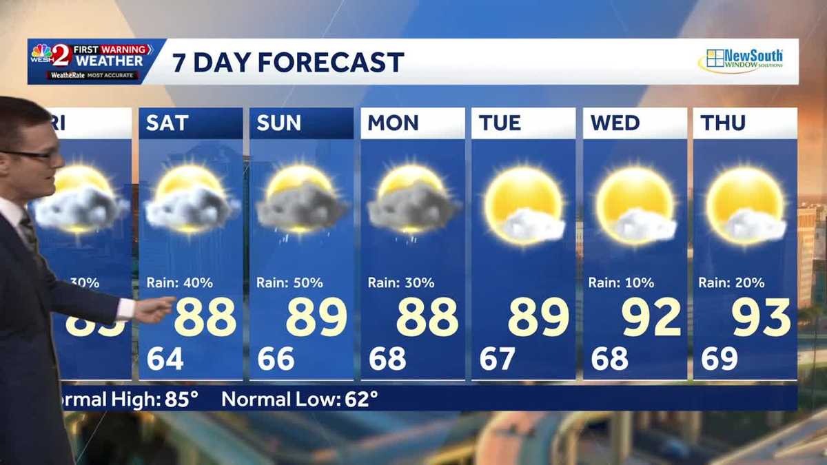
It’s a beautiful start to Friday across Central Florida, with mild conditions early and slightly warmer temperatures compared to recent mornings.A warming trend continues today, with afternoon highs climbing to around 85 degrees — right near seasonal averages. A few scattered showers are possible, though much of the day will remain dry.Heat and moisture build as we head into the weekend. Highs are expected to approach 90 degrees on both Saturday and Sunday, with rain chances increasing. Showers are likely to develop earlier in the day and transition into more widespread afternoon and evening thunderstorms through the weekend.Looking aheadEven hotter air moves in next week. Forecast highs are expected to reach the mid-90s, marking the hottest temperatures so far this year and the warmest conditions since last summer. First Warning Weather Stay with WESH 2 online and on-air for the most accurate Central Florida weather forecast.RadarSevere Weather AlertsDownload the WESH 2 News app to get the most up-to-date weather alerts. The First Warning Weather team includes First Warning Chief Meteorologist Tony Mainolfi, Eric Burris, Marquise Meda, Cam Tran and Victoria Wisniewski.
ORLANDO, Fla. —
It’s a beautiful start to Friday across Central Florida, with mild conditions early and slightly warmer temperatures compared to recent mornings.
A warming trend continues today, with afternoon highs climbing to around 85 degrees — right near seasonal averages. A few scattered showers are possible, though much of the day will remain dry.
Heat and moisture build as we head into the weekend. Highs are expected to approach 90 degrees on both Saturday and Sunday, with rain chances increasing.
Showers are likely to develop earlier in the day and transition into more widespread afternoon and evening thunderstorms through the weekend.
Looking ahead
Even hotter air moves in next week. Forecast highs are expected to reach the mid-90s, marking the hottest temperatures so far this year and the warmest conditions since last summer.
First Warning Weather
Stay with WESH 2 online and on-air for the most accurate Central Florida weather forecast.
Download the WESH 2 News app to get the most up-to-date weather alerts.
The First Warning Weather team includes First Warning Chief Meteorologist Tony Mainolfi, Eric Burris, Marquise Meda, Cam Tran and Victoria Wisniewski.