
Hurricane Melissa headed to eastern Cuba as a Category 3 storm Wednesday after bringing violent winds and heavy rainfall to Jamaica, where it made landfall as a Category 5 storm Tuesday.
Authorities in Cuba evacuated more than 735,000 people, Cuba’s President Miguel Díaz-Canel said on X. Forecasters said the Category 3 storm would unleash catastrophic damage in Santiago de Cuba and nearby areas.
Early Wednesday morning, Melissa had top sustained winds of 125 mph (205 kph) and was moving northeast at 9 mph (15 kph) according to the U.S. National Hurricane Center in Miami. The hurricane was centered about 80 miles (130 kilometers) west-southwest of Guantánamo, Cuba, and was forecast to move across the island through the morning.
Extensive damage was reported in parts of southern and southwestern Jamaica, including four damaged hospitals and more than half a million customers without power.
Melissa was then forecast to move toward the Bahamas and near Bermuda.
Here is what to know about the storm:
A record storm for Jamaica
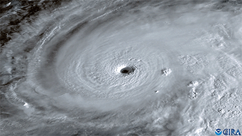
Melissa was a Category 5 hurricane, the highest level, when it made landfall Tuesday in Jamaica. It was the strongest to hit the island since recordkeeping began 174 years ago. Melissa caused power outages, fallen trees, landslides, and heavy flooding and tore off roofs in Jamaica.
The U.S. National Hurricane Center warned earlier that the situation was “extremely dangerous” and urged Jamaican residents to remain sheltered until the life-threatening conditions pass.
Hurricane Melissa’s 185 mph (295 kph) winds and 892 millibars of central pressure tied two records for the strongest Atlantic storm on landfall. The pressure — the key measurement meteorologists use — tied 1935’s Labor Day hurricane in Florida, while wind speed tied a 1935 hurricane and 2019’s Hurricane Dorian, said hurricane scientists Phil Klotzbach of Colorado State University and Brian McNoldy of the University of Miami.
U.N. agencies and dozens of nonprofits had food, medicine and other essential supplies prepositioned as they awaited a distribution rush after the storm.
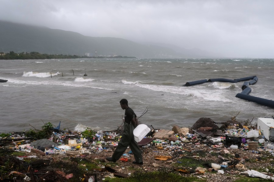 A man walks along the coastline during the passing of Hurricane Melissa in Kingston, Jamaica, Tuesday, Oct. 28, 2025. (AP Photo)
Other Caribbean nations at risk
The NHC warned that catastrophic flash flooding and landslides also are possible in Cuba and Hispaniola, the island which Haiti and the Dominican Republic share.
Cuban officials said they were evacuating more than 700,000 people from the region, including in Santiago, the island’s second-largest city.
The storm was expected to generate a storm surge of up to 12 feet (3.6 meters) in the region and drop up to 20 inches (51 centimeters) of rain in parts of eastern Cuba.
The NHC warned of 5 to 10 inches (13 to 26 centimeters) of rainfall with the potential for flash flooding in the southeastern Bahamas and the Turks and Caicos on Tuesday and Wednesday. Additional rainfall is expected in southern Hispaniola through Wednesday.
Rapid strengthening linked to climate change
Melissa reached tropical storm status last Tuesday and then became a hurricane on Saturday. Melissa then rapidly intensified into a Category 5 hurricane early Monday morning.
Climate scientists have linked warming ocean temperatures to hurricanes intensifying more quickly. Abnormally warm ocean waters of about 2 to 3 degrees Celsius (3.6 to 5.4 degrees Fahrenheit) above normal helped double Hurricane Melissa’s wind speed in less than 24 hours, scientists said.
Rapid intensification occurs when the maximum sustained winds of a tropical cyclone increase by at least 30 knots or 35 mph (56 kph). Warmer temperatures also give hurricanes fuel to unleash more rain.
Scientists said Melissa is the fourth storm in the Atlantic this year to undergo rapid intensification.
Storms that ramp up so quickly complicate forecasting and make it harder for government agencies and nonprofits to plan for emergencies.
A U.S. Air Force Reserve crew captured a rare view inside the eye of Category 5 Hurricane Melissa during a research flight.