
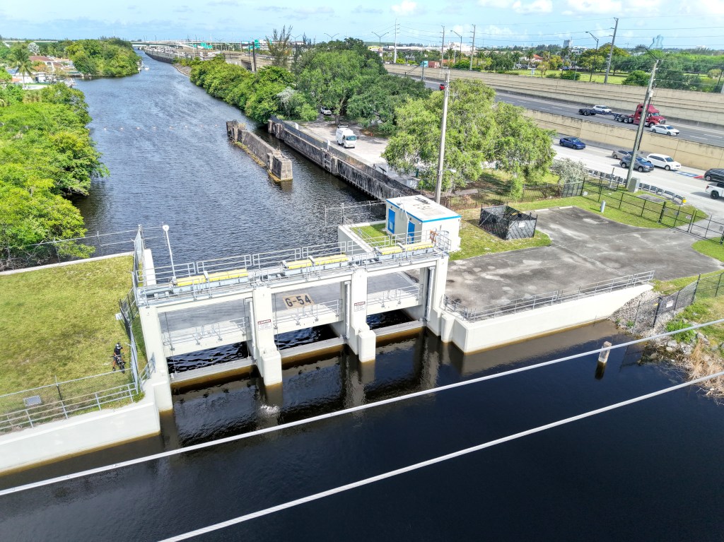
Drive around South Florida for a couple minutes and you’re bound to see a canal, maybe dozens of them — an 1,800-mile web of them in Broward County alone.
Their water levels are controlled by spillways that prevent flooding, keep salt water out of the region’s drinking water.
But many of the spillways are failing due to sea-level rise, according to the agency that controls them, and the anticipated 5 to 20 inches of sea-level rise in coming decades will be catastrophic for the region unless something drastic, and expensive, is done.
“We have 1,800 miles of canals that go through everyone’s neighborhoods, and unless we do something, in less than 10 years we’re going to see massive flooding,” said Broward County Mayor Mark Bogen at an April 14 Broward County Commission meeting.
A failure to act will result in massive flooding and higher flood insurance costs, even far from the coast, officials say. South Florida will have no way to send water to the ocean, and no way to stop salt water from intruding into its water supply.
The solution, according to the South Florida Water Management District, which operates the canals, is to add pumping stations to the spillways. During heavy rain events the pumps will shoot water from the western upstream parts of the canals to the downstream sections. Five of the most vulnerable spillways are in Broward County.
SFWMD’s 196-page plan for the pumps, dubbed the Central and Southern Florida Flood Resiliency Study Broward Basins (Section 203), still needs to be approved by the U.S. Army Corps of Engineers, and will take 12 years to execute.
It’s estimated to cost $1.8 billion and, if it works properly, will make the region flood resilient until the year 2060. This includes the cost of acquiring lands, construction costs, preconstruction engineering and design, construction management and contingencies, according to the plan.
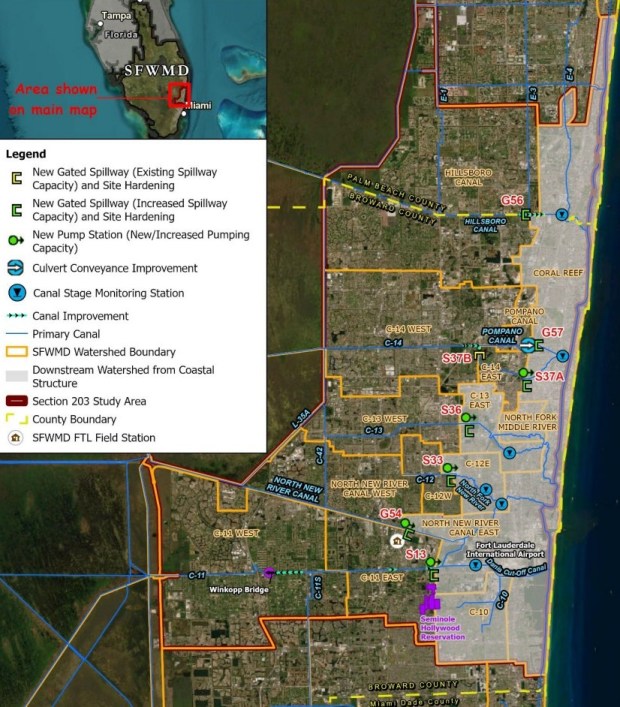 This maps shows proposed new pump stations and hardened spillways at five locations in Broward County. The proposed pump stations are designed to protect areas west of the spillways from flooding. (Courtesy SFWMD)
The cost would be shared between state, federal and local governments, with the federal government providing 65% of the cost and non-federal entities providing 35%.
Broward County commissioners put forward $5 million to partner with the South Florida Water Management District for the study.
Salt water intrusion
Flooding, and salt water breaching the top of the spillway, are not the only problem.
“Those gates, we should remember, are there for the purpose of protecting our well fields and keeping the salt water out,” said Jennifer Jurado, chief resilience officer for Broward County.
The spillway gates lift up from the bottom, Jurado said, so if the up-current pressure is too low, salt water can flow to the west. “Then you’d be bringing salty water in, in addition to compounding flooding,” she said.
Jurado noted that tongues of salt water are already encroaching into some of the freshwater areas of South Florida.
“As the gates are hardened, tightened, and elevated … those will be critical improvements for water supply protection as well,” she said.
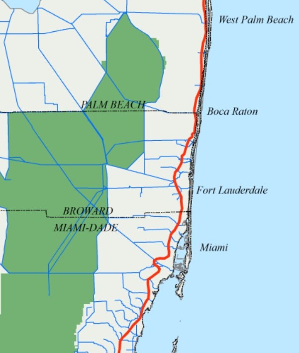 This map shows the estimated fresh water and salt water interface, shown as a red line, in the lower east coast for the years 1995 through 2000. (Courtesy SFWMD)
Carolina Maran is SFWMD’s chief of district resiliency.
She said at a recent South Florida Regional Planning Council meeting that aside from flood control through the year 2060, the plan’s other benefits include:
— $2.6 billion in avoided property damage.
— $264 million in total output during the construction period that is reflecting more jobs.
— A reduction of septic and sewer overflow.
— Protection against salt-water intrusion.
— An estimated $146 million in potential reduction in premium flood insurance costs.
How we got here
The matrix of canals in South Florida is part of a flood control system conceptualized in 1948, and flows water out of the Everglades and western suburbs and toward the sea.
The problem is that it was built for a different world — the world before sea-level rise and before Florida’s population spiked from 5 million in the 1960s to 23 million today.
Jurado said that in past decades, all of the development in the western two-thirds of metro Broward County was permitted under the assumption that the canal system would discharge rainfall to the coast.
In 2009, SFWMD issued a pivotal study, which found that 18 of their 28 water-control spillways in South Florida, which operate on gravity, were “highly vulnerable” to failure. Six of those were in Broward County.
That meant that because of sea-level rise, the water on the downstream east side of the spillways was almost as high — within 6 inches — as the water on the upstream west side of the spillways.
In order to work, the spillways need the downstream water levels to be lower.
During storm-surge events, or even some king tides, water levels are now equal, meaning no water can escape the western suburbs, and they flood during rain events.
“So much of sea-level rise had occurred since the time of design and construction of the system back in the 1940s that we were already losing discharge capacity,” said Jurado.
An example of this happened in November 2023 when 12 inches of rain fell on much of Broward and Miami-Dade counties. As areas west of the spillways began to flood, king tides pushed in from the ocean.
The king tides were just as high or higher than the flood waters to the west.
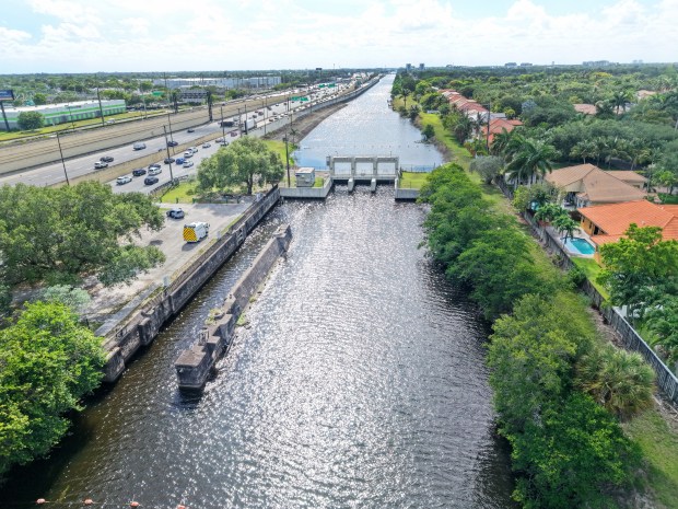 The G-54 gated spillway at the Sewell Lock between Plantation and Davie is one of five proposed pump sites in an ambitious plan to keep Broward County from flooding as seas rise. (Carline Jean/South Florida Sun Sentinel)
“As the storms were coming, we couldn’t do anything to lower the canals because the tides were too high,” said SFWMD Director Drew Bartlett at a resiliency panel discussion afterward. “You could open the gate two to three hours a day to try to get some water out to prepare for that storm, then when the storm hit, you had to wait for the canal water to get to a level that was higher than the coast to let it out.”
“We’ve had for years the colonels (at the U.S. Army Corps of Engineers) speaking to our water advisory board in Broward County on this topic and acknowledge it’s not a matter of when the system’s failing. They said publicly the system is already failing,” said Jurado.
The goal of the plan, said Maran, is to “restore the original discharge capacity that we lost by … intense urban development and sea-level rise.”
Sea-level rise and suburbia
Sea levels are rising both globally and locally by about a foot per century, according to SFWMD.
“Sea levels have been rising at a more rapid pace in the recent past in comparison to the last 2,000 years, said SFWMD’s 2009 report.
Their analysis indicated that sea levels in South Florida would rise between 5 and 20 inches by 2060, and continue to rise toward the year 2100.
The rise in sea levels is due to two main factors, said the report.
As seas warm they expand in volume, and thus rise.
Melting glaciers and ice caps also will add to sea levels. The science on how much of the Greenland and Antarctic ice sheets will melt varies.
Climate research indicates that though there may not be more hurricanes as a result of climate change, the storms that do form may be stronger and rain events in Florida may be more severe.
This is, in part, because hot air can hold more water, and hot seas fuel stronger hurricanes.
Bottom line: “The projected rises in ocean levels may limit the District’s ability to protect areas of South Florida from rain-driven flooding,” said the report.
Where the pumps could be
The final recommended plan that SFWMD sent to the Corps includes the installation of five new pump stations at existing spillway sites in Broward County.
These spillways also will be beefed up to increase water holding capacity. Three other spillways will be rebuilt for greater capacity and flow.
Proposed pump locations include:
— The S-13 Pump and Gated Spillway along the South New River Canal (C-11), just east of Florida’s Turnpike and west of the Fort Lauderdale-Hollywood International Airport.
— The G-54 Gated Spillway at the Sewell Locke between Plantation and Davie (6521 W State Rd 84, Davie, FL 33317). Water would flow into the South Fork of the New River.
– The S-33 Gated Spillway on the C-12 / Plantation Road Canal, just east of U.S. Highway 441, which discharges into the North Fork of the New River.
– The S-36 Gated Spillway in Fort Lauderdale along the C-13 Canal, which feeds the Middle River.
– The S-37A Gated Spillway on the C-14 (Cypress Creek) Canal, just east of Dixie Highway and the Florida East Coast Railway near Pompano Beach and Oakland Park.
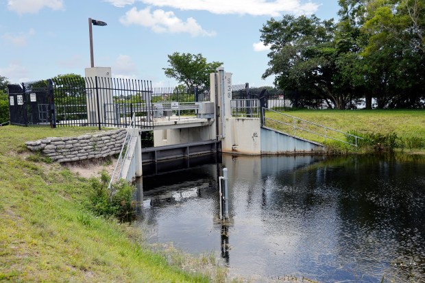 S-36 Spillway along the Middle River Canal in Oakland Park would get a pump station under the proposed plan from the South Florida Water Management District. (Amy Beth Bennett / South Florida Sun Sentinel)
What about downstream coastal flooding?
The area the plan will protect are those that lie west of the spillways — about two-thirds of Broward’s metro expanse.
But what of downstream areas closer to the coast?
“There’s been a lot of coordination with the coastal communities,” said Jurado. “One is the recognition that they’re going to be building seawalls anyway … the downstream condition, it’s going to be higher water levels and they will be elevating downstream infrastructure at the same time. They have to. We have ordinances that require those things, so that will be happening.”
“The improvements will also include more telemetry upstream and downstream and better ability to coordinate those discharges such that, for example, if downstream conditions are quite challenged by a combination of, say, surge and king tide, and there’s any flexibility in the system, we can delay those discharges and time everything … with greater precision.”
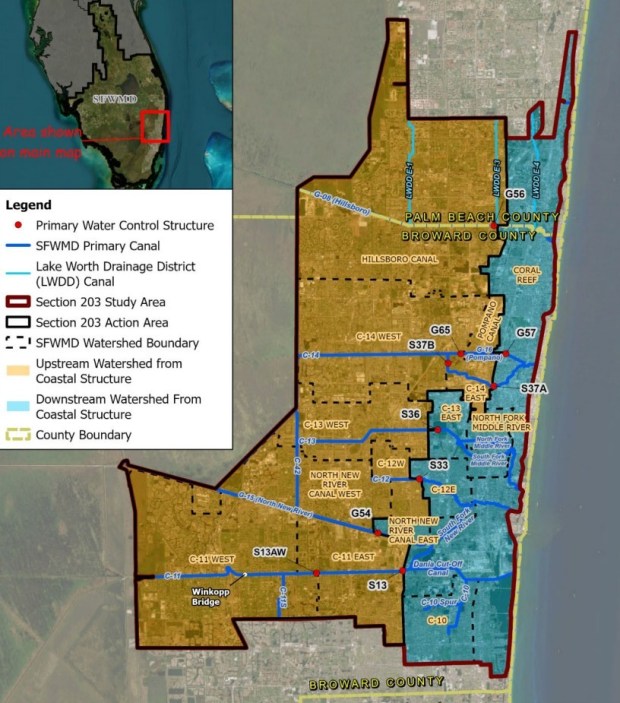 This map shows the upstream and downstream divide in parts of Broward County. Orange areas upstream are at risk of flooding as sea level rise renders gravity-dependent spillways inoperable. (Courtesy SFWMD)
An example would be timing pumps to discharge as the tide drops, or lowering canal levels before a king tide even shows up.
Beyond the pumps
In addition to pump stations, other spillways would be hardened and gates elevated to prevent overtopping.
The plan recommends improving culverts, and acknowledges that eventually some canals on the upstream west side may need to be deepened via dredging or by raising banks so they can store more water.
Jurado said that pollution and turbidity in the spillway discharge is a concern, too.
She said that underground storage and swales would need to be considered to keep dirty water from being flushed too quickly toward downstream areas and estuaries.
Timeline
Assuming the Army Corps approves the plan, it will then go to Congress for authorization and partial funding. The state and county will have to gin up money as well.
“We’re not even yet talking about the appropriations,” said Jurado. “We just need this to be authorized and then we can work on the next step.”
Jurado said that there would be 12 years for construction once Congress starts to appropriate funding, but the money will come in packages, not all at once.
“The idea is 2028 for construction underway and completed by 2040. That’s the goal,” she said. “We need to have these investments in the ground within 15 years.”
Jurado said that completion of the project will allow SFWMD to push water out of the bulk of Broward County and toward the ocean “even under conditions of extreme and high tides and rising sea levels. … The improvements are designed to be able to deliver the intended level of flood protection for the system but with the additional 2 feet of sea-level rise that we know is building.”
What happens to Broward County if this project doesn’t come to fruition?
“You could reliably anticipate quite extensive massive flooding for two-thirds of the county as your system is unable to release flood waters during storm events,” said Jurado.