
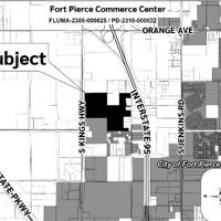
FORT PIERCE – The St. Lucie County Commission voted unanimously May 19 to approve Mixed Use District Land Use, Planned Non Residential District Zoning and the preliminary plan for a 76-acre project along Kings Highway to be known as the Fort Pierce Commerce Center.
Planning Manager Kori Benton provided a comprehensive overview of the request that day.
“This is a dual presentation for both agenda items,” he said. “The petition site is situated along the expanded Kings Highway Corridor. The proposed future land use designation is mixed use development. The proposed MXD District, specifically for the Commerce Center activity area, looks to restrict uses equivalent to the industrial land use designation provided that the development occur through the planned development process and an action by the Board of County Commissioners on that preliminary plan. It prescribes for open space, buffering and environmental protections along the eastern portion of the property to those established residential units.”
Benton proceeded to provide details of that plan.
“Approximately 27 percent of the overall land area is proposed for preservation,” he explained. “The buildings are proposed for up to a total of 826,000 square feet amongst three different buildings. Within the preservation area, we have various wetlands, their prescribed buffers and preservation of upland habitat, native trees and understory. The applicant has displayed the intent to meet land development code for those boundaries on the north, south and even along Kings Highway with a mixture of trees, shrubs and an eight-foot-tall opaque fence or wall as required by code.”
Benton spent the rest of his presentation focused on the potential of noise intrusion on the neighboring residences to the east and south for which the applicant had submitted a noise and sound assessment to analyze their building orientation. The developer chose, however, to place the loading docks and truck parking on that residential side of the property, a decision that county staff did not necessarily support.
“They’ve highlighted through that assessment the ability to comply with the county’s established noise ordinances across operations provided that geographic separation and buffer on the eastern portion of the site,” he said. “As part of staff’s review and from input through the Planning & Zoning Commission, staff is recommending an alternative be prescribed for that southeastern building. There’s approximately 300 feet from the rear property line of those large-lot estates to some of the activity areas for the Fort Pierce Commerce Center. Any reasonable measures and design features can be integrated to avoid adverse effects. Therefore, it’s our recommendation that the orientation of that building and the relocation of the employee parking be situated to the east, with loading activities on the west side of the building to allow the building [itself] to serve as additional buffering.”
The applicant’s contracted Land Planner Leslie Olson then came to the podium to provide a separate presentation. She began by first describing the reasoning behind her client’s choice of MXD Land Use before launching into the public input process that led to the applicant preserving more open space.
“When this was identified as a site by this client, they were thinking the addition of large-lot residential on the back end would be a good way to buffer this industrial site from the existing residential,” she said. “We brought this to a neighborhood meeting and they hated it. So we just preserved all of that back there, and the residents really appreciated that. We’re creating about an acre of wetlands and restoring about six acres of upland habitat.”
The developer had to be more creative for the residences along Samba Street to the south, however. “Here we have a heavy vegetated buffer, about 200 feet of the pond, and then another heavy vegetated buffer and then a wall after that,” Olson explained. “The people who live on Samba will be able to look through the new landscape buffer over the lake to another landscape buffer, a nicer backyard condition for them than just a wall.”
Olson also detailed the reasoning behind placing the loading docks on that side of the residences.
“When we took this to the Planning & Zoning Commission, staff recommended we flip the building to minimize impacts,” she explained. “One of the reasons we have not supported that is because of the truck routing. We have all the trucks on their own route through the site, and all the passenger cars on a different route. We can’t do that if we flip the building. We did a sound study because of those concerns and found there were no adverse impacts above and beyond what is established in the code. We would like to keep this arrangement because we think it is a safer situation.”
District 1 Commissioner James Clasby subsequently questioned both Olson and Benton on the building orientation. After the former insisted it was both a safety and aesthetics decision because she preferred the front of the building facing Kings Highway, Commissioner Clasby asked why the latter wanted to flip the building. Benton pointed out that passenger vehicle traffic was typically quieter.
“I think it was out of precaution,” Benton said. “The original design showed the loading on the west side. “The consumer-related traffic doesn’t have the potential for large refrigeration devices [and] the back-up beeping. So, it was out of an abundance of caution, independent of the sound assessment.”
After further discussion, the County Commission voted unanimously to approve the land use, zoning and preliminary site plan with the condition a wall be built on the residential side of the loading docks if the developer gets more than three noise complaints during any running six-month period.