
ORLANDO, Fla. – I hope your Halloween was as fantastic as the weather was around here in Central Florida!
If you’re not one to partake in the spooky festivities, regardless I hope that the final day of your October treated you amazing.
As we look ahead at the forecast for the first seven days of November, not a lot is changing which is an enormous sigh of relief for all of us after what happened this time last weekend with the heavy rains, flash flooding, and rogue tornado warnings.
Tonight we can see the early makings of a storm system trying to organize in the Gulf as our next cold front comes in (Copyright WKMG 2025)
We do have a weak storm system trying to come together in the Gulf – non-tropical, I promise. We’re just about done with that time of the year as well which is more good news to layer on to the whole forecast cake.
As it works its way towards us off the Texas coast headed eastward, we will see a slight increase in our humidity and moisture to work with in the local weather around our area. Clouds will come together a bit more than we’ve seen the last few days, and it will be noticeably muggier.
But nothing unbearable as if we were talking a pseudo spring or summer time type of set up!
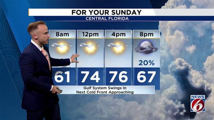
Into your Sunday evening, as the system in the Gulf approaches, we could see some spotty showers and light rains come up in Central Florida (Copyright WKMG 2025)
We’re looking at pretty low chances for rain across the board for all of us despite this next little nudge of moisture and a cold front slated to sweep over the state once again.
When we glance at how much water in the atmosphere is available to try and produce some rains in Central Florida, this addition is just not quite going to do the trick since we’ve been spending a lot of time with polar high pressure from up north.
Our in-house model suspects our next cold front will be draped directly overhead late Sunday into early Monday morning. As the front comes in from the Gulf coast, increased moisture will TRY to spark some occasional showers (Copyright WKMG 2025)
There is still a shot at some spotty rains as we go through late Sunday into Monday as a coastal low tries to take shape off our eastern shores before rocketing away from us. Then that’s about it.
Looking ahead it seems we’ll remain fairly dry, and temperatures will slowly start to rebound back into the 80s as high pressure ridging takes control of the set up over the southeast US.
We’ll be in for a bit of an up and down episode the next few days until temperatures finally climb back up to average and then above average by next weekend (Copyright WKMG 2025)
It doesn’t look like we’ll have any major shots for rain over the next several days, maybe the first two weeks of November. Climate Prediction Center agrees with this outlook, highlighting us for below average rains and above average temperatures at least until mid-November.
The cold fronts will keep coming, we’ll just be on a bit of a break for the foreseeable future after we can rid the jet stream of Melissa’s influence.
Speaking of Melissa – it’s been a remnant low since yesterday afternoon. What was once a record-setting, historic category five almost vanished without a trace after exiting the Caribbean Sea.
No tropical activity expected for the next seven days; a sight for sore eyes. (Copyright WKMG 2025)
The tropics are quiet, with no activity forecast for the next seven days according to National Hurricane Center. I am not actively tracking any prominent signals to monitor in the Caribbean, the Gulf, nor the Atlantic. Perhaps this is truly the end of the 2025 hurricane season once and for all.
If anything changes, I’ll be sure to let you know ASAP!
Daily Forecast
The News 6 Weather team ensures you’re always on top of the day’s weather.
Copyright 2025 by WKMG ClickOrlando – All rights reserved.