
WeatherTiger’s Hurricane Watch is a reader-supported publication. Paid subscribers get Florida-focused daily tropical briefings, plus coverage of every U.S. hurricane threat, our exclusive real-time seasonal forecast model, and the ability to comment and ask questions. And check out our WeatherTiger Pro service for market- and trading-oriented data solutions.
Miami and hurricanes. Like bacon and eggs or Carlos Santana and Rob Thomas, these things just go together. When I say Miami, you say hurricanes.
Climatologically, that makes sense. History shows that South Florida, along with coastal North Carolina and eastern Louisiana, has the shortest return period between hurricane landfalls in the continental U.S., with one expected roughly every 6 years and a Category 3 or above every 15 years or so.
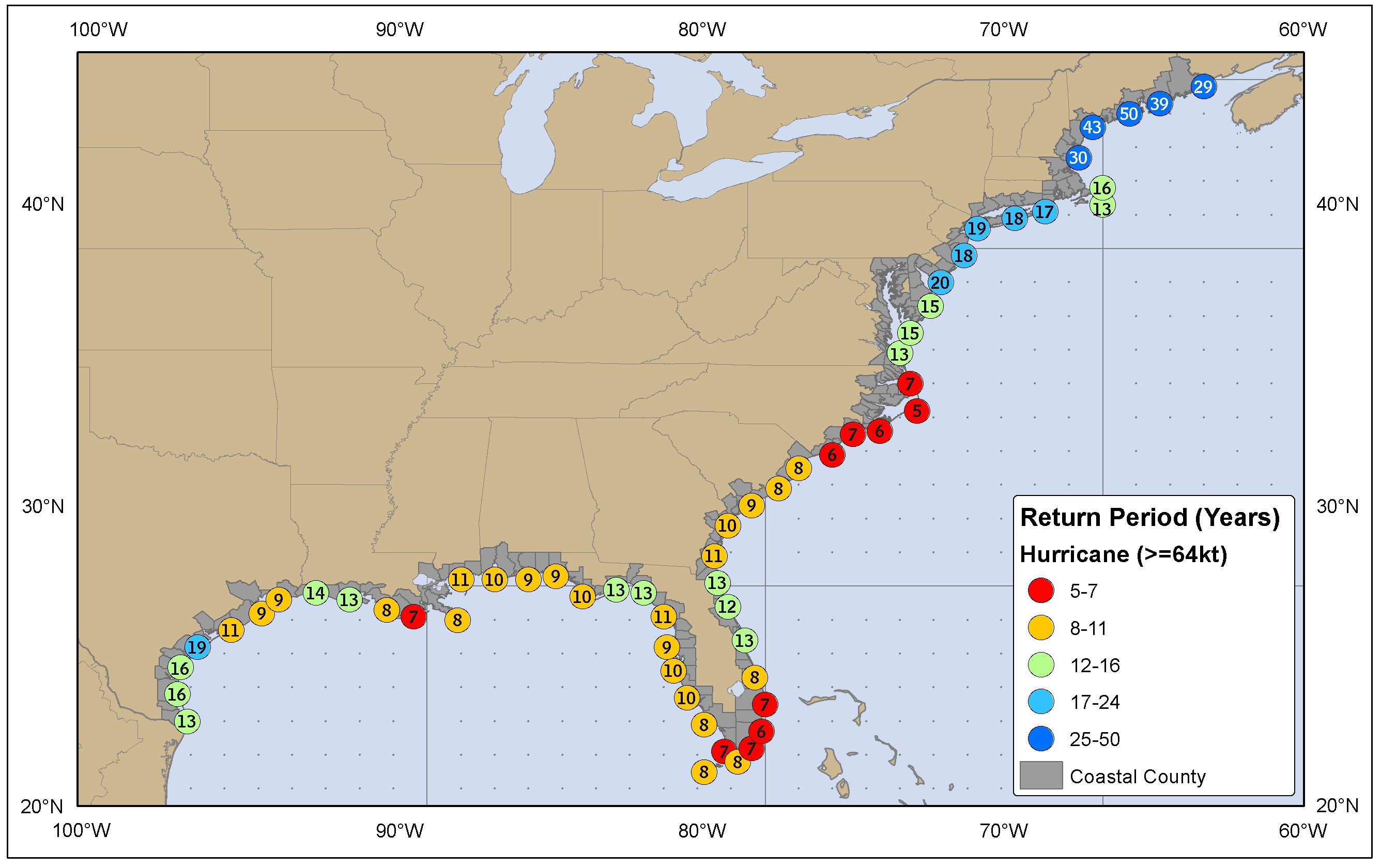 Estimated return period for a hurricane passing within 65 miles of a given location, by U.S. coastal county. Image: NHC.
Still, this is a fact-optional society. Culturally, the real reason for the inextricable Miami-hurricane link is The U. But back, back, way back before Turnover Chains, swagger, Wides Right, or Survivor: Nicaragua 18th-place finisher Jimmy Johnson, there was the storm that gave The U its name: the Great Miami Hurricane of 1926, which struck 100 years ago this week.
The Miami Hurricane.
If every hurricane in the last 175 years was re-staged with today’s development and risk mitigations in place, the Great Miami Hurricane of 1926 would be the worst, most expensive storm of them all. A fresh estimate puts the insured losses of such a scenario at a staggering $200 billion. The rule of thumb is that net damage is roughly twice insured losses, lofting the total price tag of a 1926 re-run to the ballpark of half a trillion dollars.
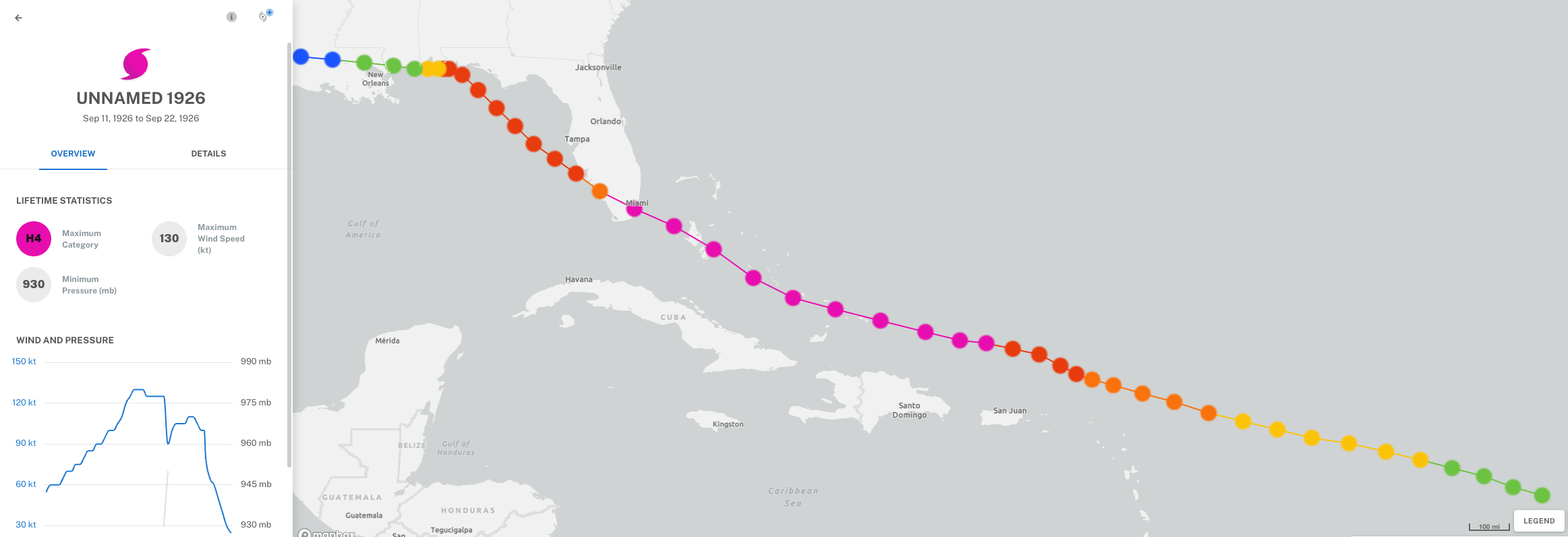 Track and intensity of the 1926 Great Miami Hurricane, September 11-22, 1926. Image: NOAA.
The 1926 hurricane’s toll in human terms is uncertain but massive, officially 373 deaths and another 811 missing. We can only hope those numbers would be lower if it happened again, but there are no guarantees.
That kind of economic and human carnage is only possible when two things are true. First, the hurricane must be a monster, and the Great Miami Hurricane certainly rates with the very fiercest storms to ever strike the continental U.S. Its estimated maximum sustained winds at landfall of 145 mph tie it for the thirteenth-strongest U.S. strike since 1851. While most instruments were destroyed during the storm, an anemometer on the roof of a Miami Beach hospital recorded a sustained wind of 138 mph in the northeastern eyewall. Gusts no doubt exceeded 150 mph. (Check out Dr. Brian McNoldy’s very cool reconstruction of the windfield of the 1926 Hurricane here.)
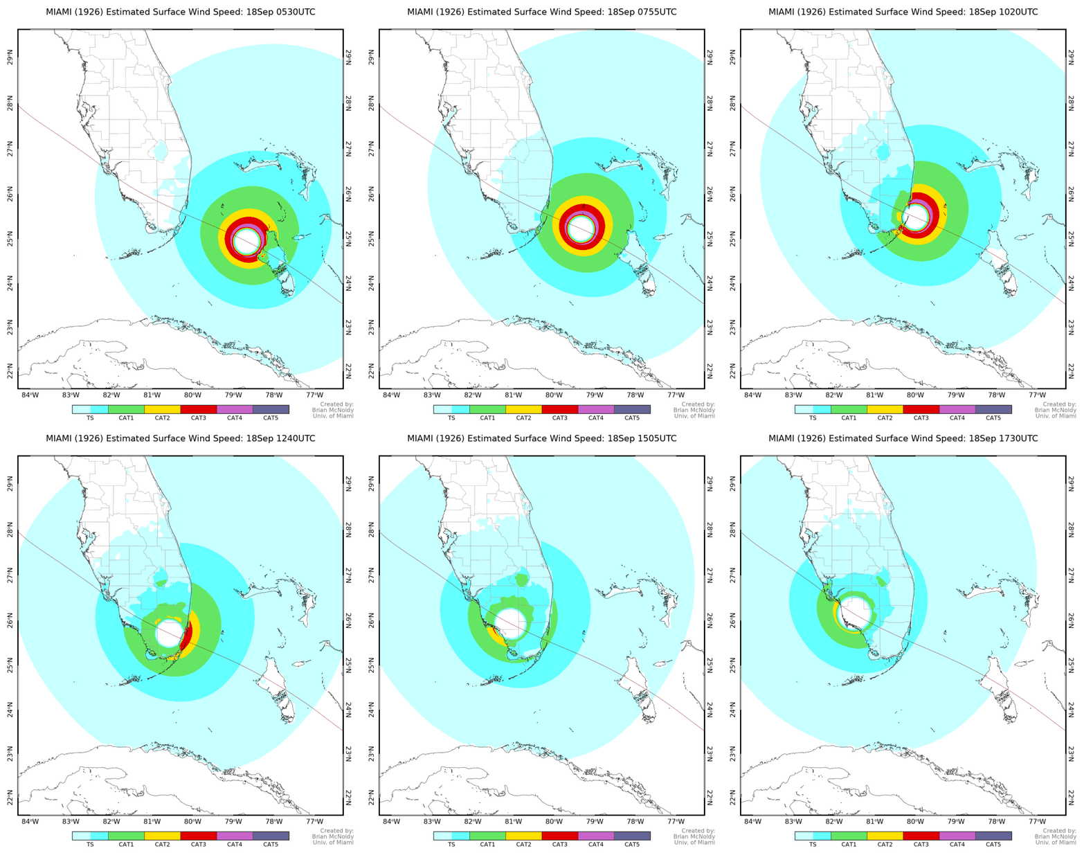 Estimated sustained surface winds experienced during the 1926 Great Miami Hurricane between 1:30 a.m. and 1:30 p.m on September 18, accounting for realistic land friction values. Image: Dr. Brian McNoldy, University of Miami.
The strongest winds extended an above-average 20 to 25 miles out from the hurricane’s center, spreading the worst devastation over a 50-mile wide swath of South Florida. These prolonged, extreme winds left a 17-story skyscraper akimbo over 1st Avenue in downtown Miami, collapsed buildings in Fort Lauderdale, pushed Lake Okeechobee over its dike into Moore Haven, and lopped 30’ off a 3,500-year-old cypress tree in Seminole County. The hurricane made a second landfall in Pensacola at Category 3 intensity, also causing severe damage in the Panhandle.
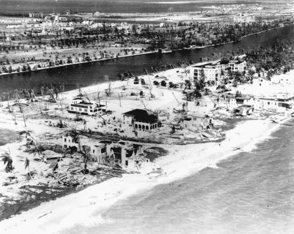
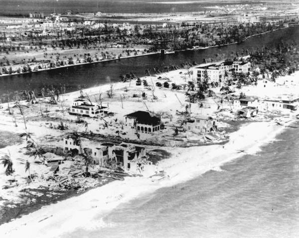 Miami Beach following the 1926 Great Miami Hurricane. Image: State Library and Archives of Florida/FloridaMemory.com.
For all its fury, the impacts of the Great Miami Hurricane were amplified to historic echelons by a maximally unfortunate track and timing. The hurricane approached Miami from the east-southeast at a 20-mph clip, dodging the handful of island weather stations that would have provided some warning to the hundreds of thousands of new residents of South Florida. While the Miami Weather Bureau office issued the equivalent of a Tropical Storm Warning at noon on September 17, weather conditions in Miami remained innocuous through the evening hours. Few preparations were taken.
As the barometer plunged and the first bands arrived, the Storm Warning was upgraded to a Hurricane Warning at 11 p.m. By 5 a.m., the western eyewall reached downtown Miami, with northeast winds gusting to 115 mph.
The center of circulation struck land in southern Miami-Dade County, between where Cutler Bay and Pinecrest are now, around sunrise on September 18. The calm eye of at the center of the tempest was more than 35 miles wide, extending from south of Homestead to northern Miami Beach.
This trajectory was (and is) a worst-case scenario. The rapid forward speed of the Great Miami Hurricane meant that the strongest winds of the storm were in the northeastern eyewall; the landfall point precisely targeted that northeastern eyewall—and the worst of the storm surge—to the developing urban core of Miami, Miami Beach, Coconut Grove, and Coral Gables.
Unfamiliar with hurricanes, terrified residents fled damaged buildings in the eye, believing the storm to be over. Many tried to drive across the causeway from Miami Beach to Miami during the lull, even as Weather Bureau officials pleaded with them to return to shelter and brace for even worse.
When the northeastern eyewall arrived at 6:45 a.m., the rush of southeast winds brought a 12’ storm tide that inundated the entirety of Miami Beach and pushed Biscayne Bay three blocks inland into downtown Miami over the next two hours. Cars on the causeway were swept away, followed by portions of the causeway itself. Peak surge was estimated by the head of the Miami Weather Bureau at 14’ to 15’ in Coconut Grove, an area record that stood until the much smaller (though even more intense) Andrew in 1992.
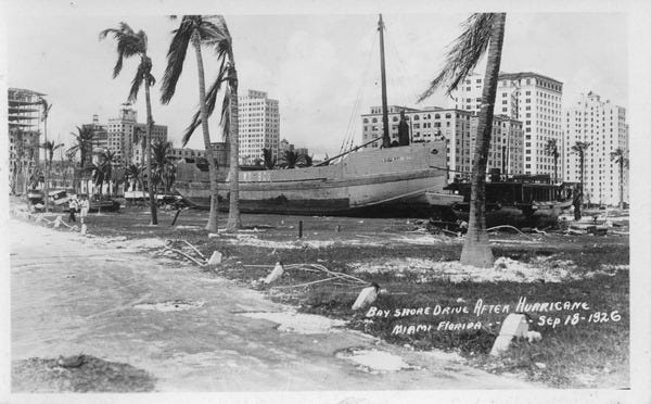 Ship on Bayshore Drive, September 18, 1926. Image: State Library and Archives of Florida/FloridaMemory.com.
It is hard to overstate the significance of the Great Miami Hurricane. Short-term, with over 1,000 dead or missing and civic infrastructure reduced to rubble by wind and surge, many left South Florida and the Flagler land boom went bust. Miami property values dropped by up to 99%, ushering the Great Depression into Florida three years early. (Like the ibis, the speculators would return.) Longer term, the 1926 hurricane contributed to the development of better though still inadequate building codes, increased efforts to educate the public about hurricanes, and a slow reorganization within the Weather Bureau that would eventually lead to the founding of the National Hurricane Center in 1955. In Miami, of course.
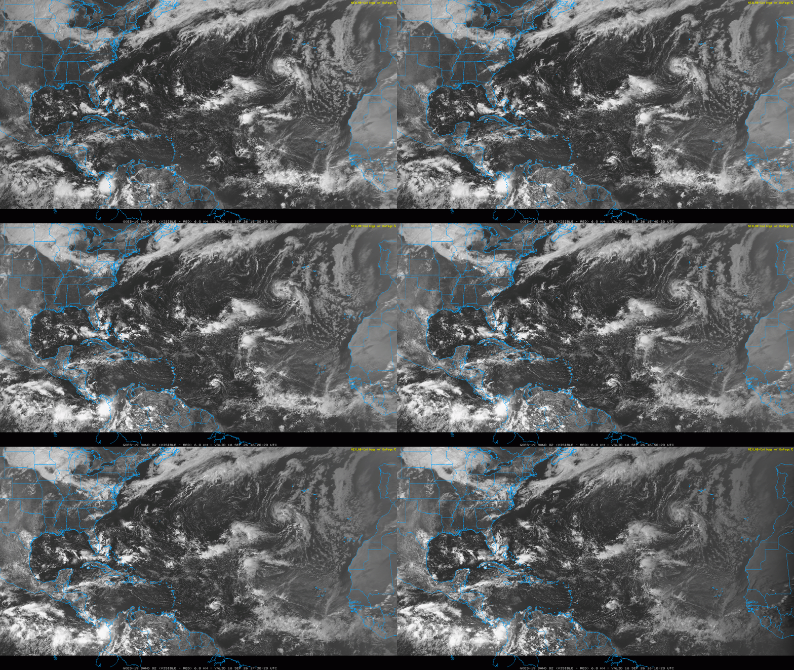 Friday PM visible satellite imagery via College of DuPage.
As we survey the curiously calm waters of the Atlantic exactly 100 years later, hopefully the mitigation and preparedness lessons of this tragedy have been osmosed into our cultural DNA rather than forgotten apart from team nicknames. In 2026, folks should know better than to rush across a bridge during the eye of a hurricane, but some still might if they saw a compelling #Cat4Challenge TikTok. Who knows.
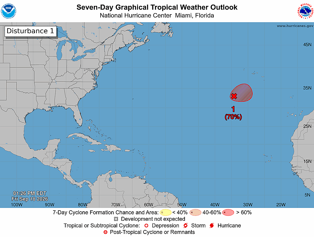 A tropical disturbance in the eastern Atlantic has a 70% chance of development in the next two days, but is no threat to land. Image: NHC.
Given the extremely unfavorable environment for tropical development this season, I don’t think we’re going to have to find that out in the near future, but tropical threats can’t be ruled out entirely. A likely candidate for the sixth named storm of the year is adrift in the open Atlantic today, thousands of miles east of Florida near the Azores. Even if this disturbance does become Fay, it will be no threat to land. Elsewhere, I don’t expect tropical development in the next week, though I would note that some longer-range ensemble models suggest overall pattern changes will result in a less hostile environment for development in the Gulf or western Atlantic towards the end of September or beginning of October. As to whether any disturbances will materialize in that potentially lower shear environment, it is too early to say.
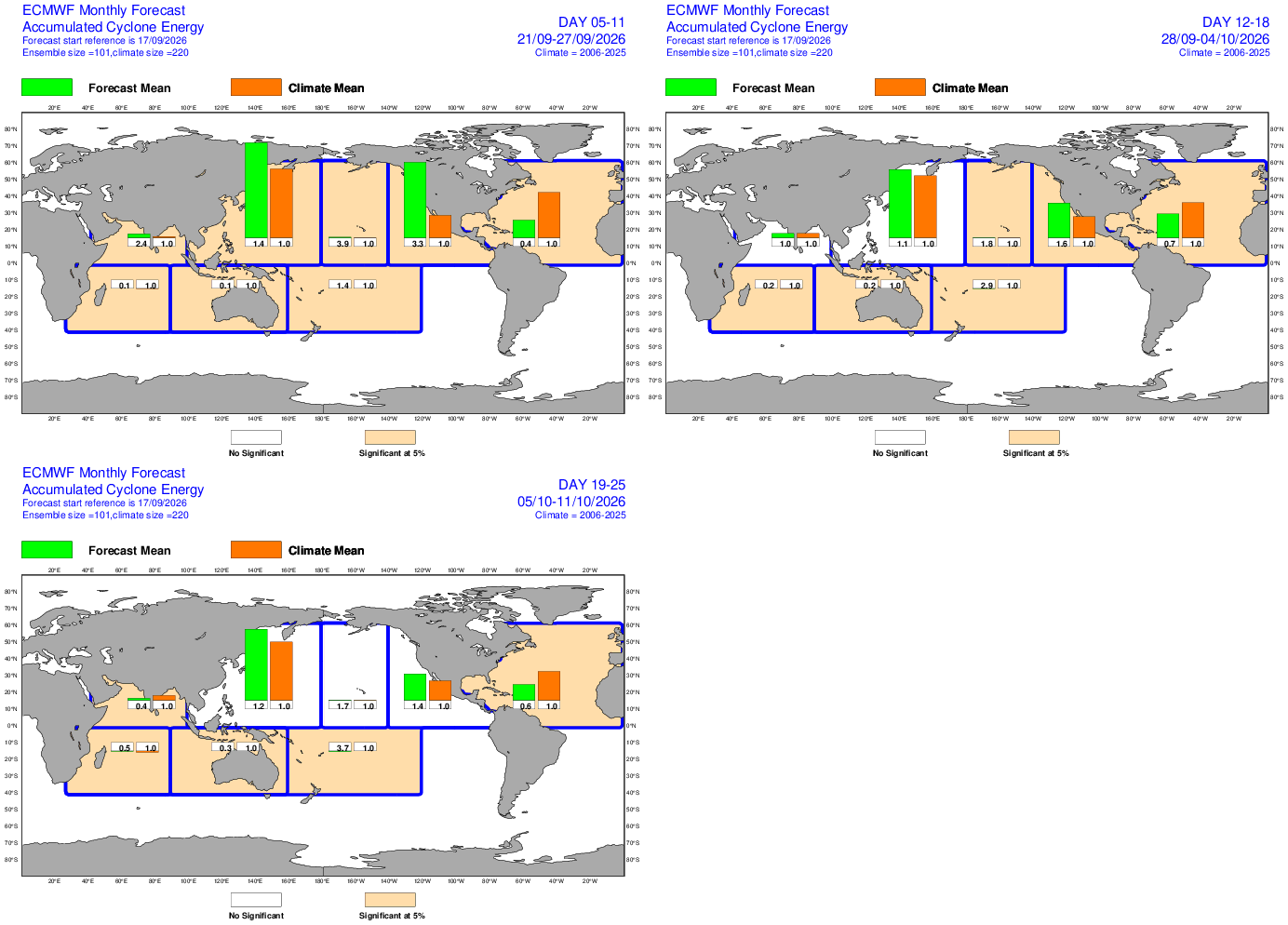 European weekly model forecast showing around 40% of normal tropical activity in the Atlantic through the next 10 days, followed by 70% for days 11-17 and 60% on days 18-25. While still below average, this shows general environmental conditions may be a little closer to normal around the beginning of October. Image: ECMWF.
It has been 21 years since a hurricane has made landfall in South Florida from the east, and after this year, it will almost certainly be 22. Nevertheless, learn from history, and keep watching the skies.