
An isolated shower is possible Sunday evening as a cold front approaches Southwest Florida. As this frontal boundary closes in on the Gulf Coast late Sunday night, increased winds and a few showers are expected overnight. The passage of this cold front will take place early on Monday morning. Cloudy skies, breezy conditions, and a few showers are possible as this front continues to move southward over the area. High temperatures in the lower 70s will be observed earlier in the day, and by the afternoon, temperatures will drastically begin to drop throughout the remainder of Monday. By the evening, skies will begin to clear, setting the stage for a very chilly Monday night. Temperatures will quickly drop into the 50s shortly after sunset and will continue to tumble throughout the night. Record-breaking cold is forecast throughout many locations across the Gulf Coast Tuesday morning. The record low in Fort Myers on Tuesday is 41 degrees, and your Gulf Coast Storm Team is forecasting to tie that record with a low temperature of 41 Tuesday morning. Places like Punta Gorda and Naples are forecast to break records Tuesday morning. Widespread 40s will reach even the most southern parts of Collier County, and upper 30s are expected for inland areas and cities in Charlotte and DeSoto counties. Gradual warming will slowly begin on Wednesday, but below-normal temperatures are expected until the weekend. The Atlantic hurricane season runs from June 1 through Nov. 30. Follow Gulf Coast News online and on air for Southwest Florida’s Most Accurate weather forecast.Be prepared with the Gulf Coast News 2025 Hurricane GuideLive Interactive RadarCheck out the interactive Gulf Coast Live RadarWatch your Gulf Coast Weather forecasts on TV or onlineHere’s where to find our latest weather forecast videoYou can also watch newscasts live or on demand hereOr download the Gulf Coast News app to stream on your phone or tabletFollow the Gulf Coast Storm Team on social mediaChief Meteorologist Allyson Rae on Facebook and XMeteorologist Sara Blue on Facebook and XMeteorologist Caroline Castora on Facebook and XMeteorologist Jim Dickey on Facebook and XMeteorologist Jason Dunning on Facebook and XMeteorologist Rob Duns on Facebook and XMeteorologist Lauren Hope on Facebook and XMeteorologist Raphael Tavernier on Facebook and XDOWNLOAD the free Gulf Coast News app for your latest breaking news and weather alerts. And check out the Very Local Gulf Coast app to stream news, entertainment and original programming on your TV.
FORT MYERS, Fla. —
An isolated shower is possible Sunday evening as a cold front approaches Southwest Florida. As this frontal boundary closes in on the Gulf Coast late Sunday night, increased winds and a few showers are expected overnight.
The passage of this cold front will take place early on Monday morning. Cloudy skies, breezy conditions, and a few showers are possible as this front continues to move southward over the area. High temperatures in the lower 70s will be observed earlier in the day, and by the afternoon, temperatures will drastically begin to drop throughout the remainder of Monday.
By the evening, skies will begin to clear, setting the stage for a very chilly Monday night. Temperatures will quickly drop into the 50s shortly after sunset and will continue to tumble throughout the night.

Gulf Coast News
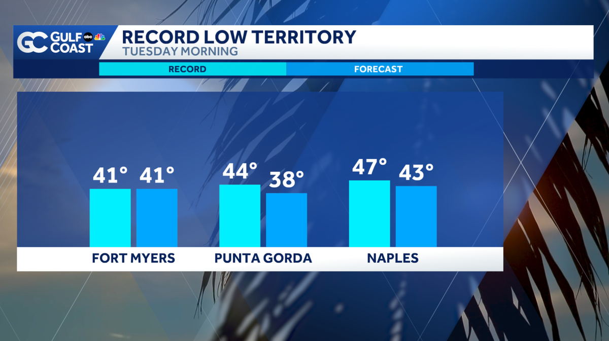
The city of Fort Myers is expected to tie the record low for Tuesday morning. Punta Gorda and Naples are expected to break record low temperatures on Tuesday.
Record-breaking cold is forecast throughout many locations across the Gulf Coast Tuesday morning. The record low in Fort Myers on Tuesday is 41 degrees, and your Gulf Coast Storm Team is forecasting to tie that record with a low temperature of 41 Tuesday morning. Places like Punta Gorda and Naples are forecast to break records Tuesday morning.


Widespread 40s will reach even the most southern parts of Collier County, and upper 30s are expected for inland areas and cities in Charlotte and DeSoto counties.

Gradual warming will slowly begin on Wednesday, but below-normal temperatures are expected until the weekend.
The Atlantic hurricane season runs from June 1 through Nov. 30. Follow Gulf Coast News online and on air for Southwest Florida’s Most Accurate weather forecast.
Live Interactive Radar
Watch your Gulf Coast Weather forecasts on TV or online
Follow the Gulf Coast Storm Team on social media
DOWNLOAD the free Gulf Coast News app for your latest breaking news and weather alerts. And check out the Very Local Gulf Coast app to stream news, entertainment and original programming on your TV.