
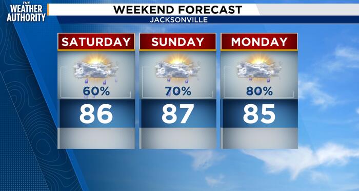
Jacksonville is heading into a prolonged period of warm, humid, and increasingly unsettled weather. Today, Friday, October 2, will be hot and muggy, with temperatures reaching around 88°F and numerous showers and thunderstorms developing from late morning through the afternoon and evening. The east-coast sea breeze will help trigger storms inland, and some thunderstorms could produce frequent lightning, gusty winds, and very heavy downpours. Saturday should remain similarly warm and humid, with highs in the mid to upper 80s and numerous showers and thunderstorms. Rain could become particularly heavy at times as increasing tropical moisture interacts with a developing frontal boundary. By Sunday, the weather becomes even more unsettled, with repeated rounds of showers and thunderstorms possible throughout the day. The National Weather Service is particularly concerned about locally heavy rainfall during this period, and areas that receive multiple downpours could begin experiencing localized flooding. Stronger thunderstorms could also produce gusty winds and frequent lightning.
Monday is expected to remain wet and stormy, with the frontal boundary lingering near the region and providing additional opportunities for showers and thunderstorms. At the same time, the weather pattern should begin changing as high pressure builds north of Florida. Northeast winds are expected to strengthen Monday night, setting up a significantly different pattern for Tuesday and Wednesday. By Tuesday, Jacksonville could see a combination of continued rain, strong northeast winds, rough surf, and dangerous rip currents. The strengthening pressure gradient may produce wind-advisory-level conditions along portions of the coast, while gale-force gusts could occur over the Atlantic waters. The stronger onshore flow will also increase the potential for beach erosion and tidal flooding, particularly around times of high tide.
Wednesday is expected to remain windy and unsettled, with strong northeast winds continuing and additional showers or thunderstorms possible as the frontal boundary remains nearby. Coastal areas will likely continue dealing with rough surf, dangerous rip currents, and elevated tidal flooding concerns. Temperatures should begin trending downward compared with the warmer conditions earlier in the week as cooler air filters southward. By Thursday, the weather may begin transitioning toward a cooler pattern as high pressure pushes the frontal boundary south of the area. However, showers and thunderstorms could still occur, particularly early in the day, and the exact timing of the transition remains uncertain.
Overall, the most notable feature of the upcoming week is the extended period of moisture and rainfall followed by a sharp increase in northeast winds and coastal hazards. Friday through Monday look increasingly wet, with the greatest concern being repeated heavy thunderstorms and localized flooding. Tuesday through Thursday shift the focus toward strong northeast winds, rough Atlantic conditions, dangerous surf and rip currents, beach erosion, and possible tidal flooding. Temperatures should start out near the upper 80s but trend cooler later in the week as the frontal boundary moves south and a stronger area of high pressure builds in.
Copyright 2026 by WJXT News4JAX – All rights reserved.