
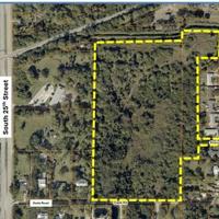
FORT PIERCE – The City Planning Board voted unanimously Sept. 17 to recommend the City Commission rezone a 22-acre parcel north of Dade Road and west of Sunrise Boulevard to planned development for the construction of a fee-simple townhome development on a site previously approved for rental apartments.
Senior Planner Vennis Gilmore introduced the agenda item that evening.
“Before you we have the zoning atlas map amendment for the Privilege-Sunrise Boulevard Planned Development located at 3315 Sunrise Boulevard,” he said. “The applicant is proposing a 184-unit townhome development with a recreational area, pool, 508 square foot, hurricane- hardened pool cabana and associated site improvements. Right-of-way dedications will be required as part of developmental approval and are noted in the attached plan.”
Gilmore acknowledged that the property currently held approval for a 216-unit apartment complex and that the newest owner of the property has decided to create townhomes instead. The applicant is now requesting a change from R-4 Zoning to planned development to alter the lot sizes and create more open space. He compared the minimum requirements of both zoning categories.
“Under R-4, the lot width would be 16 feet for the townhomes,” he explained. “This parcel is proposing 20-foot lot width. The maximum lot width is 24; the project is proposing 45 feet. The minimum front setback is 10 for R-4; the applicant is proposing 25. The maximum allowed building height in R-4 is 45 feet; the applicant’s proposing 30. The maximum building coverage is 50 [percent]; the applicant is proposing 20.45. The minimum open space required is 20 [percent]; the applicant is proposing 35.”
Gilmore then enumerated the PD benefits the developer would provide, which include larger landscape buffers, a15-foot right of way dedication on Dade Road, sidewalks on both sides of the internal private roads and an ingress/egress easement on the northeast corner of the property to allow access for a land-locked parcel.
“The project would incorporate rain gardens throughout the site to improve stormwater runoff, promote groundwater recharge and enhance the site’s overall environmental performance,” he continued. “The applicant will reduce the density from 218 to 184, [which] has lightened the impacts on public facilities, transportation networks and surrounding neighborhoods. The applicant is also constructing internal roads, utilities and drainage to serve the development.”
After Gilmore recommended approval dependent on 11 conditions, the applicant’s contracted Landscape Architect Brad Currie provided his own presentation.
“The request is for approval of a 181-lot townhome development,” he said. “I think staff said 184, but the newest plan is 181. We meet or exceed most of the R-4 criteria in the PD, and I’m sure most of you up are asking yourself why didn’t Brad just do a straight zoning district. The answer is the right of way. The city requires us to have a big, wide right of way, typically 50 or 60 feet. This is a pretty small development for what we deal with in our business. We really wanted a tighter right of way and think it results in an overall better community.”
Currie also pointed out a couple more public benefits, including turn lanes on Sunrise Boulevard – that the developer is voluntarily constructing – and an agreement with adjacent homeowners to create catch basins and receive their stormwater into his projects retention pond.
“We have already done the civil plans and feel like we can accommodate what we call historical drainage that comes off those folks’ properties to the east of us,” he said. “We’re going to dedicate 15 feet to Dade Road. The Engineering Department dug their heels in, forcing us to build that sidewalk there. It’s kind of a sidewalk to nowhere, but we are constructing a sidewalk along Dade Road. We’re doing the same thing on Sunrise with a small 15-foot right of way along our frontage to the county.”
Board Member Johanna Gromek then peppered Currie with a variety of questions, focusing first on the small wetland in the center of the property.
“I noticed that there was a wetland mitigation,” she said. “Is that completed yet?”
“Yes ma’am it was,” Currie responded. “The earlier approval had full construction plans back in 2006. That client at that time – whom I worked for to get the apartment plan approved – had it ready to go. The economy fell apart and they weren’t able to move forward, [but] he actually paid the money to the mitigation bank. My professional staff says that, while there may be wetlands there, they’ve been mitigated for and therefore no longer exist.”
Board Member Gromek also worried about the potential traffic impacts.
“I noticed a lot of these reports are a year old, but within the last year alone, we have had an increase in population,” she said. How does that change? I understand you’re doing things in a timeframe as well.”
“We look at what’s happening in the area, and this is kind of an established, older portion of the city,” Currie explained. “I can’t think of another project that’s been approved in the last year in this general area. Most of this stuff has been established for quite some time.”
After Currie described the mandatory methodology review process with St. Lucie County, its Transportation Planning Organization and the county’s incorporated cities that’s needed to conduct a traffic study, Board Member Colby Johnson posed a clarification question.
“When you submit the information to the [TPO] board you mentioned, is that like a collective for other traffic studies that all share their information for on-boarding properties?” he asked.
The applicant’s contracted Traffic Engineer Shaun MacKenzie tackled that inquiry.
“I wish there were a database like that – that would make my life a lot easier,” he said. “I’m constantly reaching out to the city and the county and the TPO, looking through your Planning Board notes and the county’s planning board notes and the City of Port St. Lucie’s notes and downloading every bit of information I can to get the most current data into the study.”
A trio of public speakers followed MacKenzie to the podium, each expressing concerns about traffic and a lack of sidewalks in the area. When Sunrise Boulevard resident Carl Schaffer insisted that children attending the three nearby schools on South 25th Street would be walking next to traffic on Dade Road as a short-cut, Currie reminded him of his client’s obligation.
“Dade Road is a substandard roadway and there’s not enough right of way to do a sidewalk,” he said. “So we are proposing to build sidewalk along our portion of it. Unfortunately, we don’t have the ability to control going all the way out to 25th Street. If you were to expand Dade Road, you might have to do imminent domain and take peoples’ houses.”
For his part, Dade Road resident Richard Tremblay worried about the location of the emergency access near his home and asked about relocating it.
“If you’re standing in my driveway, it’s right there, and I have six-year-old grandson who loves to ride his bike up and down our driveway,” he said. “If we get all these vehicles out there, I’m very, very concerned. Would it be possible to just move that to the southwest corner in line with the existing road that’s already there? You’d just have to put that through to Dade Road, and it’d be away from my driveway and my grandson.”
After a brief final discussion, the Planning Board voted unanimously to recommend approval of the rezoning to the Fort Pierce City Commission.