
Tampa Bay skies are likely to be gray and dreary this week as a cold front stalls over the state, leading to days of rainy weather.
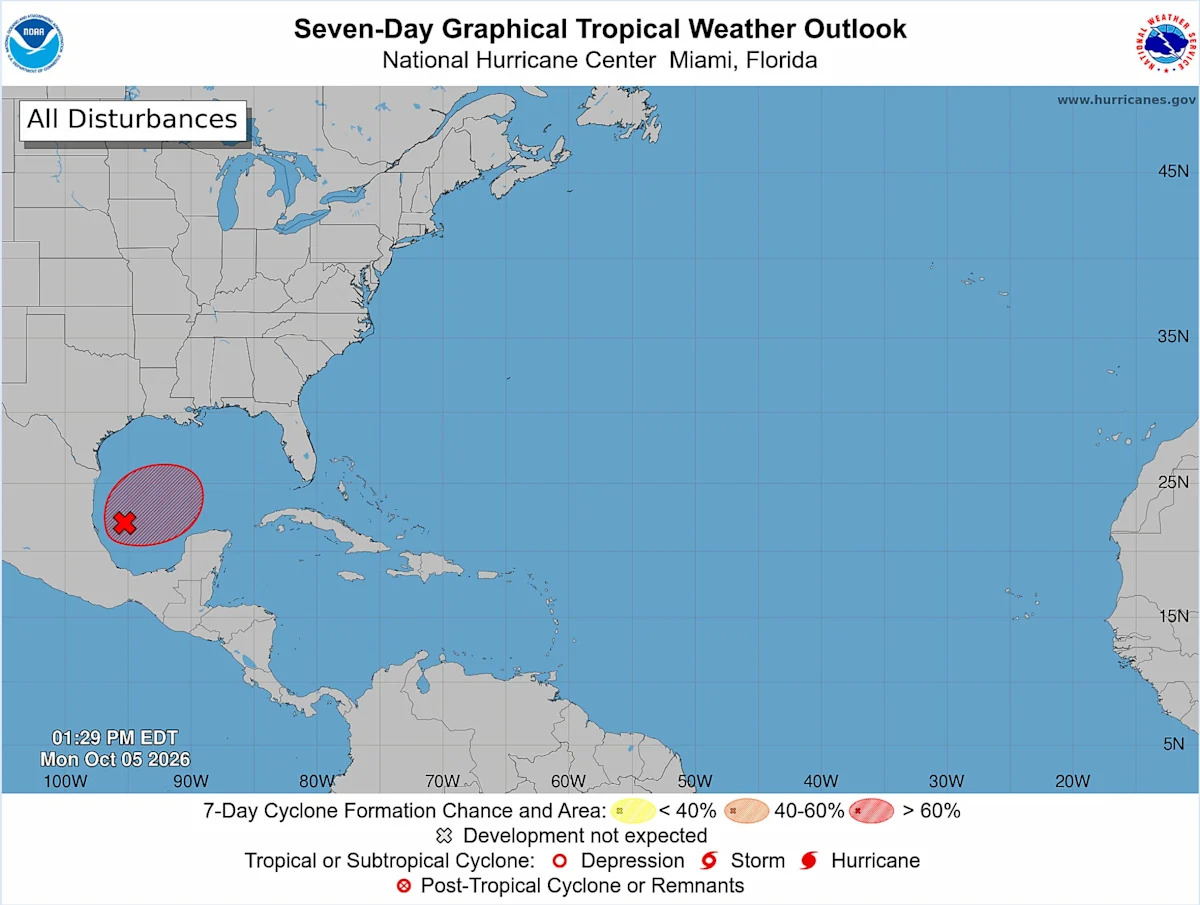
Elsewhere, forecasters are monitoring a system near Mexico that is expected become a tropical depression as it moves east this week.
Meteorologists and forecasters say it’s too early to know where the system may end up or how strong it may be.
Gulf Coast residents from Louisiana to Florida should watch the forecasts “for the possibility of anything from a sloppy rainmaker to a more coherent wind, rain, and surge threat later this week into the weekend,” wrote Michael Lowry, a South Florida hurricane specialist, in a post on his “Eye on the Tropics” Substack.
Early Monday, a cold front was spurring on showers and thunderstorms along the Panhandle. The National Weather Service expects that front to sag slowly intomuch of the rest of Florida and park there.
Floridians should not expect chillier weather with this cold front. Instead, gray skies and humidity will blanket Tampa Bay.
“It’s going to bring an increase — I know it’s hard to believe in Florida — but an increase in moisture and humidity,” said Stephen Shiveley, a meteorologist for the National Weather Service in Ruskin.
The Weather Prediction Center issued a marginal risk of excessive rainfall through Thursday across Florida, which includes much of Tampa Bay. The threat migrates south as the week progresses.
The overcast skies will keep temperatures in the mid-80s, but muggy weather will persist.
Shiveley said showers are likely to be on and off over the next several days. Wednesday and Thursday will likely be the dreariest, he said.
The Nature Coast could see rain totals topping out at around 6 inches this week. Tampa Bay can expect 2 to 4 inches, Shiveley said.

A forecast from the National Weather Service shows up to 4 inches of rain could fall in Tampa Bay over the next week.
Florida typically dips its toes into fall around early October, but it’s still difficult for cold fronts to keep up steam when diving into the state.
“We get these dying cold fronts that just don’t have the energy yet to push through us, and they end up being kind of like a graveyard here in Florida,” Shiveley said.
Florida cold fronts may struggle in early October, but tropical weather still has some juice left this time of year.
The National Hurricane Center was eyeing that southwestern Gulf system Monday and said it was producing disorganized showers and thunderstorms.
Forecasters say it is likely to develop gradually and will likely become a tropical depression during the middle or latter part of this week.
The hurricane center said the system should drift east for the next few days before turning north.
“It is too early to determine the specific impacts to the northern Gulf Coast, but interests there should closely monitor the progress of this system,” forecasters wrote Monday in a tropical update.
Forecasters gave the system a 60% chance of development over the next two days, and an 80% chance in a week.
“It seems likely a system will develop, but it also seems likely it will struggle to get strong due to wind shear,” Jeff Berardelli, chief meteorologist for News Channel 8, wrote Monday morning in a social media post.
No hurricanes have formed this season in what has become an unprecedented stretch of calm not seen since satellite tracking began 60 years ago.
A robust El Niño has ramped up strong, widespread wind shear that has curbed any chances of storms developing further.
“If a system manages to get going, steering currents would favor a generally northward track,” Paul Dellegatto, chief meteorologist for Fox 13, wrote in a social media post Sunday.
“Regardless of whether a named storm forms, one thing is certain: elevated rain chances and above-normal rainfall will persist through mid-October.”
Models largely agree that a “plume of moisture” associated with the system will move north toward Louisiana to the Panhandle, whether the disturbance develops or not, Shiveley said. As of Monday, Shiveley said no reliable model runs that he had seen show the system near Tampa Bay.
He added that models struggle to track storms before they have developed.
For now, the system is still several days out. Any effects from it likely wouldn’t arrive until the weekend or early next week.
“Right now the general thinking is a weaker storm or low pressure,” Denis Phillips, chief meteorologist for Tampa Bay 28, wrote in a social media post Monday morning. “The main threat will be heavy rain as this interacts with a front along the northern Gulf Coast.”
• • •
Tampa Bay Times 2026 hurricane guide
The 2026 hurricane season is here. Here’s what the forecasts say
What is a ‘super El Niño’? And what does it mean for hurricanes in Florida?
What to know about river flooding in Tampa Bay this hurricane season
Hurricane forecasts are overwhelming. Here’s how to read them
What should you pack in your storm kit? Here’s where to start
Get Times storm alerts on all your devices
How Tampa Bay seniors, others can get help evacuating
How to handle fires, tree limbs and other hazards after a storm
Here are the lessons you learned from Tampa Bay’s historic 2024 hurricane season