
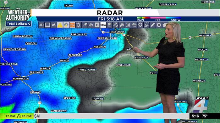
We’re starting today with a very active weather pattern across Northeast Florida and Southeast Georgia. Persistent onshore flow continues this morning, and that will keep coastal and river flooding concerns in place, especially around times of high tide.
A Coastal Flood Warning remains in effect for the St. Johns River basin, including downtown Jacksonville southward toward Lake George, through Thursday afternoon. Coastal Flood Advisories also continue for the Atlantic coast and Intracoastal Waterway through Saturday.
Today will be cloudy, breezy, and wet at times. Showers and thunderstorms are likely through the day, especially before 4 p.m., with another round possible late this afternoon into the evening.
Rain chances are around 90%, and while most rainfall totals should stay in the quarter- to half-inch range, heavier pockets will be possible under thunderstorms.
Winds will be out of the east around 13 to 16 mph, with gusts up to 28 mph, so it will feel raw, damp, and unsettled near the coast.
Tonight, showers and a few thunderstorms remain likely, mainly before midnight, then coverage becomes more scattered overnight. Lows will stay mild near 75 degrees with continued breezy east winds.
Additional rainfall will generally be light to moderate, but any stronger storms could produce locally higher totals.
Saturday is the day we’ll need to watch more closely. The environment becomes more favorable for isolated strong to severe thunderstorms, potentially beginning before sunrise and continuing through the day.
The main concern will be damaging wind gusts, but a brief tornado cannot be ruled out. The highest tornado potential looks to be across the Suwannee Valley and inland Southeast Georgia, but we’ll need to monitor the entire area as storms develop.
Saturday will also be warmer and humid, with highs near 89 and heat index values possibly near 100. Rain and storm chances are around 60%, especially later in the day and into Saturday evening.
This setup is tied into Hurricane Isaias, which is expected to bring significant impacts to the Gulf Coast and inland Southeast.
The worst of the hurricane conditions stay well west of Jacksonville, but we are still dealing with the indirect impacts: increased moisture, breezy onshore flow, elevated coastal water levels, dangerous surf/rip currents, and a more unstable environment for storms Saturday.
By Sunday, conditions begin to improve. We’ll still keep a 30% chance of showers and thunderstorms, mainly between 8 a.m. and 2 p.m., but the overall trend is quieter. Highs will be in the upper 80s. Sunday night turns partly cloudy and noticeably more comfortable, with lows near 68.
Early next week looks much better. Monday through Wednesday should bring mostly sunny skies, lower rain chances, and highs near 87. Overnight lows will fall into the mid to upper 60s, giving us a little taste of a cleaner, calmer pattern after several messy days.
Copyright 2026 by WJXT News4JAX – All rights reserved.