
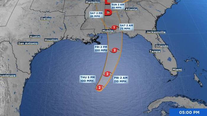
Isaias, the first hurricane of the Atlantic season, strengthened on Thursday as it barreled toward landfall late Friday or early Saturday along the northern Gulf Coast.
As of 9 p.m. Thursday, the system now has maximum sustained winds of 100 mph, and additional strengthening is expected through early Friday.
Hurricane Isaias has developed a visible eye on satellite imagery — a first for the 2026 Atlantic Hurricane Season — as the storm intensifies and turns toward the northeast ahead of an expected Gulf Coast landfall.
Storm strengthens as eye becomes visible
The eye of Isaias became apparent on both visible and infrared satellite imagery, marking the first eye observed on satellite pictures in the Atlantic basin this hurricane season. While cloud tops have mostly warmed within the system, the latest subjective Dvorak classification value from the Tropical Analysis and Forecast Branch, known as TAFB, has increased to T4.5, or 77 knots.
NOAA Hurricane Hunter aircraft observations have not yet indicated a drop in central pressure, and peak 700-millibar flight-level winds have not increased. However, Tail Doppler Radar wind velocities measured just above the surface support raising the storm’s intensity to 85 knots for this advisory.
Track shifts northeast toward Gulf Coast
Satellite and aircraft center fixes confirm Isaias has made its expected turn toward the northeast, with an initial motion now recorded at 050/10 knots. The storm is expected to turn northward and move between a mid-level ridge extending westward from the Bahamas to the Florida peninsula and a trough near the northwest Gulf Coast.
On the forecast track, the center is expected to move inland along the northern Gulf Coast within the next 36 hours, then pass over portions of the southeastern United States over the following few days. The official forecast has been nudged slightly eastward in line with the latest corrected consensus model guidance.
Intensity forecast complicated by competing conditions
The intensity forecast remains somewhat uncertain as Isaias approaches land. The hurricane will be passing over Gulf waters with high oceanic heat content over the next day or so, including a projected path near a warm eddy overnight — conditions that could fuel further strengthening.
However, vertical wind shear, already significant, is expected to increase substantially over the next 36 hours. Forecasters believe the shear will not offset the favorable oceanic conditions for another 12 to 24 hours, meaning further strengthening is anticipated overnight. The official intensity forecast sits at the high end of model guidance, with some decrease in intensity expected in the 24-to-36-hour window as Isaias approaches the coast.
Regardless of exact intensity at landfall, Isaias is expected to remain a dangerous hurricane. Strong, gusty winds are expected well inland after the center crosses the coast.
Life-threatening storm surge threatens Gulf Coast
A life-threatening storm surge is expected from the Mouth of the Mississippi River to Suwannee, Florida. Residents in the warning area should follow the advice of local officials and evacuate immediately if ordered to do so.
Hurricane-force winds expected across Florida Panhandle, Alabama, Mississippi
Damaging, hurricane-force winds are expected over portions of the Florida Panhandle, southern Alabama and southern Mississippi, where a Hurricane Warning is in effect. Residents in these areas should prepare for the possibility of long-duration power outages.
Damaging wind gusts are also possible over much of central and northern Alabama, extreme eastern Mississippi and portions of western and northern Georgia — especially in areas of higher terrain. Additional Tropical Storm and High Wind Watches and Warnings may be issued for portions of those areas later tonight.
Residents in affected areas are urged to secure loose outdoor items, avoid driving high-profile vehicles and prepare for power outages.
Heavy rainfall, flooding to impact Southeast through weekend
Isaias is expected to bring areas of heavy rainfall to the central U.S. Gulf Coast and much of the Southeast on Friday into the weekend. Considerable flash flooding and urban flooding, along with significant river flooding, will be possible.
Residents across the region should monitor local forecasts and be prepared to act quickly if flood warnings are issued in their area.
Residents are encouraged to monitor updates from the National Hurricane Center at nhc.noaa.gov and follow guidance from local emergency management officials.
Copyright 2026 by WJXT News4JAX – All rights reserved.