
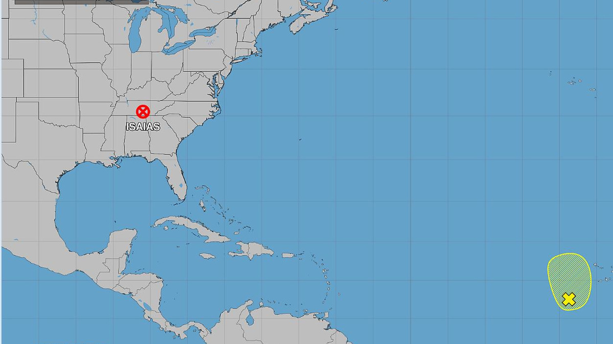
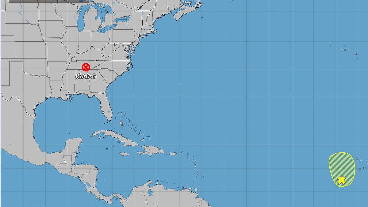
According to the 8 a.m. Sunday, Oct. 11, 2026, tropical weather outlook from the National Hurricane Center in Miami, Florida, Post-Tropical Cyclone Isaias was expected to bring flash flooding as it heads northeast, and there was a disturbance with 20% chance of formation in the Atlantic (shown in yellow).
GRAPHIC PROVIDED BY NATIONAL HUR
USA TODAY Network, Reuters
Isaias is still hanging around, and there’s a new tropical disturbance in the Atlantic.
After a “quiet” summer, the first storm of the 2026 Atlantic hurricane season made landfall in Destin, Florida, as a Category 2 with 105 mph winds − then it quickly weakened as it continued to move northeast. As of Sunday, Oct. 11, 2026, the storm was responsible for four deaths, two in Escambia County, Florida, and two in Alabama.
The 8 a.m. Sunday tropical weather outlook from the National Hurricane Center in Florida states “Post-Tropical Cyclone Isaias” was expected to bring flash flooding to the northeast, and there was a disturbance with 20% chance of formation in the Atlantic. Where is Isaias? The hurricane center’s weather prediction center is issuing advisories on Post-Tropical Cyclone Isaias, which was located near the border of Tennessee and Kentucky.
The former Category 3 hurricane officially formed as a tropical storm and hurricane Oct. 7, with landfall in the Gulf Coast on Oct. 9.
In addition, the hurricane center reported about an elongated area of low pressure centered a few hundred miles southwest of the Cabo Verde Islands. Formation chance through 2 days remains low at 20%.
Forecasters also are monitoring three tropical waves in the Atlantic.
➤ Track all active storms
Isaias was briefly a tropical storm before strengthening into hurricane status hours later on Wednesday, Oct. 7, 2026. The storm made landfall about 8:30 p.m. CT Friday, Oct. 9, 2026, in Destin, Florida, as a Category 2 storm with 105 mph winds and had been downgraded by 4 a.m. Saturday, Oct. 10, 2026.
Isaias peaked at 120 mph, dropped to 105 mph at landfall in the Florida Panhandle.
There have been no other named storms so far into the fifth month of the 2026 Atlantic hurricane season.
The hurricane center graphics and live weather radars below show what’s swirling in the tropics (if anything) as well as the conditions for potential rain, flash flood and other warnings.
Atlantic hurricane season is from June 1 to Nov. 30 every year, with the most activity between August and October. Should a weather system develop into a tropical storm, the 10th system would be named Josephine, shown on the list of the 2026 Atlantic hurricane season names below.
➤ Weather alerts via text: Sign up to get updates about current storms and weather events by location
Keep reading for information about tropical storm activity and updates about Isaias for Sunday, Oct. 11, 2026.
National Hurricane Center in Miami, Florida, forecast on tropical activity: Where is Isaias?
According to the 8 a.m. Sunday, Oct. 11, 2026, tropical weather outlook from the National Hurricane Center in Miami, Florida, the weather prediction center was issuing advisories on Post-Tropical Cyclone Isaias, located near the border of Tennessee and Kentucky. In addition, there is a tropical disturbance in the Atlantic with a low chance of formation.
The NHC reports:
Eastern Tropical Atlantic (shown in yellow): An elongated area of low pressure centered a few hundred miles southwest of the Cabo Verde Islands is producing a large but disorganized area of showers and thunderstorms extending from these islands southward into the eastern Tropical Atlantic. Environmental conditions appear only marginally conducive for some development of this system over the next day or two before upper-level winds become too strong for development by midweek. Regardless of development, heavy rainfall will be possible during the next few days over portions of the Cabo Verde Islands as the system moves slowly northward to north-northwestward.
Formation chance through 7 days was low at 20 percent.Formation chance through 48 hours was low at 20 percent.
The graphic above automatically updates with the most recent location for any or all disturbances. The NHC also reported it is monitoring three tropical waves:
An eastern Atlantic tropical wave was along 29W, south of 19N, moving westward at 10-15 knots. A 1011 mb low pressure was analyzed along the wave and monsoon trough near 13N27W. The broad system was producing a large area of showers and thunderstorms, mainly from 06N to 17N and between 22W and 36W.Another eastern Atlantic tropical wave was along 38W, south of 19N, moving westward at 10-15 knots. Scattered moderate to isolated strong convection was observed from 08N to 17N and between 33W and 45W.A western Caribbean tropical wave was along 88W, south of 19N, moving westward at 10-15 knots. The wave continues to interact with an upper-level low over the NW Caribbean, and was supporting scattered moderate to isolated strong convection over much of the NW Caribbean.
The Atlantic basin consists of the northern Atlantic, Caribbean Sea and Gulf of America. NOAA changed its naming convention for the Gulf of Mexico after the U.S. Geological Survey changed the name on U.S. maps per President Trump’s order.
The USA TODAY Network in Florida will produce daily tropics watch advisories.
2026 Atlantic hurricane season predictions
Is it raining in Florida today? Live weather radar
Shown is the National Weather Service radar, which shows conditions in real-time for the Southeast United States and parts of Central Florida. The current date and time show up on the bottom right of this radar embed; otherwise, you may need to clear your cache.
Weather watches and warnings issued in Florida
What are the 2026 Atlantic hurricane season names? Did your name make the hurricane season names list?
Since 1953, the National Hurricane Center has released a list of names in alphabetical order for Atlantic tropical storms before each season begins, which it recycles every six years. It retires names of storms that are excessively deadly or costly, if it would be insensitive or inappropriate to use them again. These are the 2026 Atlantic tropical cyclone names:
Arthur, which formed as a tropical storm June 17, 2026Bertha, which formed as a tropical storm July 20, 2026Cristobal, which formed as a tropical storm Aug. 12, 2026Dolly, which formed as a tropical storm Aug. 27, 2026Edouard, which formed as a tropical storm Sept. 1, 2026Fay, which formed as a tropical storm Sept. 20, Sept. 23, and Sept. 28Gonzalo, which formed as a tropical storm Sept. 24Hanna, which formed as a tropical storm Sept. 28Isaias, which formed as a tropical storm Oct. 7 and hours later strengthened into a hurricane, making landfall in Destin, Florida, on Oct. 9JosephineKyleLeahMarcoNanaOmarPauletteReneSallyTeddyVickyWilfred
Stay informed. Get weather alerts via text
What’s next?
We will provided tropical weather coverage daily until Nov. 30 to keep you informed and prepared. Download your local site’s app to ensure you’re always connected to the news. And look for our special subscription offers here.
Contributing: Cheryl McCloud and Olivia Franklin, USA TODAY Network-Florida
This article originally appeared on Pensacola News Journal: After Isaias, hurricane center in Florida tracking disturbance in Atlantic
Reporting by Jennifer Sangalang, USA TODAY NETWORK – Florida / Pensacola News Journal
USA TODAY Network via Reuters Connect
Copyright Reuters or USA Today Network via Reuters Connect
This story was originally published October 11, 2026 at 9:53 AM.