
JACKSONVILLE, Fla. – This morning was the coldest morning of the year and for that matter the coldest November morning since 2014! Let’s break down some of the records set along with the potential for another freeze tonight.
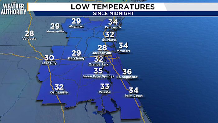
Under a clear sky and light wind, temperatures plummeted this morning. Several spots reported lows in the 20s, and that’s without the wind chill. Jacksonville International Airport set a new record low of 28 degrees. This shattered the previous record of 35 degrees set in 1977. It is the coldest November morning at JAX in over 25 years.
Jacksonville Executive at Craig Airport also set a new record low of 33 degrees. The prior record was 37 degrees set in 1991.
With temperatures below freezing this morning at JAX, it’s the fourth earliest freeze since records have been recorded in the Jacksonville area (1871).
Lowest wind chill reports.
Wind chill values Tuesday morning dropped into the low 20s for many locations. JAX recorded a wind chill of 21 degrees. This is lowest wind chill value recorded in the month of November since 2014.
Frost/Freeze alerts are in effect tonight.
Another freeze is likely overnight for many locations. A Frost Advisory and a Freeze Warning is in effect for our area. Make sure to take protective measures if you have outdoor plants.
Tonight’s low temperatures.
Temperatures will drop into the 20s and 30s for many locations. The record low at JAX is 31 degrees set in 2011.
The cold air will be short-lived. Temperatures will climb to near 80 degrees later this week and overnight temperatures will eventually be near 50 degrees.
Copyright 2025 by WJXT News4JAX – All rights reserved.