
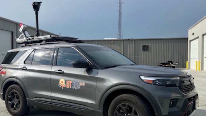
SEMINOLE COUNTY, Fla. – If you’ve spotted a car with cameras mounted on top driving through your neighborhood lately, it’s not from Google Maps. It’s part of a new statewide effort to prepare for natural disasters before they strike.
The high-tech vehicle, operated by the company DebrisTech, is scanning and mapping every mile of roadway and bridges across Florida. County officials said the goal is to document current conditions, creating a “before” picture that can be compared to damage after hurricanes or floods.
“This vehicle takes scans of the roadways, the bridges, all throughout the entire state of Florida,” said Alan Harris, director of Seminole County Emergency Management. “It helps us with damage assessment immediately after a disaster. Now we’re going to have pre-disaster pictures as well as post-disaster pictures.”
[VIDEO: Seminole County schools residents about new public transit system dubbed SCOUT]
[EXCLUSIVE: Become a News 6 Insider (it’s FREE) | PINIT! Share your photos]
The project is being funded through a partnership among Florida counties, including Seminole, and federal disaster recovery programs. Using LiDAR technology — laser-based scanning that measures distances — the DebrisTech vehicle creates detailed three-dimensional models of the environment.
Officials say the scans serve multiple purposes: they can help with hurricane recovery, identify infrastructure issues before they worsen, and provide critical evidence when working with FEMA or insurance agencies after a storm.
“Immediately after the disaster, we can show what it looked like before and what it looks like now,” Harris said. “It’s very clear for FEMA, insurance agents, or whoever we need to present it to.”
[VIDEO: Seminole County homeowners concerned about homes after leaders approve connector]
Although the vehicle may drive past homes or flood-prone areas, Harris emphasized it’s not being used for surveillance. Seminole County notifies 911 centers, city managers, and first responders before scans take place.
“The goal is mapping flood risks, not invading privacy,” Harris said.
The information gathered is also being used for routine roadwork and infrastructure upgrades. Harris said the county uses the data to plan “road mitigations” — improvements like elevating vulnerable streets, adding stormwater protections, or resurfacing heavily trafficked areas.
“It’s good for government, it’s good for the roadways, and it’s good for your traveling,” he said. “This is going to help improve our roadways, help us mitigate, and help us be prepared for future hurricanes.”
Officials expect the statewide scanning project to wrap up by mid-November.
Breaking News Alerts
Get breaking news alerts delivered to your inbox.
Copyright 2025 by WKMG ClickOrlando – All rights reserved.