
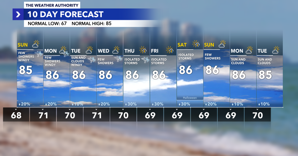
Southwest Florida is heading into a windy stretch to start the week, with gusts potentially topping 35 mph Sunday and Monday. Temperatures will remain near normal, while a few showers are possible Sunday before additional rain chances return later in the week.
Windy Weather Continues Tonight
Overnight temperatures will settle into the upper 60s to around 70 degrees, with mostly clear skies and a cool breeze. Northeast winds of 10 to 15 mph will continue into Sunday morning.

Boaters should prepare for rough conditions. A Small Craft Advisory is in effect for local coastal waters through Wednesday evening. Northeast winds of 20 to 30 knots and Gulf wave heights of 3 to 5 feet are expected offshore, with rough conditions also possible across local bays.
Sunday: Few Showers and Gusty Winds
Sunday will bring a mix of sunshine and clouds, a few showers and gusty northeast winds. High temperatures will reach the middle 80s, near the seasonal average of 85 degrees.
Scattered showers and a few storms are expected to develop over the Gulf Stream and Southeast Florida. Some of this activity could drift inland, but showers are forecast to weaken as they move toward Southwest Florida. Most communities should see limited rainfall, with plenty of dry time throughout the day.
The bigger story will be the wind. Sustained northeast winds of 15 to 25 mph are expected, with gusts exceeding 35 mph possible. Coastal communities and locations near the water could experience the strongest gusts.
These winds may blow around unsecured outdoor decorations and furniture and create difficult conditions for high-profile vehicles. Boaters should use extra caution, as choppy waters and rough conditions are expected.
Monday and Tuesday: Another Windy Day Before Conditions Gradually Improve
Monday will remain windy, with a few showers possible and highs near 86 degrees. Northeast winds will remain strong, with gusts potentially exceeding 35 mph again.
Winds will begin to ease Tuesday, although it will still be breezy at times. Sunshine and clouds will mix throughout the day, with temperatures climbing into the middle 80s.
The persistent wind is being driven by the pressure difference between high pressure to our north and the lingering frontal boundary farther south. As the upper-level low pressure system north of the Bahamas slowly moves northeast, the overall weather pattern will begin to change.
Midweek: Winds Ease, but a Few Showers Return
By Wednesday, winds should be noticeably lighter compared with the start of the week. High temperatures will remain near 86 degrees, with a few showers possible.
Rain chances increase slightly Thursday and Friday, when isolated storms are possible. The forecast currently calls for a 30% chance of rain each day, meaning most locations should remain dry, but a few passing showers or storms could develop.
Despite the occasional rain chance, temperatures will remain warm and fairly consistent. Afternoon highs will stay in the middle 80s, while overnight lows settle into the upper 60s to lower 70s.
Halloween Weekend: Warm With Spotty Rain Chances
Looking ahead to Halloween weekend, temperatures will remain near seasonal averages, with highs around 86 degrees and overnight lows near 69 degrees.
Saturday, October 31, carries a 30% chance of isolated storms. A few showers could affect outdoor Halloween plans, but widespread rainfall is not currently expected. Rain chances decrease to 20% Sunday, followed by just a 10% chance Monday and Tuesday as sunshine and clouds return.
It is still too early to pinpoint the timing of any showers on Halloween, so check back for updates as the weekend approaches.
Hurricane Season Countdown
There are just 37 days remaining in the 2026 Atlantic hurricane season, which officially ends November 30.
The latest tropical outlook shows no development expected over the next seven days. While the season is winding down, tropical systems can still develop before the official end of hurricane season.