
Christmas-like weather showed up unannounced this week, and it’s making an exit before the week concludes.
Cold records were broken across the state, including in Jacksonville, where temperatures plunged to 28 degrees Monday night into Tuesday morning, breaking the previous 1977 record of 35 degrees. The icy blast, driven by polar winds from the far north, proved intense but short-lived.
Following this morning’s freeze warning — which remained in effect across most of North Florida until 8 a.m., along with a frost advisory extending into Central Florida — temperatures are now expected to climb to a high of 68 degrees on Wednesday, Nov. 12. However, it’s not quite time to put away those plant covers just yet. Overnight lows in the Jacksonville area are expected to fall into the 40s, according to AccuWeather.
By Friday, we’ll be back to daytime temps in the high 70s and in the 80s over the weekend. Here’s what to expect in Jacksonville and the rest of Florida this week.
Jacksonville, Northeast Florida, saw record-breaking cold
A frost advisory is in effect until 8 a.m. ET for parts of coastal Northeast Florida.
What can Jacksonville expect tonight? Inland locations are expected to fall to the upper 30s and lower 40s, ranging to the mid and upper 40s for coastal northeast Florida. A few patches of frost may develop at normally colder inland locales, according to National Weather Service Jacksonville.
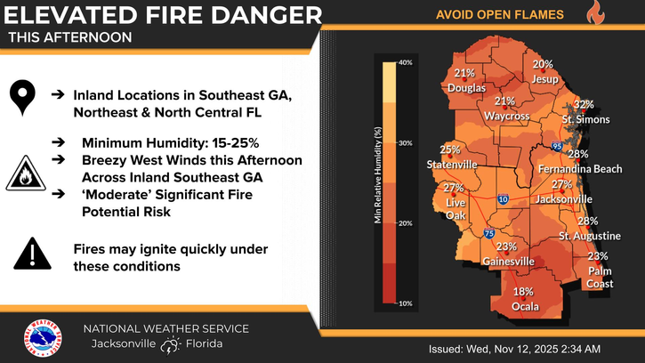
There is an elevated fire danger inland today due to critically low humidity values, breezy west winds and ongoing drought conditions.
Elevated fire danger in Southeast Georgia, Northeast and North Central Florida
As of 2 a.m. on Nov. 12, inland areas of southeast Georgia as well as northeast and north-central Florida, are under an elevated fire danger warning. A very dry air mass will persist across the region today, with inland humidity levels expected to drop to between 15 and 25 percent this afternoon. These extremely low humidity levels, combined with ongoing drought conditions and breezy westerly winds in inland parts of southeast Georgia, will contribute to an elevated fire risk throughout the day.

Elevated Fire Danger
What’s the weather in Jacksonville for this week?
Wednesday, Nov. 12: High 66; low 46
Thursday, Nov. 13: High 72; low 47
Friday, Nov. 14: High 74; low 50
Saturday, Nov. 15: High 77; low 54
Sunday, Nov. 16: High 78; low 57
Thursday morning temperatures across Florida: November 13, 2025
➤ Weather alerts via text: Sign up to get updates about current storms and weather events by location
Weather watches and warnings issued in FloridaWhat is a freeze warning? What is a freeze watch?
A Freeze Warning is issued when temperatures are forecasted to go below 32 degrees for a long period of time.
This temperature threshold kills some types of commercial crops and residential plants, while temperatures below 28 degrees for an extended period of time can kill most plants.
A Freeze Watch is issued when there is a potential for significant, widespread freezing temperatures within the next 24-36 hours. A Freeze Watch is issued in the autumn until the end of the growing season and in the spring at the start of the growing season.
Pensacola, Florida broke 99-year cold record Tuesday
Another clear, chilly night on tap with several spots around the area already falling to the freezing mark, according to National Weather Service Mobile. Patchy to areas of frost will develop overnight across inland communities.
Wednesday, Nov. 12: High 69; low 57
Thursday, Nov. 13: High 73; low 58
Friday, Nov. 14: High 73; low 59
Saturday, Nov. 15: High 73; low 64
Sunday, Nov. 16: High 75; low 63
Tallahassee, Florida, under freeze warning this morning
A freeze warning is in effect until 8 a.m. ET.
Highs today will push towards 70 degrees then beginning Thursday highs will reach towards the mid 70s with even a few 80s later in the weekend, according to National Weather Service Tallahassee. A backdoor cold front is expected to make a run towards north Florida Friday but should weaken and essentially wash out Saturday.
Wednesday, Nov. 12: High 69; low 47
Thursday, Nov. 13: High 74; low 47
Friday, Nov. 14: High 76; low 48
Saturday, Nov. 15: High 77; low 54
Sunday, Nov. 16: High 79; low 56
Daytona Beach, Florida to see warmer weather tonight
A frost advisory is in effect for Lake, Volusia, northwest Orange, western Seminole and northwest Brevard counties until 8 a.m. ET.
Highs reach the low to mid 70s on Thursday, with lows remaining a tad cooler in the mid 40s to mid 50s. Temperatures are then forecast to follow a gradual warming trend over the next several days, returning to near-normal temperatures by Friday, with highs in the mid 70s to low 80s with lows in the 50s to low 60s, according to the National Weather Service Melbourne.
Dry weather is forecast through the remainder of the week with a gradual warming trend into the weekend and early next week.
Wednesday, Nov. 12: High 68; low 50
Thursday, Nov. 13: High 71; low 55
Friday, Nov. 14: High 74; low 59
Saturday, Nov. 15: High 77; low 58
Sunday, Nov. 16: High 78; low 60
Melbourne, Florida lows tonight in mid-50s
A frost advisory is in effect for Lake, Volusia, northwest Orange, western Seminole and northwest Brevard counties until 8 a.m. ET.
Highs reach the low to mid 70s on Thursday, with lows remaining a tad cooler in the mid 40s to mid 50s. Temperatures are then forecast to follow a gradual warming trend over the next several days, returning to near-normal temperatures by Friday, with highs in the mid 70s to low 80s with lows in the 50s to low 60s, according to the National Weather Service Melbourne.
Dry weather is forecast through the remainder of the week with a gradual warming trend into the weekend and early next week.
Wednesday, Nov. 12: High 71; low 54
Thursday, Nov. 13: High 73; low 59
Friday, Nov. 14: High 77; low 64
Saturday, Nov. 15: High 78; low 61
Sunday, Nov. 16: High 81; low 62
Port St. Lucie, Florida back in the 70s today
A frost advisory is in effect for Lake, Volusia, northwest Orange, western Seminole and northwest Brevard counties until 8 a.m. ET.
Highs reach the low to mid 70s on Thursday, with lows remaining a tad cooler in the mid 40s to mid 50s. Temperatures are then forecast to follow a gradual warming trend over the next several days, returning to near-normal temperatures by Friday, with highs in the mid 70s to low 80s with lows in the 50s to low 60s, according to the National Weather Service Melbourne.
Dry weather is forecast through the remainder of the week with a gradual warming trend into the weekend and early next week.
Wednesday, Nov. 12: High 72; low 54
Thursday, Nov. 13: High 76; low 57
Friday, Nov. 14: High 79; low 61
Saturday, Nov. 15: High 80; low 60
Sunday, Nov. 16: High 81; low 61
Record low temps expected in West Palm Beach, Florida
Temperatures will cool slightly, remaining a few degrees below normal on the lows and highs through Thursday, according to National Weather Service Miami.
Hazardous marine and beach conditions will continue today while gradually improving.
Wednesday, Nov. 12: High 72; low 68
Thursday, Nov. 13: High 75; low 68
Friday, Nov. 14: High 77; low 71
Saturday, Nov. 15: High 77; low 70
Sunday, Nov. 16: High 79; low 69
Naples, Florida to see temps in high 40s
Temperatures will cool slightly, remaining a few degrees below normal on the lows and highs through Thursday, according to National Weather Service Miami.
Hazardous marine and beach conditions will continue today while gradually improving.
Wednesday, Nov. 12: High 77; Low 58
Thursday, Nov. 13: High 79; low 58
Friday, Nov. 14: High 80; low 61
Saturday, Nov. 15: High 80; low 64
Sunday, Nov. 16: High 80; low 65
Fort Myers, Florida could see more cold records broken today
Unseasonably cold conditions continue this morning with a few records lows again likely, according to National Weather Service Tampa Bay. Unlike Tuesday afternoon`s comparably impressive number of record low maximum temp records broken or tied, sunny skies today and lighter winds will allow afternoon temps to rebound rather impressively, with highs warming into the upper 60s to mid 70s.
Rain-free conditions and gradually warming temperatures expected remainder of the week and into the weekend.
Wednesday, Nov. 12: High 74; Low 53
Thursday, Nov. 13: High 77; low 53
Friday, Nov. 14: High 80; low 58
Saturday, Nov. 15: High 81; low 60
Sunday, Nov. 16: High 81; low 61
Lows could drop into 50s for several days in Sarasota, Florida
Unseasonably cold conditions continue this morning with a few records lows again likely, according to National Weather Service Tampa Bay. Unlike Tuesday afternoon`s comparably impressive number of record low maximum temp records broken or tied, sunny skies today and lighter winds will allow afternoon temps to rebound rather impressively, with highs warming into the upper 60s to mid 70s.
Rain-free conditions and gradually warming temperatures expected remainder of the week and into the weekend.
Wednesday, Nov. 12: High 70; Low 54
Thursday, Nov. 13: High 74; low 56
Friday, Nov. 14: High 76; low 59
Saturday, Nov. 15: High 76; low 62
Sunday, Nov. 16: High 76; low 64
Cold front could send temps into 40s in Orlando, Florida
A frost advisory is in effect for Lake, Volusia, northwest Orange, western Seminole and northwest Brevard counties until 8 a.m. ET.
Highs reach the low to mid 70s on Thursday, with lows remaining a tad cooler in the mid 40s to mid 50s. Temperatures are then forecast to follow a gradual warming trend over the next several days, returning to near-normal temperatures by Friday, with highs in the mid 70s to low 80s with lows in the 50s to low 60s, according to the National Weather Service Melbourne.
Dry weather is forecast through the remainder of the week with a gradual warming trend into the weekend and early next week.
Wednesday, Nov. 12: High 69; Low 47
Thursday, Nov. 13: High 73; low 50
Friday, Nov. 14: High 77; low 55
Saturday, Nov. 15: High 79; low 56
Sunday, Nov. 16: High 79; Low 58
Did it snow in Florida?
While it got cold, it didn’t get wet.
To get snow, you need moisture. Drought conditions across the state prevented the formation of any snow.
Has it ever snowed in Florida?
Yes, as recently as this year, in January.
Referred to as the 2025 Gulf Coast blizzard, the storm brought a record 8.9 inches of snow to Pensacola between Jan. 20-22, smashing the prior record of 3 inches set in February 1895.
Tallahassee recorded 1.9 inches, the second-highest amount on record, according to the National Weather Service.
A 200-mile section of Interstate 10 in the Panhandle was closed the day after snow fell.
Pensacola also saw a record low temperatures of 13 degrees on Jan. 22.
Florida weather radar for Nov. 12, 2025 Stay informed. Get weather alerts via textWhat’s next?
We will provide weather coverage as conditions warrant to keep you informed.
Download your local site’s app to ensure you’re always connected to the news. And look for our special subscription offers here.
This article originally appeared on Florida Times-Union: Freeze warning in Jacksonville. When will it get warm again this week?