
ORLANDO, Fla. – A quiet stretch of weather is holding on for the next few days across Central Florida, but changes are lining up post-Thanksgiving weekend.
Thursday-Saturday
A weak area of high pressure stays firmly in control, keeping things warm and dry.
Mornings may start with a bit of patchy fog thanks to light winds, clear skies and plenty of overnight humidity, but it should burn off quickly after sunrise.
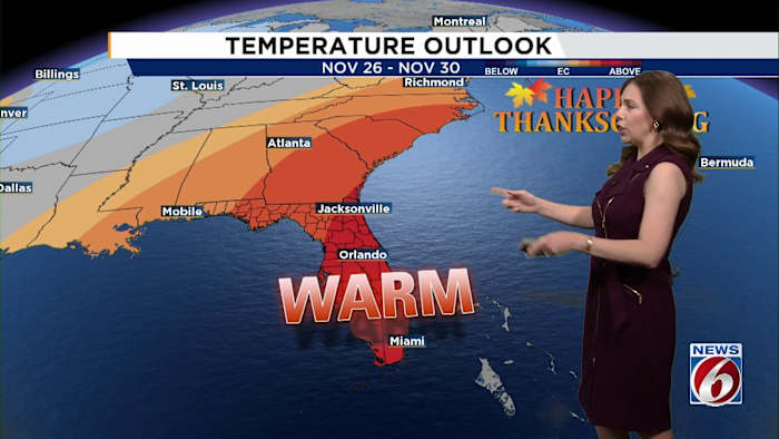
Temperatures will continue running warmer than normal, topping out in the low 80s along the coast and low to mid-80s inland.
The average high in Orlando for this time of year is 78 degrees.
[VIDEO BELOW: What’s going on with this weather change?]
Sunday-Wednesday
From Sunday through Wednesday, models agree on a weak front sliding through on Sunday. While it will shift winds back from the north, don’t expect big changes behind the system.
High pressure then shifts east over the Atlantic early next week, turning our winds back around to the southeast by Tuesday and even more southerly by Wednesday. That will keep temperatures running above normal, again in the low to mid-80s.
A few isolated showers may try to sneak in from the Atlantic on Tuesday or Wednesday, but most spots will stay dry.
[CRAZY VIDEO BELOW: Drone video of Hurricane Melissa]
Thanksgiving Day
Looking ahead to Thanksgiving, another cold front is forecast to approach, but there’s still plenty of uncertainty about timing and how quickly it moves.
As of Nov. 20, the early signs point to a mild to warm holiday with only small chances for scattered showers.
Post-Thanksgiving
There’s the potential for a stronger cold front to bring some cooler temperatures to Central Florida, but the timing and impacts are uncertain.
Check in with News 6 and ClickOrlando.com as we near the holiday.
Daily Forecast
The News 6 Weather team ensures you’re always on top of the day’s weather.
Copyright 2025 by WKMG ClickOrlando – All rights reserved.