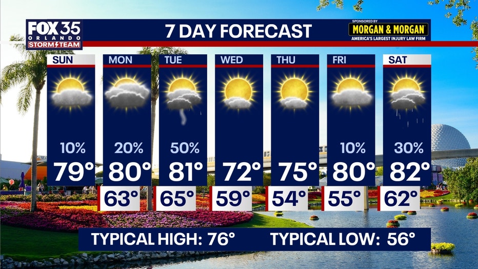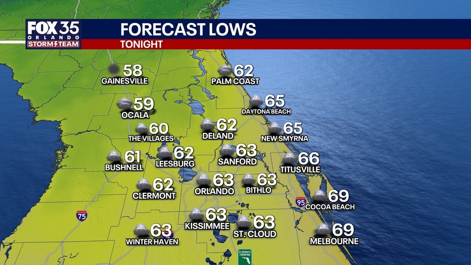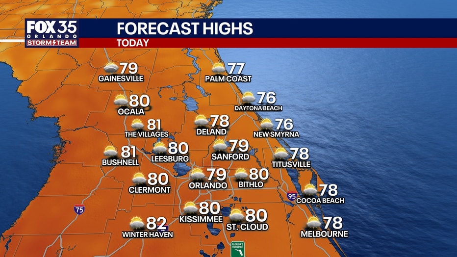
SUNDAY: The breeze continues to come in from the ENE on Sunday and that will keep the clouds around as well as a stray sprinkle or two. Afternoon readings will rebound even more so as this ridge of high pressure works eastward. This ridge allows our temps to climb back above average (76°) topping out close to 80 Sunday afternoon. Sunday night will be quiet but warmer, with a bit more cloud cover around. Lows only fall back into the low to mid-60s which is also above normal.MONDAY: The warming trend continues into early this week as another system develops to our west. Highs on Monday look to top out in the upper 70s and lower 80s under peeks of sun. Rain chances rise a touch as well as the onshore flow holds. Chances are low, near 20% to kick-off the workweek. It’ll be mainly dry and mild Monday night with lows well above normal. Readings only look to dip into the middle to upper 60s.LOOKING AHEAD: As this system works eastbound on Tuesday, it’ll bring a cold front slides our way. This is when we’ll see the highest rain chances developing, rising to 50%. Hit or miss showers and a few storms are on the table as this front works through Central Florida. On the backside of it, we’ll clear out midweek as drier air settles in. Temperatures drop back below normal, into the lower to middle 70s with lowers in the 40s-50s. The chill doesn’t stick around though, with highs rising back close to 80° by the end of the workweek. Another system approaches Central Florida Friday with maybe a sprinkle or two possible. Higher rain chances unfold to begin next weekend as this cold front starts to slides our way. A few showers are on the table with highs topping out in the lower 80s.
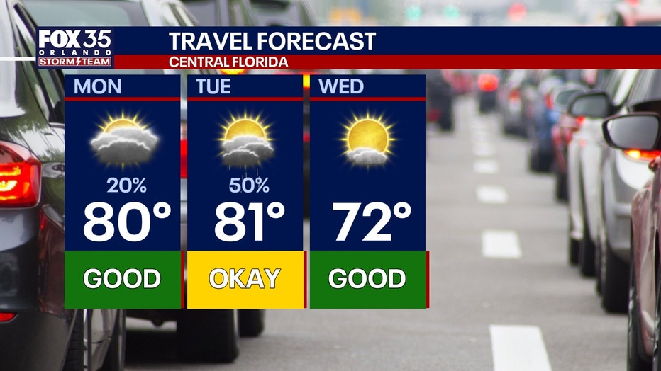
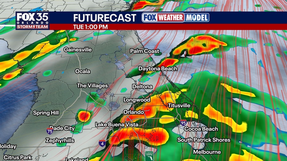
MONDAY: The warming trend continues into early this week as another system develops to our west. Highs on Monday look to top out in the upper 70s and lower 80s under peeks of sun. Rain chances rise a touch as well as the onshore flow holds. Chances are low, near 20% to kick-off the workweek. It’ll be mainly dry and mild Monday night with lows well above normal. Readings only look to dip into the middle to upper 60s.LOOKING AHEAD: As this system works eastbound on Tuesday, it’ll bring a cold front slides our way. This is when we’ll see the highest rain chances developing, rising to 50%. Hit or miss showers and a few storms are on the table as this front works through Central Florida. On the backside of it, we’ll clear out midweek as drier air settles in. Temperatures drop back below normal, into the lower to middle 70s with lowers in the 40s-50s. The chill doesn’t stick around though, with highs rising back close to 80° by the end of the workweek. Another system approaches Central Florida Friday with maybe a sprinkle or two possible. Higher rain chances unfold to begin next weekend as this cold front starts to slides our way. A few showers are on the table with highs topping out in the lower 80s.
LOOKING AHEAD: As this system works eastbound on Tuesday, it’ll bring a cold front slides our way. This is when we’ll see the highest rain chances developing, rising to 50%. Hit or miss showers and a few storms are on the table as this front works through Central Florida. On the backside of it, we’ll clear out midweek as drier air settles in. Temperatures drop back below normal, into the lower to middle 70s with lowers in the 40s-50s. The chill doesn’t stick around though, with highs rising back close to 80° by the end of the workweek. Another system approaches Central Florida Friday with maybe a sprinkle or two possible. Higher rain chances unfold to begin next weekend as this cold front starts to slides our way. A few showers are on the table with highs topping out in the lower 80s.