
JACKSONVILLE, Fla. – The rest of the day will be partly cloudy and mild with temperatures in the 70s. Tonight will feature a partly cloudy sky, and it will be cool once again. Temperatures will fall into the 40s and 50s.
As we close out the month of November, Jacksonville International Airport has not picked up any rainfall, not even a trace. This means that this November will end up being the driest November on record at the airport since records have been recorded there (1930s).
Driest Novembers on record at the Jacksonville International Airport.
We will be ahead of another system early next week, which will bring warmer temperatures to our area and the potential for a few showers. Temperatures will soar back into the 70s through Tuesday with lows in the 50s.
Showers are possible early next week.
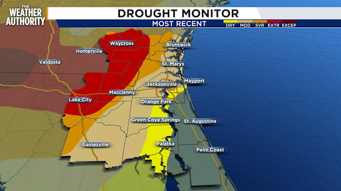
The system will move across the area on Tuesday, which will bring a chance for scattered showers to the area. Any rain would be beneficial as most of our area is in a drought.
This front will usher in cooler air on Wednesday with highs back in the 60s under plenty of sunshine.
Temperatures will eventually warm to near 70 degrees on Thursday and Friday which is around where we should be for this time of year.
THIS AFTERNOON: Mostly Cloudy & Breezy. Temperatures Near 70.
TONIGHT: Mostly Clear. Low 58.
MONDAY: Partly to Mostly Cloudy & Breezy. Isolated Rain. High 76, Low 60.
TUESDAY: Mostly Cloudy & Breezy. Scattered Rain. High 76, Low 49.
WEDNESDAY: Sun & Clouds. Cooler. High 69, Low 47.
THURSDAY: Partly Cloudy. High 70, Low 48.
FRIDAY: Partly to Mostly Cloudy. Mainly Dry. High 76, Low 50.
Copyright 2025 by WJXT News4JAX – All rights reserved.