
 2025 Atlantic hurricane season recap
The 2025 Atlantic hurricane season ended Sunday, Nov. 30 – marking the first time in nearly a decade that no major hurricanes made landfall in the U.S.
The 2025 Atlantic hurricane season ended Sunday, Nov. 30 – marking the first time in nearly a decade that no major hurricanes made landfall in the U.S.
However, Hurricane Melissa devastated Jamaica, Cuba, and the Bahamas as a record-setting, powerful storm. Here’s a look back at the 2025 season, what happened, the historical markers and records set, and a look ahead to the 2026 hurricane season.
 How many tropical storms or hurricanes formed this year?
By the numbers:
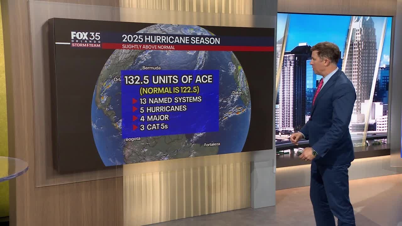
There were 13 named tropical storms, five hurricanes, and four major hurricanes during the 2025 hurricane season – near average for what was predicted.
An average hurricane season typically sees 14 named storms, seven hurricanes, and three major hurricanes.
 2025 hurricane season predictions
By the numbers:
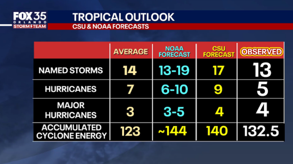
Colorado State University: 17 named storms, nine hurricanes, and four major hurricanes
NOAA: 13-19 named storms, 6-10 hurricanes, and 3-5 major hurricanes.
Hurricane predictions: Accurate or bust?
Forecasting the 2025 Atlantic hurricane season was a tricky balancing act, and NOAA’s outlook reflected that challenge. Their preseason forecast called for near normal overall activity, and in terms of total storm numbers, that is exactly where the season landed. They’d forecast 13-19 storms and we got 13, on the money. But the real story was the concentration of power.
The basin produced three Category 5 hurricanes, an unusual feat even in hyperactive years. NOAA had emphasized that warm Atlantic waters and developing La Nina conditions could drive explosive intensification, and that part of the forecast played out almost perfectly.
When judging accuracy, the headline “storm count” matters far less than the total energy expended.
ACE (accumulated cyclone energy), which tallies the strength and duration of storms rather than just their existence, landed solidly above average. NOAA’s forecast at 95-180% of ACE (or around 144 ACE) was not a miss. We had 132.5 ACE, which is higher than the normal 123 ACE.
NOAA’s outlook correctly anticipated the potential for a high end season even if the raw storm total ended below the 30-year average. The lack of United States landfalls was luck and steering, not proof of a quiet year.
Colorado State University’s preseason forecast leaned slightly higher than NOAA in storm numbers at 17 named storms, suggesting an active season ahead. On paper the basin did not deliver that storm count, but 5 less, at 13 named storms. But again, ACE is the true yardstick for whether a season was busy, and CSU’s ACE projection of 140 ACE was close to what actually happened at 132.5 ACE, correctly predicting there would be far more activity than normal.
The season’s major hurricanes were long-lived and extremely intense, which pushed total energy well into the active range. That is why ACE outperforms storm tally as an early metric.
Why didn’t hurricanes hit Florida this year? 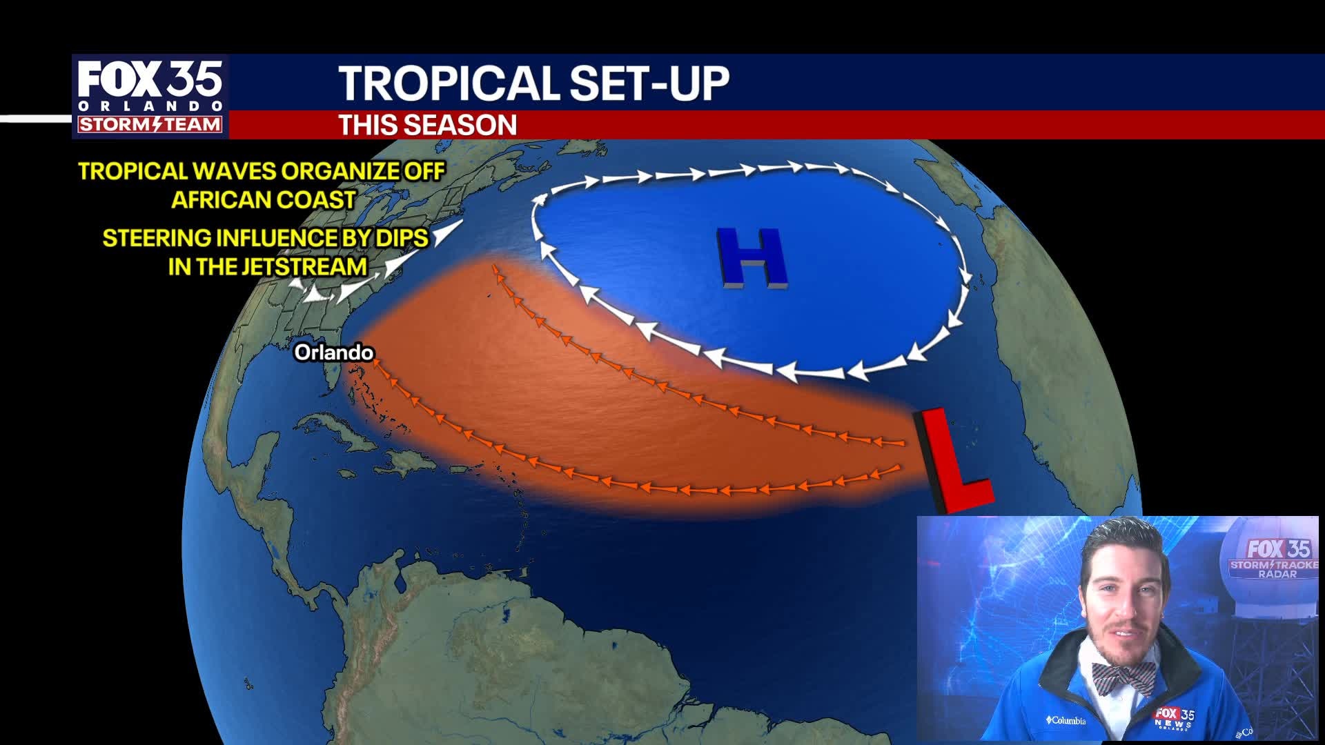
This season, no tropical storms or hurricanes had a direct hit on Florida. In fact, no tropical storms or hurricanes directly threatened the state. Hurricane Imelda came within several hundred miles of Florida’s eastern coast and brought some heavy surf and rough beach conditions for a couple of days, the only storm to have any significant impacts.
So, what happened?
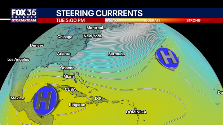
A stronger jet stream above Florida – and a weak Bermuda High (we’ll explain)
There’s been a persistent trough – or dip – in the jet stream over the eastern U.S. This has helped steer storms away from Florida rather than straight toward it.
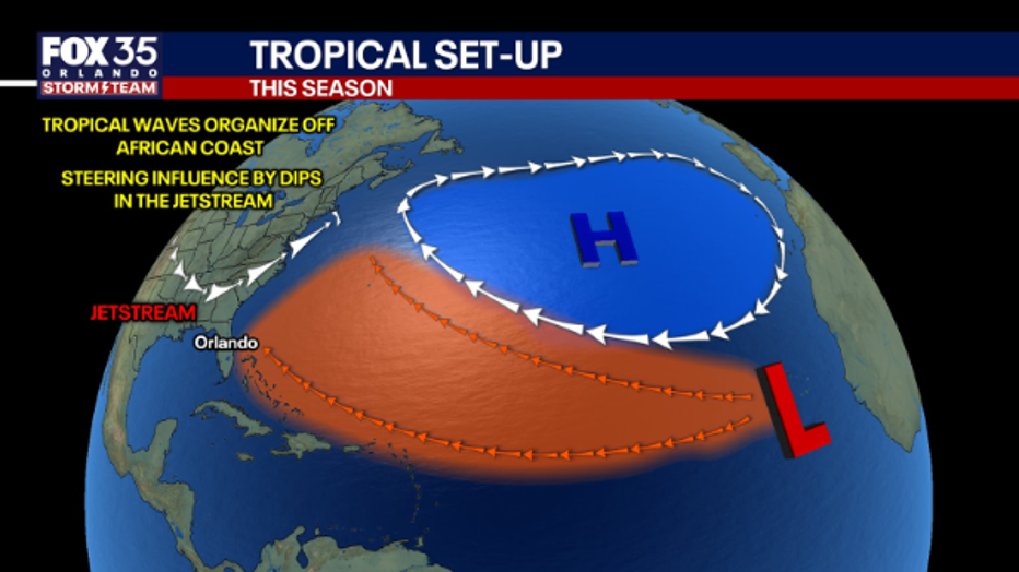
The Bermuda High – a high-pressure area in the Atlantic that often influences hurricane tracks – has been weaker and located more to the east than usual, which has allowed storms to curve north before reaching the U.S. This is why we had a large number of storms stay out in the ocean.
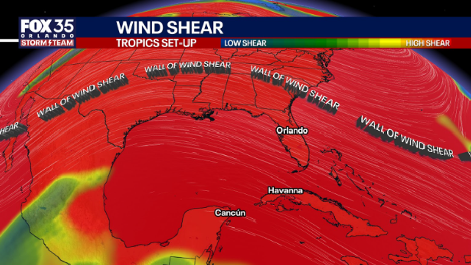
Atmospheric Conditions
Wind shear– the differences in wind speed/direction higher in the atmosphere – has been more disruptive, making it harder for storms to maintain paths toward the U.S. coast.
There are different wind strengths measured in the atmosphere – think 10,000 feet, 15,000 feet, 20,000 feet high – and the pressure at each level – measured in millibars.
There’s also been some dry air in parts of the Atlantic, which suppresses storm development or intensification.
 Some plain old luck
It’s important to note, it only takes one powerful tropical storm or hurricane to seriously impact or destroy someone’s life or community. Hurricane Melissa was late in the season and seriously damaged Jamaica, Cuba, and the Bahamas.
But, for Florida and the U.S., sometimes it also comes down to “luck.”
Meteorologists note that part of the reason is just “luck.” Even in active seasons, it’s possible for many storms to simply miss land or curve out to sea.
The timing of cold fronts pushing down from the north has also helped steer or weaken potential land-falling storms.
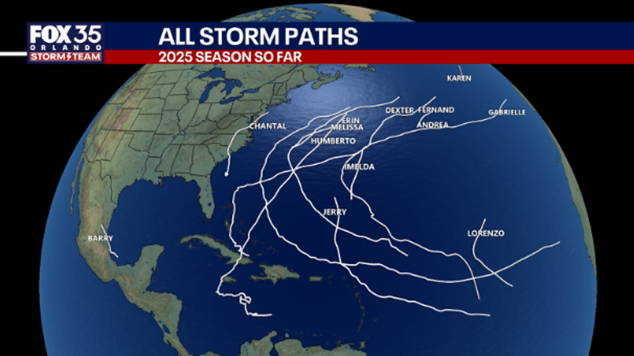
2025 Atlantic season recap: Andrea, Erin, Imelda, Melissa
The 2025 hurricane season made history as the first season on record where the initial three hurricanes all attained major hurricane status, classified as Category 3 or higher. This season overall, 4 of the 5 hurricanes were classified as Cat 3 or above at peak strength.
Tropical Storm Andrea 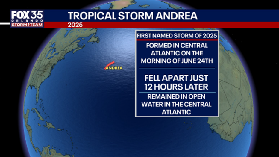
Tropical Storm Andrea was the first named storm of the 2025 Atlantic hurricane season. Andrea formed in the central Atlantic on the morning of Tuesday June 24th, 2025. Just 12 hours later that same day, Andrea quickly fell apart and became a post-tropical remnant system.
Invest 90L became well-organized on the morning of Tuesday June 24th reaching sustained winds of 40 mph and became the first tropical storm of the season. The right conditions came together enough for the storm to meet the criteria of a tropical storm before windshear ripped the storm apart.
Andrea remained over open water of the central Atlantic Ocean.
Hurricane Erin
Hurricane Erin was a long-lived, and powerful that crossed the Atlantic Ocean in August 2025. Erin became the first hurricane, first major hurricane and the first Category 5 storm of the 2025 season.
Erin started as a tropical wave on August 11th after it made its way off the west coast of Africa. Erin became a named storm as it reached tropical storm strength in the central Atlantic.
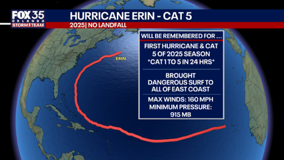
The most notable part of Erin’s path was the explosive intensification.
Erin tapped into highly favorable conditions and went from a Category 1 storm to a Category 5 storm in about 24 hours from August 15th to August 16th. At its peak at Category 5 intensity, Erin reached sustained winds of 160 mph. Erin Passed in between Bermuda and the East Coast bringing rough surf from Florida to New England from August 19th to the 21st.
Erin fluctuated in intensity as the system faced increasing windshear and eventually dissipated on August 28th.
Hurricane Imelda
Hurricane Imelda made a close pass to Florida at the end of September with tropical storm watches and high surf advisories issued along the coastline.
On September 21st, a tropical wave began near the Windward Islands produced disorganized showers and thunderstorms.
On September 27th, the wave started to gain momentum as it moved westward and became Tropical Depression Nine. As the storm tapped into the warm water of the Caribbean, the system strengthened into Tropical Storm Imelda and started to steer northward.
At this time, models had this as a very close pass to Florida’s east coast and direct landfall into the Carolinas. This fired off Tropical Storm Watches all along Florida’s East Coast. However, Imelda’s track was significantly influenced by the circulation of Category 5 Humberto about 850 miles off to Imelda’s northwest. This ultimately steered Imelda away from the East Coast of the United States.
On September 30th, Imelda reached Category 1 strength and followed up Florida’s east coast creating very high waves and rough surf. As Imelda was pulled away from the U.S. by Humberto, Imelda continued to intensify a Category 2 hurricane on October 1st.
Just after Imelda reached peak Category 2 strength, the eye of Imelda brushed the Bermuda coast with sustained winds of 100 mph.
From there, Imelda encountered windshear and dissipated by October 2nd.
Hurricane Melissa 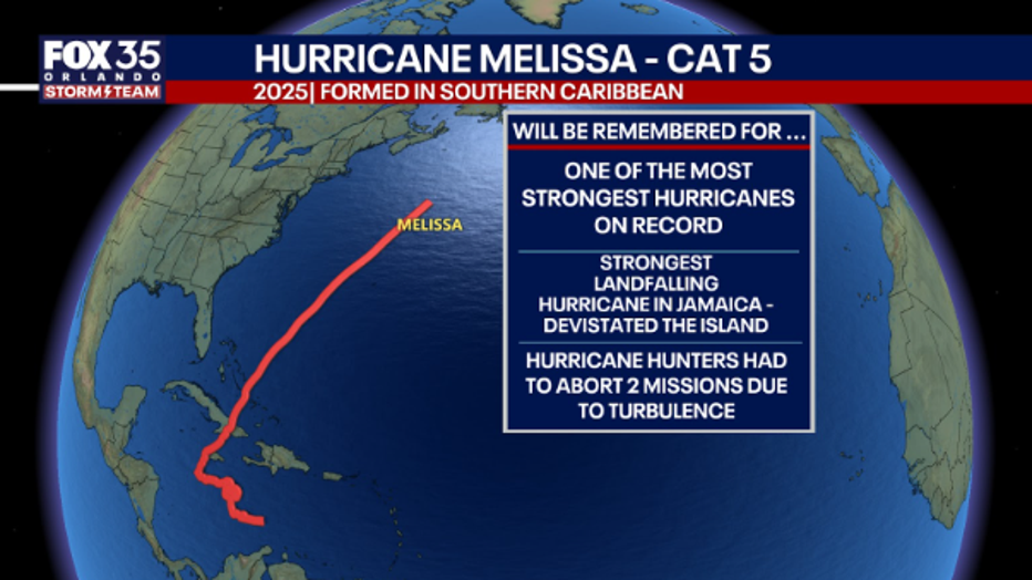
Hurricane Melissa was an extremely powerful, and catastrophic hurricane that became one of the most powerful hurricanes on record.
Melissa first formed as a topical wave that was first monitored for development on October 16. The wave originated from West Africa and drifted across the central Atlantic. This wave made it to the Windward Islands and started to organize as the wave moved westward into the Caribbean Sea.
From October 25 to 27, rapidly intensified from a tropical wave into a Category 5 hurricane. Melissa taped into an area of low windshear and the extremely warm water in the southern Caribbean. The storm once it made its way into the Caribbean sea moved very slowly. This further allowed this storm to intensify into a monster hurricane in about 48 hours.
Melissa made landfall on October 28th as a Category 5 Near New Hope, Jamaica at 1 p.m. EDT. Estimated maximum sustained winds of 185mph, 892mb minimum central pressure. It soon weakened from a Category 5 storm to a Category 3 as it made its way over the island. Melissa ripped roofs off of homes and resorts, downed power lines and trees, left most of the island without electricity and water, and left some airports on the island inoperable.
On October 29th, Melissa made landfall in Cuba at about 3 a.m. EDT as a very destructive Category 3 hurricane with sustained winds of 120 mph.
Later on October 29th, Melissa passed through the Bahamas as a Category 1 storm.
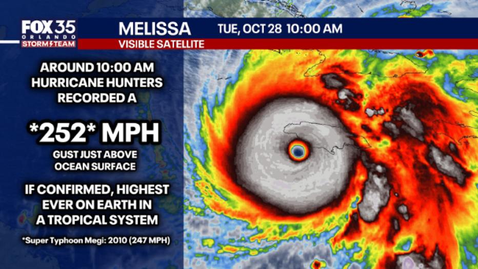
Melissa forced Hurricane Hunters to turn back – twice
During the ferocity of Hurricane Melissa, both the NOAA and Air Force Hurricane Hunters conducted flight missions to collect crucial data. Two missions were forced to abort the mission due to extreme turbulence creating unsafe environments to the crew and the aircraft.
The storm’s wind speeds and immense power made for dangerous missions at the storm’s peak. One flight even encountered trapped birds inside the eyewall.
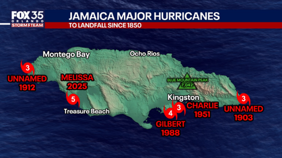
Will the name Melissa be retired?
Category 5 Melissa was not only the most intense Jamaica landfall on record, but tied for the most intense landfall on record anywhere in the Atlantic Basin. Because of this and the destruction that Melissa caused in Jamaica and Cuba, the name Melissa will likely be retired.
Ultimately, it will be up to the WMO to decide whether to retire the name. That usually happens several weeks after the season ends.
Storm names are decided by the WMO and rotate every six years. When a name is retired – usually when a storm is significantly destructive or deadly, like Hurricane Ian – a new name is added to the list.
2025 hurricane season historical markers and records
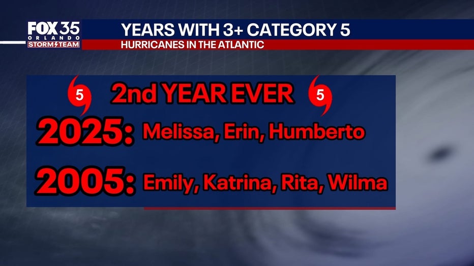
Most perplexing about this hurricane season is that it is just the second time in recorded history with 3+ Category 5 hurricanes.
Category 5 hurricanes are uncommon in their own rate. There has been a documented increase in Category 5 storms (sustained wind speeds 157+ MPH) in recent years.
Example: from 1924 to 2000, there were around 28 Category 5 hurricanes in the Atlantic. In the years since, there have been 17, which represents nearly a 65% increase. This is largely attributable to warmer ocean surface temperatures, but also slightly a role from increased observations from hurricane hunters and satellite data to better quantify storms. Meaning, there may be a small number of storms historically pre satellites and hurricane hunters that could have been rated Category 5 had there been better detection methods.
There have been 45 Category 5 hurricanes on record since 1850.
This equates to one Category 5 storm about every 2 to 2.5 years mathematically.
2025: Humberto, Erin, Melissa
2005: Emily, Katrina, Rita, Wilma
Rapid intensification of storms increasing in the Atlantic basin
Rapid intensification continues to be a growing trend in the tropical Atlantic.
Rapid intensification is defined as a storm that increases its sustained winds by more than 35 MPH in a 24-hour period, or deepening its atmospheric pressure by 42+ millibars in the same timeframe.
In the last 20 or so years, the occurrence of rapid intensification has more than doubled the long term, historical average. Likely attributable again to the warming ocean surface temperatures, which are the main driver of tropical activity.
It should be noted that climate change and global warming have conflicting impacts on tropical weather. Research suggests that a warming planet will have a net positive impact on more storms undergoing rapid intensification, because of hotter water in the ocean. But, either a steady number of storms occurring each year, or even a drop over time.
This is because the entire atmosphere warms as well – and to get a hurricane to form in the first place, you need instability in the atmosphere, which means colder air aloft. If that higher level air warms too much, hurricanes may struggle to form, but the ones that do, could become extreme intensity (like we have seen in recent years).
More milestones of 2025 hurricane season
First season with no land-falling hurricanes in the U.S. since 2015
Melissa was the latest into the year for a hurricane to form in the Caribbean since 1997.
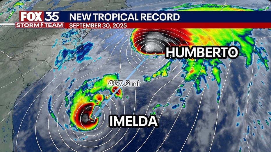
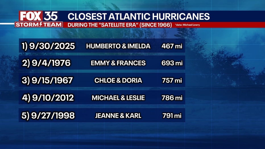
Imelda and Humberto became the closest two hurricanes ever got to each other in the Atlantic Ocean basin, since the “satellite era” began (1960s).
The first storm of the year, Andrea, was the latest start to the Atlantic season since 2014.
Karen became the northernmost tropical system in the Atlantic on record with a latitude further north than Boston, Massachusetts for perspective
Hurricane Melissa was the strongest and most intense Atlantic hurricane to make landfall on record with 185 MPH winds and a pressure at landfall of 892 mb (other storms have gotten stronger that did not make landfall at that level)
2025 will go down as the first season with multiple Category 5 hurricanes (2+) since 1932 and 1933.
 2026 hurricane season: What to expect
It seems odd to look ahead to the upcoming hurricane season, but the data gathered during the previous season can help anticipate and prepare for the next one. Remember, it only takes one tropical storm or hurricane to significantly damage a community and change people’s lives.
2026 Atlantic hurricane season dates
The 2026 Atlantic Hurricane Season will begin on June 1, 2026, and will run through November 30, 2026. While it is rare to see a tropical storm or hurricane form outside of those dates, it is not impossible.
2026 Atlantic hurricane season predictions
Colorado State University will likely issue its prediction for the 2026 hurricane season in the spring, typically early June. NOAA will then issue its hurricane prediction close to the start of the season.
Here are the 2026 Atlantic hurricane storm names:
Arthur
Bertha
Cristobal
Dolly
Edouard
Fay
Gonzalo
Hanna
Isaias
Josephine
Kyle
Leah
Marco
Nana
Omar
Paulette
Rene
Sally
Teddy
Vicky
Wilfred
Prepare early
It is never too early to prepare for the upcoming hurricane season. — as it is only six months away. Here are some tips to keep in mind:
– Prepare an emergency kit and review your family’s emergency plan
– Know whether you live in an evacuation zone or not and, if so, what your evacuation route is.
– Review insurance policies and documents to make sure you have the coverage needed.
– Do a review of the outside and inside of your home and make repairs to protect it. Make sure to check for overgrown trees, bushes, and other plants in and around the yard.
The Source: This 2025 Atlantic hurricane season recap was put together by the FOX 35 Storm Team: meteorologists Brooks Garner, Noah Bergren, Jessica Dobson, Laurel Blanchard, and T.J. Springer. Information pulled from National Hurricane Center, NOAA, hurricane hunters, and Colorado State University.