
Race Day Showers | Timing Out a Soggy Weekend In Central Florida
Race Day Showers | Timing Out a Soggy Weekend In Central Florida
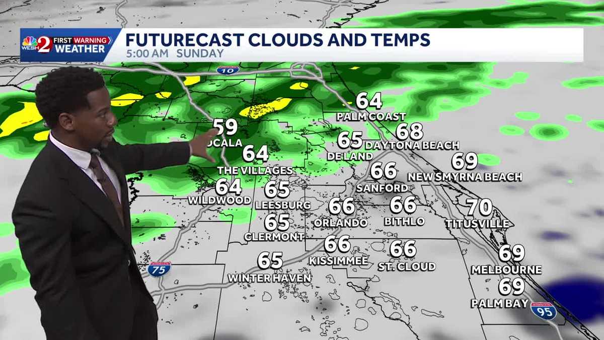
METEOROLOGIST MARQUISE MEDA MARQUISE. THE WEEKEND IS NEAR. THE BIG RACES ARE HAPPENING THIS WEEKEND AND PEOPLE JUST WANT TO GET OUTSIDE FOR THE GOOD DECEMBER SHOPPING SEASON. WELL, UNFORTUNATELY, IF YOU GET OUTSIDE OVER THE COURSE OF THE WEEKEND, YOU’LL HAVE TO BRING YOUR UMBRELLA WITH YOU. WE HAVE RAIN SHOWERS MOVING IN, BUT YOU MENTIONED THE RACE DAY, RIGHT? YOU RAN THE RACE BEFORE. WHAT TYPE OF TEMPERATURE SHOULD RUNNERS LIKE? COOLER. YEAH, THE BEST RACES I’VE EVER RUN. AS FAR AS, LIKE, DISTANCE ARE BETWEEN, YOU KNOW, LITERALLY 35 AND 45 DEGREES. YEAH. WE’RE NOT GOING TO HAVE ANY OF THAT HERE IN CENTRAL FLORIDA. UNFORTUNATELY, WARMER WEATHER WILL BE COMING YOUR WAY TO START OFF THE WEEKEND, AND YOU’LL STILL BE ABOVE YOUR SEASONAL AVERAGE ON SUNDAY AS YOU FINISH IT OFF WITH HIGHS IN THE UPPER 70S. NOW. SUNDAY IS DEFINITELY THE WETTER OF THE TWO WEEKEND DAYS, AS WE’LL SEE A 60% COVERAGE OF SHOWERS COMING YOUR WAY TO FINISH OFF THE WEEKEND COMING UP, AND THAT RAIN, UNFORTUNATELY, COULD INCLUDE A COUPLE STRONGER STORMS. FOR THE MOMENT, THOUGH, WE’RE STILL TRENDING DRY HERE IN CENTRAL FLORIDA AND WARMER THAN EVERYWHERE ELSE ACROSS THE COUNTRY. NO SURPRISE THERE. WINTER IS UPON THE MAJORITY OF THE STATES ACROSS THE US THAT SAY 49 OUT OF THE 50. THE EXCEPTION THAT BEING THE SUNSHINE STATE. AND WE SAW WHAT A LOT OF SUNSHINE WARMING TEMPERATURES UP TODAY. BUT OVER THE COURSE OF THE NEXT FEW DAYS, RAIN WILL BEGIN TO WORK ITS WAY IN COURTESY OF THIS SYSTEM OF LOW PRESSURE MOVING OUT OF THE GULF, IT WILL SWING INTO THE ATLANTIC BY THE TIME SUNDAY IS HERE, BUT WE ARE SEEING SOME SHOWERS OFF TOWARDS THE GULF COAST RIGHT NOW. AS YOU MOVE ON OUT TOWARDS CEDAR KEY, YOU WATCH A COUPLE LIGHTER ROUNDS OF RAIN HEAD YOUR DIRECTION. BUT HERE IN CENTRAL FLORIDA, JUST A FEW EXTRA CLOUDS AS THE SUN HAS NOW SET AND WE SEE TEMPERATURES OF 70 DEGREES IN DOWNTOWN ORLANDO. NEW SMYRNA, WHERE YOUR SUNSET DOES SHOW THOSE GRAYS AND PINKS. WE HAVE TEMPERATURES SHOWING 65 DEGREE CONDITIONS AS WELL. SO ULTIMATELY THE FURTHER SOUTH YOU MOVE, TEMPERATURES ARE TRENDING A LITTLE BIT WARMER RIGHT NOW AT 619 LOWER 70S FOR KISSIMMEE, SAINT CLOUD, MELBOURNE AND PALM BAY. WE ALSO HAVE OUR TREE LIGHTING CEREMONY TAKING PLACE IN SEMINOLE COUNTY THIS EVENING. PLEASANT CONDITIONS WILL BE PRESENT AS WE MOVE ACROSS THE REST OF YOUR EVENING. THOSE CLOUDS WILL BEGIN TO SEPARATE AND WILL BE CLEARING COOL BY 9:00 WITH TEMPERATURES IN THE LOWER 60S. SO HERE’S THE SEPARATION OF CLOUDS ON FUTURECAST RIGHT NOW. PARTLY CLOUDY OR MOSTLY CLOUDY SKIES WILL BE PRESENT PAST YOUR OVERNIGHT HOURS, AND THAT MEANS YOU’RE WAKING UP TO SOME GORGEOUS SUN SHINE HERE IN CENTRAL FLORIDA TO KICK OFF YOUR FRIDAY MORNING. YOUR 12 HOUR FORECAST SHAPES UP LIKE THIS. WE SEE THE CLOUDS PARTING WAYS, AND WE’LL OPEN THE DOOR FOR TEMPERATURES TO DROP INTO THE LOWER 60S. AS WE CONTINUE ACROSS YOUR OVERNIGHT HOURS. SO I’LL CALL IT COMFORTABLE WEATHER TONIGHT. WARMER CONDITIONS ARE BACK TOMORROW. LOOK TO FINISH OFF YOUR WORK WEEK WITH HIGHS RANGING BETWEEN THE 70S AND THE MIDDLE OF THE 80S UNDER MOSTLY SUNNY SKIES DURING THE AFTERNOON, WATCH OUT FOR A SOUTHERLY BREEZE. GUSTS COULD BE AS HIGH AS 20MPH ON FRIDAY. AND HERE’S A LOOK AT YOUR TEMPERATURE SPREAD COOLER AS YOU HEAD TOWARDS PALM COAST, WITH TEMPERATURES IN THE UPPER 70S THERE. NOW WE DO HAVE A SMALL CHANCE FOR A SPRINKLE OF RAIN FRIDAY IN THE EVENING ACROSS OUR NORTHERNMOST COUNTIES, AND THIS IS GOING TO BE THE AREA THAT WE’LL SEE THE MOST WIDESPREAD SHOWERS AND THE HEAVIEST RAINFALL ACCUMULATION HEADING INTO SUNDAY COMING UP. BUT JUST IN TIME FOR THE HALF MARATHON, WE COULD ADD IN A SPRINKLE OF RAIN AND TAKE A LOOK AT THESE TEMPERATURES THAT YOU’RE WAKING UP TO ON SATURDAY. UPPER 60S, LOW 70S OUT THE DOOR. MORE WIDESPREAD RAIN ACROSS THE I-4 CORRIDOR SATURDAY IN THE AFTERNOON. BUT SUNDAY IS GOING TO BE THE SUPER SOAKER OF YOUR WEEKEND DAYS, ESPECIALLY ACROSS OUR NORTHERNMOST COUNTIES. THIS ALL TAKING PLACE OVERNIGHT AND THEN INTO THE MORNING AS TEMPERATURES DROP BACK INTO THE UPPER 50S AND LOWER 60S. SO BEFORE MONDAY IS SAID AND DONE, WE COULD ACCUMULATE ANYWHERE BETWEEN 2 AND 3IN ACROSS MARION AND ALSO FLAGLER COUNTIES. HEAVIEST HITTING AREAS FOR RAIN AND AFTER THE RAIN PASSES US BY, WE’RE DRIER BY TUESDAY AND ALSO COOLER. LOOK TO SEE TEMPERATURES IN OCALA DROP DOWN INTO THE 40S ON TUESDAY. IN THE MORNING, WE’LL BE BACK IN THE LOWER 50S HERE IN ORLANDO. STILL A COUPLE CHANCES FOR RAIN ON MONDAY, BUT WE’RE SMOOTHLY SAILING WITH SUNSHINE TUESDAY THROUG
Race Day Showers | Timing Out a Soggy Weekend In Central Florida
Race Day Showers | Timing Out a Soggy Weekend In Central Florida

Updated: 7:42 PM EST Dec 4, 2025
Race Day Showers | Timing Out a Soggy Weekend In Central FloridaQuiet weather conditions will remain in place through the end of the workweek as temperatures gradually rise here in Central Florida. Highs today were back in the mid and upper seventies with sunny skies extending throughout the state. We’ll bottom out in the lower sixties tonight with partly cloudy conditions. As for tomorrow, expect to be above seasonal in the afternoon as temps will cross over into the lower eighties to wrap your workweek. There will be a very small chance for a pop-up shower otherwise expect to remain dry. This weekend though, rain chances will be increasing. Lighter showers will be in place Saturday ahead of a descending cold front. Sunday will include the worst of the rain with a 60% coverage of showers & the heaviest rain will be across most of our northern counties. This is all due to a cold front which will keep a few lingering showers over the area Monday. But the biggest chance with this front moving through will be a shift in temperatures. Expect overnight lows to fall into the forties Tuesday/Wednesday.
Race Day Showers | Timing Out a Soggy Weekend In Central Florida
Quiet weather conditions will remain in place through the end of the workweek as temperatures gradually rise here in Central Florida. Highs today were back in the mid and upper seventies with sunny skies extending throughout the state. We’ll bottom out in the lower sixties tonight with partly cloudy conditions. As for tomorrow, expect to be above seasonal in the afternoon as temps will cross over into the lower eighties to wrap your workweek. There will be a very small chance for a pop-up shower otherwise expect to remain dry. This weekend though, rain chances will be increasing. Lighter showers will be in place Saturday ahead of a descending cold front. Sunday will include the worst of the rain with a 60% coverage of showers & the heaviest rain will be across most of our northern counties. This is all due to a cold front which will keep a few lingering showers over the area Monday. But the biggest chance with this front moving through will be a shift in temperatures. Expect overnight lows to fall into the forties Tuesday/Wednesday.