
ORLANDO, Fla. – We kicked off the weekend with a slightly cooler Saturday morning that gave way to a warm afternoon. Tonight will be a repeat into your Sunday as well.
But, by Sunday night, that’s when things begin to evolve with the approach of our next cold front. This cold air doesn’t bring with it a promising shot for rain, I’m afraid, but it does promise to deliver the next dose of pre-winter season cold conditions to Central Florida.
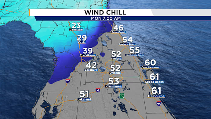
Monday morning could be on the freezing side when you look at the feel’s like temps in our northern counties. (Copyright WKMG 2025)
We could see feel’s like temperatures for our northern counties dipping back into the upper 20s once the coldest air arrives combined with how quick this air will be flowing in from up north. Alachua and Marion counties could start their Monday with feel’s like temps hovering in the mid to upper 20s.
The majority of us should be geared up for colder temps all the way around our neighborhood as we wander into another full work week, especially Monday and Tuesday. Afternoon high’s will need to fight hard if they want to touch the 70 degree mark, which looks highly unlikely for Monday especially.
Because we’re Florida though, we will give this cold snap a warm send off by Wednesday once we start to observe afternoon high’s climbing right back into the low to mid 70s. From there, it actually seems we might make our final approach towards Christmas sitting in above average conditions for a good chunk of mid-December.
Where’s the rain in all this? If you’re looking for it, I hate to be the bearer of bad news.
Below average rain chances are likely to remain in the area through Christmas (Copyright WKMG 2025)
This weekend was actually looking kind of showery early on. During our last rain event, computer models were sold we’d see another favorable set up to bring Central Florida at least a splash of necessary rain as drought conditions try to emerge once again.
Since about the Monday–Tuesday time frame however, those chances dried up.
South Florida looks to hog the action, where they could developing afternoon showers and isolated storms. For our area, things will be quiet. (Copyright WKMG 2025)
If you’ve stuck with me for a little while now, you’ve probably heard me mention that we’ve hit the time of the year where the jet stream high above us in the atmosphere dictates the weather.
While this is true year-round, we can at the very least count on the general moist, humid environment during our summer months to bring rounds of sea breeze action during the afternoon.
As we move towards the climax of fall into winter, we don’t have that safety net to keep Florida from browning over and drying out. If the jet decides it wants to stay up north, the rain will stay away as well.
When you take a look at the upper air layout of our jet stream and where our high and low pressure systems flow over the next 7-10 days, rain should remain scarce in our neck of the woods.
If you though the initiation of winter meant Florida would cave to colder temps, I’m concerned you might be disappointed. (Copyright WKMG 2025)
Down the pike, the European and American computer models are targeting an approaching future front that could slide some moisture and rainfall into Central Florida as we round out the teens of December into the final countdown towards Christmas.
Dec. 19 is what seems to be our date to watch for a rainfall resurrection for at least a number of us.
That enormous dome of orange is doing to jack up our temperatures as we get closer to the calendar start of Winter and the Christmas holiday. (Copyright WKMG 2025)
Until then, dominant and stubborn ridging is slated to build in overhead driving temperatures upward and rain chances a little further downward.
Daily Forecast
The News 6 Weather team ensures you’re always on top of the day’s weather.
Copyright 2025 by WKMG ClickOrlando – All rights reserved.