
JACKSONVILLE, Fla. — Here’s what the First Alert Weather Team said you can expect for the First Alert Weather forecast:
RIGHT NOW: We are in the upper 70s! Cloud cover is increasing as a cold front makes its way across our area. We are going to go from the upper 70s to the 30s in about a 12-hour span.TONIGHT: It is going to be WINDY with winds out of the northwest overnight. At the beaches, gusts will be around 40 mph. TOMORROW MORNING: Hard freezes (<27°F) for inland SE Georgia. Feels like temperatures will be in the upper teens Monday morning.Light freezes (=32°F) are expected for inland northeast Florida. Feels like temperatures will be in the 20s on Monday morning. 34° is our forecasted low for Jacksonville. Onshore winds keep the beaches in the 40s. But, when you factor in the wind, it’ll feel much colder.We will start to warm up on Tuesday. The warming trend sticks around through the week.Christmas week will feature warmer-than-average temperatures across the majority of the US. 12-hour
WATCH THE FORECAST | DOWNLOAD THE APPS
Follow Action News Jax Meteorologists on Twitter for updates:
Mike Buresh | Garrett Bedenbaugh | Corey Simma | Trevor Gibbs
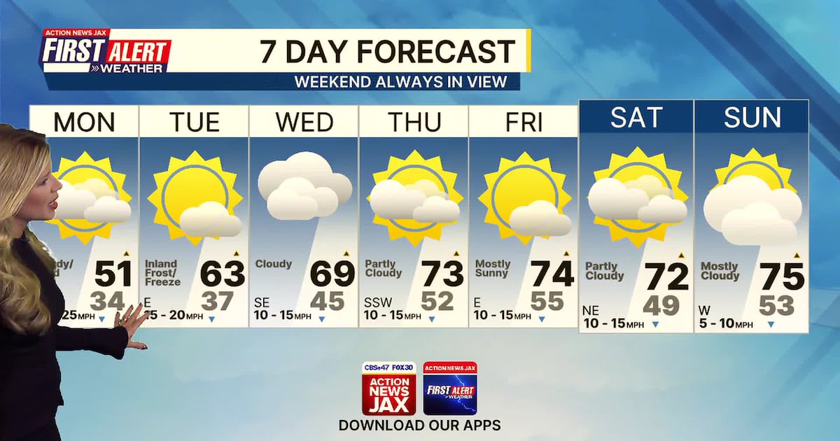
First Alert 7-day Forecast:TONIGHT: Windy and cold. LOW: 34 (20s in SE GA).TOMORROW: Breezy and cold. Feeling like the 40s throughout the day. HIGH: 51TUE: Inland frost/freeze. Mostly sunny and starting to warm up. 37/63WED: Mostly cloudy. 45/69THU: Partly cloudy. 52/73FRI: Mostly sunny and warm. 55/74SAT: Partly cloudy. 49/72SUN: Mostly cloudy and mild. 53/75
LISTEN: Mike Buresh ‘All the Weather, All the Time’ Podcast
INTERACTIVE RADAR: Keep track of the rain as it moves through your neighborhood