
Freeze Warnings and Frost Advisories in Place For Northern Florida | Frigid and Breezy Workweek Start
Freeze Warnings and Frost Advisories in Place For Northern Florida | Frigid and Breezy Workweek Start
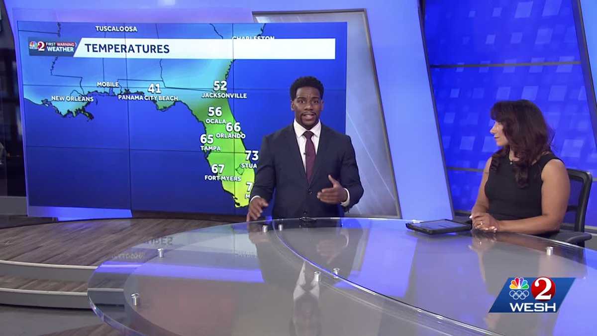
MEDIA. WE’RE GOING TO GET AN UPDATE RIGHT NOW WITH OUR FIRST WARNING, METEOROLOGIST MARK MARQUISE MEDA MARQUISE. WE KNOW THOSE COOLER TEMPERATURES ARE COMING WITH THAT COLD FRONT, BUT SOME AREAS ARE REALLY GOING TO FEEL IT HARDER THAN OTHERS. ABSOLUTELY. AS WE TAKE A LOOK AT THE STATE BEHIND ME RIGHT NOW. RIGHT. IT’S A TALE OF TWO COMPLETELY DIFFERENT FORECASTS. PANAMA CITY BEACH, YOU’RE DOWN IN THE LOWER 40S. IT FEELS LIKE WINTER ACROSS THE PANHANDLE, BUT IT ACTUALLY FEELS LIKE SUMMER. IF YOU’RE IN MIAMI ACROSS SOUTH BEACH, 73 DEGREES, THESE ARE YOUR CURRENT TEMPERATURES. SO QUITE THE DISPARITY AS YOU TRAVEL FROM NORTH TO SOUTH, RIGHT. WE’RE SMACK DAB IN THE MIDDLE OF THAT HERE IN ORLANDO, STILL SITTING COMFORTABLY FOR THE MOMENT, BUT THE COOLER WEATHER WILL BE UPON US AS THE NIGHT DOES PROGRESS. IN FACT, THE FURTHER NORTH YOU GO, THERE ARE FREEZE WARNINGS IN PLACE FROM ALACHUA COUNTY ALL THE WAY TO THE FLORIDA GEORGIA STATE LINE. NOT FOR US HERE IN CENTRAL FLORIDA, BUT ONCE YOU FACTOR IN THE WIND CHILL, THAT’S A BIG STORY FOR TONIGHT. THOSE STRONG AND GUSTY WINDS, WE’LL SEE THOSE TEMPERATURES FEEL LIKE THEY’RE IN THE 30S ACROSS SOME OF OUR COUNTIES HERE IN CENTRAL FLORIDA, ALSO ALONG THE COAST WITH A WIND ADVISORY IN PLACE. WE DO HAVE ALSO A HIGH SURF ADVISORY AS BREAKING WAVES COULD BE ANYWHERE BETWEEN 7 AND 10FT OUT THE DOOR. TOMORROW. TAKE A LOOK AT THE COASTLINE. OUR TOWER CAM IS A LITTLE BIT SHAKY HERE ACROSS NEW SMYRNA BEACH, TEMPERATURES SHOW 63 DEGREES, BUT NOTICE YOUR WINDS ARE COMING IN FROM THE NORTH AND THOSE ARE YOUR SUSTAINED SPEEDS OF 21MPH. AS WE TAKE A LOOK AT THE WAVE HEIGHTS ALL THE WAY THROUGH TUESDAY, WE COULD BE DEALING WITH 4 TO 8 FOOT CONDITIONS. SO UNFORTUNATELY, NOT THE BEST BEACH AND BOATING WEATHER. AND YOU SEE THOSE STRONG, GUSTY WINDS ACROSS NEW SMYRNA BEACH NEARLY ALL NIGHT LONG, IN WHICH THOSE GUSTS CAN EXCEED 35MPH AT TIMES. SO HERE’S A LOOK AT THE FUTURECAST, IN WHICH WE’RE NOT SHOWING ANY STRONG CHANCES FOR RAIN. WE ARE SHOWING STRONG AND BREEZY WEATHER HERE. GUSTY CONDITIONS ALL ACROSS THE COAST ABOVE 25MPH INLAND. THEY’RE STILL QUITE FAST. LOOK AT OCALA. WHAT WE’RE GOING TO DO IS STOP THIS RIGHT AROUND 8:00. THESE ARE THE WINDS THAT YOU’LL BE DEALING WITH FROM THE NORTH AND THE WEST, RIGHT AROUND 25 MILE PER HOUR CONDITIONS. SO WITH THAT IN MIND, TEMPERATURE READINGS ON YOUR THERMOMETER WILL BE IN THE LOWER 40S. ONCE YOU MOVE INLAND ACROSS I-75. BUT WHEN YOU FACTOR THE TWO TOGETHER, THE WINDY CONDITIONS AND THE COOLER WEATHER, HERE’S WHAT IT’S GOING TO FEEL LIKE AS EARLY AS 8:00. IT’S GOING TO FEEL LIKE 34 DEGREES. THAT’S THE POWER OF THE WIND CHILL RIGHT THERE. EVEN IN WILDWOOD, IT’S GOING TO FEEL LIKE YOU’RE IN THE UPPER 30S AS WELL. SO ALTHOUGH WE DON’T HAVE ANY ADVISORIES OUT, IT’S STILL GOING TO BE A COOL AND BLUSTERY START TO YOUR WORK WEEK. AS WE CONTINUE ON WITH FUTURECAST, THOUGH, EVENTUALLY WE’LL START TO DEFROST HERE IN CENTRAL FLORIDA, HIGH PRESSURE IS GOING TO SWING OUT TOWARDS THE EAST AND WILL WELCOME IN MILD CONDITIONS WITH HIGHS IN THE MID 70S AS WE CONTINUE ACROSS THE WORKWEEK. WEDNESDAY. BUT MONDAY, UNFORTUNATELY, WE’RE NOT MAKING IT OUT OF THE 60S. IT’S A COOL WORKWEEK START EVERYWHERE YOU LOOK HERE IN CENTRAL FLORIDA, AS YOU’LL BE WELL BELOW YOUR SEASONAL AVERAGE ON MONDAY BY ABOUT TEN DEGREES. BUT EVENTUALLY WE’RE IN THE MID 70S, WEDNESDAY, UPPER 70S, THURSDAY AND FRIDAY, AND WE’RE COUNTING DOWN TO THE HOLIDAY SEASON EIGHT DAYS OR SEVEN DAYS AWAY FROM THE START OF THE WINTER SOLSTICE. BUT AS WE MOVE INTO CHRISTMAS, NOT ONLY ARE WE TRENDING WARM, WE’RE ALSO TRENDING DRY HERE IN CENTRAL FLORIDA, NOT MANY STRONG RAIN CHANCES OVER THE NEXT WEEK, BUT EVENTUALLY WARMER TEMPERATURES WILL BE HERE. LOOK TO START OFF YOUR WEDNESDAY IN THE MID 50S AND THEN EVENTUALLY WE’LL
Freeze Warnings and Frost Advisories in Place For Northern Florida | Frigid and Breezy Workweek Start
Freeze Warnings and Frost Advisories in Place For Northern Florida | Frigid and Breezy Workweek Start

Updated: 11:36 PM EST Dec 14, 2025
Freeze Warnings and Frost Advisories in Place For Northern Florida | Frigid and Breezy Workweek StartWe hope you were able to enjoy the heat this weekend. Highs today found their way into the upper seventies both inland and along the coast. Tonight, a dry cold front will be pushing across the region, bringing strong gusty winds and cooler temperatures into the picture to start the workweek. Winds tonight will be between 15-25mph, with occasional gusts of 40 along the coast. For this reason, a Wind Advisory will be in place for coastal Flagler, Volusia, and Brevard Counties. We’ll start to see winds pick up at 7:00pm tonight and the advisory will be in place through 9AM tomorrow. Although this front will have very little rain chances, the bigger take away will be the temperature swing. Monday morning highs will plummet to the low/mid-sixties, with overnight lows (Monday into Tuesday) falling to the forties and fifties.
Freeze Warnings and Frost Advisories in Place For Northern Florida | Frigid and Breezy Workweek Start
We hope you were able to enjoy the heat this weekend. Highs today found their way into the upper seventies both inland and along the coast. Tonight, a dry cold front will be pushing across the region, bringing strong gusty winds and cooler temperatures into the picture to start the workweek. Winds tonight will be between 15-25mph, with occasional gusts of 40 along the coast. For this reason, a Wind Advisory will be in place for coastal Flagler, Volusia, and Brevard Counties. We’ll start to see winds pick up at 7:00pm tonight and the advisory will be in place through 9AM tomorrow. Although this front will have very little rain chances, the bigger take away will be the temperature swing. Monday morning highs will plummet to the low/mid-sixties, with overnight lows (Monday into Tuesday) falling to the forties and fifties.