
Front moving through Central Florida; slight cooldown this weekend
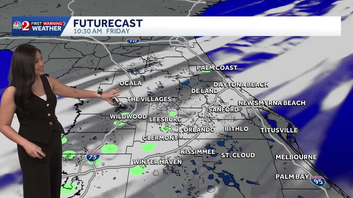
OPERATIONAL. AT 518, WE GOT TO BRING IN FIRST WARNING METEOROLOGIST CAM TRAN BECAUSE JUST A REMINDER, IT’S FRIDAY. I KNOW, SO LOOKING FORWARD TO. OKAY, CAM A LITTLE DANCE. LOOKING FORWARD TO THE WEEKEND. YEAH GUYS. HOLIDAY SHOPPING. ARE YOU ALL DONE? MOSTLY THERE’S ALWAYS THERE’S ALWAYS SOMETHING LAST MINUTE THAT I MIGHT ORDER. WELL, THAT’S GOING TO BE US TODAY. YEAH, MAYBE THAT’S WHY I’M, LIKE, GETTING A PEP IN MY STEP BECAUSE I’M LIKE, OH MY GOSH, AT LEAST THE WEATHER IS NICE FOR YOU. LAST MINUTE SHOPPERS MYSELF INCLUDED. YES, BECAUSE WE HAVE A COLD FRONT TO MOVE THROUGH TODAY THAT COULD BRING A STRAY SPRINKLE THIS MORNING AND SOME CLOUDS. BUT BEHIND THAT FRONT, A GORGEOUS STRETCH OF WEATHER. SO LET’S GO AHEAD AND TAKE A LOOK. THAT COLD FRONT IS STILL WELL OFF TO OUR NORTH. AND THAT’S WHY WE’RE SEEING THAT UPTICK IN CLOUD COVER THIS MORNING. AS WE TAKE A LOOK AT OUR SATELLITE AND RADAR. QUITE A BIT OF CLOUD COVER OUT AND ABOUT. WE ARE SEEING SOME BREAKS THERE IN NORTHERN MARION COUNTY. BUT OVERALL LOTS OF CLOUDS AROUND AND CAN’T RULE OUT A STRAY SPRINKLE THIS MORNING AS WELL. IN FACT, THAT’S WHAT WE’RE SEEING RIGHT NOW IN FAR RURAL OSCEOLA COUNTY. HERE WE DO HAVE A TINY SHOWER THAT’S WELL EAST OF NARCOOSSEE THIS MORNING ON NOVA ROAD. OTHERWISE, RADAR IS PRETTY QUIET THIS MORNING. BUT ONCE AGAIN TO LATE MORNING. HERE’S A LOOK AROUND TEN 11:00. AGAIN, A STRAY SPRINKLE CAN’T BE RULED OUT. THAT’S WHY I HAVE A 10% CHANCE OF RAIN IN THE FORECAST TODAY. ONCE THAT FRONTAL SYSTEM CLEARS US THOUGH, WE ARE GOING TO SEE DRIER CONDITIONS THIS AFTERNOON AND MORE SUNSHINE AS WELL BECAUSE BEHIND THAT FRONT, WE’RE GOING TO START TO SEE SOME DRIER AIR WORKING ITS WAY IN. AND THAT’S GOING TO CLEAR OUT THOSE CLOUDS. SO BY 2 TO 3:00 THIS AFTERNOON, EXPECT MOSTLY SUNNY SKIES. LIVE LOOK OUTSIDE THIS MORNING. THIS IS A LIVE LOOK AT TAVARES. LOOK HOW CALM AND QUIET IT IS. AND IT’S ALSO VERY WARM. THE TEMPERATURES THAT WE’RE SEEING THIS MORNING ARE CLOSE TO WHERE OUR HIGHS SHOULD BE FOR THIS TIME OF YEAR, SO YOU WON’T NEED THOSE JACKETS RIGHT NOW AT 71 IN DELAND, 71 IN THE CITY. BEAUTIFUL. 72 IN MELBOURNE AND 71 IN SAINT CLOUD. LATER TODAY, TEMPERATURES WILL TOP OUT RIGHT AROUND THE UPPER 70S TO RIGHT AROUND THE LOW 80S BEFORE THAT FRONT ARRIVES. SO IT’S GOING TO BE A WARM DAY AND ALSO RATHER BREEZY AS WELL. WITH THE WIND OUT OF THE SOUTHWEST AT 5 TO 15MPH, GUSTING UP TO 20 AT TIMES, SO BREAKING OUR 12 HOUR FORECAST. LOTS OF CLOUDS TO START OFF THE DAY. WE’LL TOP OUT RIGHT AROUND 71 JUST AFTER LUNCHTIME. ONCE THAT FRONT CLEARS US, WE’LL START TO SEE THOSE SKIES CLEAR OUT. AND MORE SUNSHINE THIS AFTERNOON. AND BEHIND THAT FRONT WE WILL SEE A BIT OF A COOLDOWN. NOT A SIGNIFICANT ONE, BUT OVERNIGHT LOWS WILL DROP DOWN INTO THE LOW 50S. 53 IN ORLANDO AREAS NORTH AND WEST OF ORLANDO WILL BE IN THE 40S. WE’LL START OFF ON SUNDAY IN THE UPPER 50S, AND WE ARE LOOKING AT A NICE DAY AHEAD FOR MONDAY MORNING. SO WE START TO SEE THOSE TEMPERATURES MODERATE A BIT AS WE GO INTO EARLY NEXT WEEK. THIS UPCOMING WEEKEND. LOOKING FABULOUS, A HIGH OF 77 ON SATURDAY, 79 THE HIGH ON SUNDAY AND LOOKING AHEAD FOR YOUR CHRISTMAS HOLIDAY WEEK. WE COULDN’T ASK FOR A NICER FORECAST. HIGH PRESSURE IS GOING TO BE IN CONTROL. PERFECT WEATHER WITH HIGH PRESSURE IN CONTROL. THAT MEANS SUNSHINE AND DRY CONDITIONS AND TEMPERATURES WILL BE PRETTY MILD. WE’RE TALKING ABOUT CHRISTMAS EVE STARTING OFF IN THE UPPER 50S HIGHS IN THE UPPER 70S. AND THAT WILL BE THE CASE FOR CHRISTMAS DAY AS WELL. HERE’S A LOOK AT YOUR CENTRAL FLORIDA CERTIFIED MOST ACCURATE SEVEN DAY FORECAST. A WINTER OFFICIALLY BEGINS ON SUNDAY, BUT IT REALLY WON’T FEEL LIKE IT. AND THEN LOOK AT THAT. A NICE STRETCH OF WEATHER THROUGH CHRISTMAS DAY. AND HERE’S A LOOK AT YOUR SEVEN DAY. FOR FOLKS ALONG THE COAST, YOU WILL SEE A NICE STRETCH OF SUNSHINE, BUT WE WILL SEE AN UPTICK I
Front moving through Central Florida; slight cooldown this weekend

Updated: 5:57 AM EST Dec 19, 2025
Central Florida experiences a mild start with temperatures in the upper 60s to low 70s and mostly cloudy skies, as a cold front moves through the area today. A stray shower is possible this morning, but the front is expected to clear by the afternoon, bringing more sunshine later today. Behind this front, a slight cooldown is anticipated for the weekend, with lows in the 50s and warm afternoon highs. Christmas week looks perfect with sunny skies, cool nights, and warm afternoons.First Warning Weather Stay with WESH 2 online and on-air for the most accurate Central Florida weather forecast.RadarSevere Weather AlertsDownload the WESH 2 News app to get the most up-to-date weather alerts. The First Warning Weather team includes First Warning Chief Meteorologist Tony Mainolfi, Eric Burris, Marquise Meda and Cam Tran.
Central Florida experiences a mild start with temperatures in the upper 60s to low 70s and mostly cloudy skies, as a cold front moves through the area today.
A stray shower is possible this morning, but the front is expected to clear by the afternoon, bringing more sunshine later today.
Behind this front, a slight cooldown is anticipated for the weekend, with lows in the 50s and warm afternoon highs.
Christmas week looks perfect with sunny skies, cool nights, and warm afternoons.
First Warning Weather
Stay with WESH 2 online and on-air for the most accurate Central Florida weather forecast.
Download the WESH 2 News app to get the most up-to-date weather alerts.
The First Warning Weather team includes First Warning Chief Meteorologist Tony Mainolfi, Eric Burris, Marquise Meda and Cam Tran.