
Winter warmth for Christmas week in Southwest Florida
Expect cool mornings and warm afternoons across the Gulf Coast.
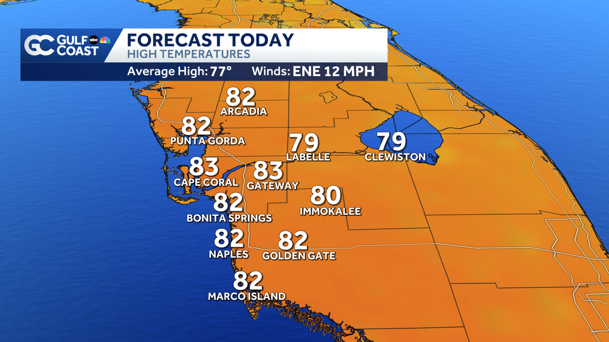
CHRISTMAS. GOOD STOCKING STUFFER EGGS OUT OF >> WE’RE IN THE WEATHER JACKPOT HERE. I MEAN IT COMING OFF A BEAUTIFUL WEEKEND. 85 YESTERDAY. TEMPERATURES ELECTION TREND A LITTLE LOWER. >> AS WE LOOK AHEAD CHRISTMAS MORNING, YEAH, IT PROBABLY WILL STICK AROUND FLORIDA QUITE SOMETIME. WE SAW HIM SWIMMING DOWN AROUND THE KEYS JUST A MOMENT AGO. BUT CHRISTMAS MORNING WILL BE A LITTLE BIT COOLER UPPER 50’S TO LOWER 60’S. AND LOOKING AHEAD TO THURSDAY AFTERNOON, LOWER 80’S TEMPERATURES A BIT ABOVE AVERAGE. BUT I DON’T THINK TOO MANY PEOPLE BE COMPLAINING BECAUSE HUMIDITY WILL ALSO BE RELATIVELY LOW AS IT’S GOING TO FEEL QUITE REFRESHING AND WE ARE FAR FROM OUR WARMEST CHRISTMAS ON RECORD BACK IN 2016, WE ALMOST MADE IT UP TO 90 THAT YEAR. 88 DEGREES. OUR COLDEST CHRISTMAS HIGH TEMPERATURE BACK IN 2022. JUST A FEW YEARS AGO ONLY MADE IT INTO THE UPPER 40’S. AND AS WE LOOK LIVE NOW FROM BABCOCK RANCH AND FOUNDER’S SQUARE. BEAUTIFUL, FESTIVE CHRISTMAS SCENE THERE. AND HERE’S A LOOK AT YOUR FORECAST FOR YOUR MONDAY. STARTING OFF IN THE LOWER 60’S RIGHT NOW WE’RE UP TO 67 WITH SUNSHINE BY 09:00AM BEAUTIFUL. SUNNY SKIES HERE AS WE TAKE YOU THROUGH THE AFTERNOON AND BOUNCING BACK INTO THE 80’S ONCE AGAIN TODAY. NOT QUITE AS WARM AS YESTERDAY. HERE’S ONE OF THE REASONS SAYS THE WINDS PICK UP FROM THE EAST-NORTHEAST. THESE ARE THE WIND GUSTS STARTING AROUND 11:00AM AND INTO THE AFTERNOON, UP TO AROUND 20 TO 25 MILES PER HOUR. SO A LITTLE ON THE BREEZY SIDE MIGHT WANT TO MAKE SURE YOUR INFLATABLES ARE SECURE IF THEY DON’T END UP THE NEIGHBOR’S YARD, AT LEAST MERRY CHRISTMAS, RIGHT? 81 DEGREES NORTH FORT MYERS, 81 IN FORT MYERS TODAY. WE’RE TRACKING LOWER 80’S FOR MOST OF THE GULF COAST’S 79 GORDA. SO KIND OF RIGHT THERE ON THE CUSP OF 80 AND WE’LL SEE 80’S LOWER 80’S FOR THE MOST PART. THEY’RE FROM NAPLES, NAPLES PARK AND ORANGE TREE. AND WITH THAT WIND COMING OFF, THE LAKE TODAY ARE INLAND NEIGHBORHOODS. MOORE HAVEN, CLEWISTON WILL LIKELY TOP OUT JUST SHY OF 80 TONIGHT. MOSTLY CLEAR. A LITTLE COOL. BUT WE’VE SEEN SOME CHILLIER NIGHTS DEFINITELY SLIGHTLY LESS HUMID, TOO. WITH THAT EAST, NORTHEASTERLY WINDS SUSTAINED CLOSE TO 10 MILES PER HOUR. AND WE’RE GOING TO SEE SOME SLIGHTLY DRIER AIR MOVE INTO THE GULF COAST STARTING TOMORROW AND WEDNESDAY. SO A LITTLE LESS HUMID THAT WILL SET THE STAGE FOR A BEAUTIFUL WEEK OF WEATHER. AND EVEN THOUGH IT’S GOING TO BE WARM IN THE AFTERNOONS ARE MORNINGS. STILL A LITTLE BIT CHILLY SIDE DOWN IN THE UPPER 50’S WEDNESDAY, CHRISTMAS EVE MORNING AND THEN CHRISTMAS MORNING DOWN TO 59. WE STAY IN THE UPPER 50’S ALL THE WAY THROUGH THE WEEKEND. HERE’S YOUR GULF COAST. 7 DAY FORECAST. WHAT THING THAT WOULD BE REALLY NICE TO HELP OUT WITH OUR RAINFALL DEFICIT AND DROUGHT IS RAIN, OF COURSE. BUT AS WE LOOK OVER THE NEXT 7 DAYS, WE DON’T HAVE REALLY ANY RAIN CHANCES. NOTHING ABOVE 10%. SO THROUGH THE WEEKEND, THE BEAUTIFUL WEATHER CONTINUES. HIGHS IN THE LOWER 80
Winter warmth for Christmas week in Southwest Florida
Expect cool mornings and warm afternoons across the Gulf Coast.

Updated: 6:52 AM EST Dec 22, 2025
We’re in store for another beautiful, sunny and warm day across Southwest Florida as daytime highs bounce back into the lower 80s. Winds will pick up out of the east northeast today, gusting up to 20 to 25 mph. High pressure will continue to dominate our weather pattern through the Christmas holiday. Each day will feature morning temperatures near 60 degrees, and upper 50s for inland locations, along with mostly sunny skies. Highs will peak in the lower 80s.This weather pattern should hold for at least another week. Some early indications appear that a pattern shift may come early next week with the arrival of our next cold front and even some rain. Live Interactive RadarCheck out the interactive Gulf Coast Live RadarWatch your Gulf Coast Weather forecasts on TV or onlineHere’s where to find our latest weather forecast videoYou can also watch newscasts live or on demand hereOr download the Gulf Coast News app to stream on your phone or tabletYour Gulf Coast Storm TeamChief Meteorologist Allyson RaeMeteorologist Caroline CastoraMeteorologist Jim DickeyMeteorologist Jason DunningMeteorologist Lauren HopeMeteorologist Raphael TavernierMeteorologist Rob DunsMeteorologist Sara BlueDOWNLOAD the free Gulf Coast News app for your latest breaking news and weather alerts. And check out the Very Local Gulf Coast app to stream news, entertainment and original programming on your TV.
FORT MYERS, Fla. —
We’re in store for another beautiful, sunny and warm day across Southwest Florida as daytime highs bounce back into the lower 80s.
Winds will pick up out of the east northeast today, gusting up to 20 to 25 mph.
High pressure will continue to dominate our weather pattern through the Christmas holiday. Each day will feature morning temperatures near 60 degrees, and upper 50s for inland locations, along with mostly sunny skies. Highs will peak in the lower 80s.
This weather pattern should hold for at least another week. Some early indications appear that a pattern shift may come early next week with the arrival of our next cold front and even some rain.
Live Interactive Radar
Watch your Gulf Coast Weather forecasts on TV or online
Your Gulf Coast Storm Team
DOWNLOAD the free Gulf Coast News app for your latest breaking news and weather alerts. And check out the Very Local Gulf Coast app to stream news, entertainment and original programming on your TV.