
Another dry, clear night for Southwest Florida Monday
Rain chances remain very low for the Gulf Coast through the rest of the work week.
WELL, THE BIG WEATHER STORY HERE ON THE GULF COAST AS THAT STABLE AND NICE WEATHER IS BACK IN CHARGE OF OUR 7 DAY FORECAST. >> IT ALSO MEANS AROUND THE SUN. PRETTY COMFORTABLE TEMPERATURES AT NIGHT MOST ESPECIALLY OVER THE NEXT 3 NIGHTS WHEN NIGHTTIME LOWS ACROSS THE BOARD SHOULD BE ABLE TO DROP BACK INTO THE 60’S. YOU CAN SEE THIS PLAY OUT OVER THE NEXT 12 HOURS WITH LOTS OF SUNSHINE THROUGH 6 7 O’CLOCK TONIGHT. THE ONLY EXCEPTION WOULD BE LIKE WE TALKED ABOUT DURING THE LAST WEATHER CAST, A LITTLE BIT OF HAZE OVER FORT MYERS AND CAPE CORAL FROM SOME CONTROLLED BURNS EARLIER THIS AFTERNOON. BUT AGAIN, OVER THE NEXT FEW HOURS, THE AIR QUALITY WILL CONTINUE TO IMPROVE. AS I MENTIONED BEFORE, THOUGH, NIGHTTIME, LOW TEMPERATURES IN NICELY DROPPING OFF INTO THE 60’S TONIGHT. 66, FOR INSTANCE, IS THE NIGHTTIME LOW TEMPERATURE FORECAST IN FORT MYERS, IN NEIGHBORING CAPE CORAL, DOWN TO 67 TONIGHT IN ESTERO AND BONITA, UPPER 60’S AND MORE COMMON ACROSS PORTIONS OF SOUTHWEST COLLIER COUNTY MID TO UPPER 60’S ARE ON THE LITTLE WESTERN SIDE OF LAKE OKEECHOBEE. AND THEN, OF COURSE, SIMILAR NUMBERS EXPECTED IN CHARLOTTE AND DESOTO. 64 65 TONIGHT FOR AREAS LIKE PORT CHARLOTTE AND GORDA. THOSE MORNING NIGHTTIME LOW TEMPERATURES WILL SET THE TABLE FOR A REALLY NICE DAY TOMORROW. WE’LL SEE LOTS OF SUNSHINE. AND AS LONG AS THERE’S NO CONTROLLED BURNS AROUND ANOTHER DAY OF ON FILTERED SUNSHINE IS IT LOOKS LIKE CLOUD COVER WILL BE FEW AND FAR BETWEEN TOMORROW. ONE OF THE REASONS WHY IS BECAUSE OUR RAIN CHANCES FOR JUST SO LOW, NOT EVEN ONE TIME A DAY AS RAIN, CHANCES BETTER THAN 10% TOMORROW. SO FIND SOMETHING FUN TO DO AFTER WORK AND GET OUTDOORS AND ENJOY IT OVER THE NEXT 2 OR 3 DAYS. REALLY ONLY ONE DAY AS THE EVEN THE SHOT FOR ANY KIND OF RAIN. AND THAT MOVES OUR DIRECTION ON THURSDAY. BUT I DO WANT TO STRESS THAT ISOLATED IS THE WAY TO FREEZE ANY RAIN COVERAGE ON WEDNESDAY. FOR INSTANCE, THIS IS WHAT FUTURE CAST IS DEPICTING FOR WEDNESDAY AFTERNOON AND WEDNESDAY EVENING GIVES US A LITTLE MORE CLOUD COVER THAN WHAT WE SAW TODAY. BUT, YOU KNOW, THERE YOU GO ONE OR 2 WHILE THE ISOLATED SHOWERS AND RIGHT NOW THAT SHOULD ABOUT RAMP THINGS UP FOR US ON WEDNESDAY ACROSS LEE COUNTY, YOU ARE EXPAND THIS TO THE REGIONAL VIEW ON WEDNESDAY. IT’S A IT’S A PRETTY SIMILAR STORY ANYWHERE YOU MAY HAPPEN TO CALL HOME LITTLE MORE CLOUD COVER IS COMPARED TO TODAY AND PERHAPS ONE OR 2 ISOLATED SHOWERS. BUT THE RAIN OPPORTUNITIES ARE NOT LOOKING TOO PROMISING FOR US ON WEDNESDAY. AND THAT REALLY IS THE DAY ON THE SEVEN-DAY FORECAST RIGHT NOW DURING THE WORKWEEK THAT HAS EVEN THE SHOT OR THE OPPORTUNITY FOR ANY KIND OF RAIN MOVING OUR IN THE SEVEN-DAY FORECAST TO SOMETHING ELSE. YOU’LL NOTICE WHEN IT COMES TO THE NIGHT TIME LOWS IS THAT OVERNIGHT TONIGHT INTO EARLY TOMORROW MORNING. THAT WILL BE THE COOLEST OF THE NIGHT TIME LOWS, AT LEAST FOR A WHILE. THERE WILL BE A VERY SLOW AND GRADUAL WARMING TREND WHEN IT COMES TO THE NIGHTTIME LOWS AND THEY WILL AGAIN END UP IN THE 70’S. ONCE WE FINISH UP THE WORKWEEK AND THEN APPROACH THE START OF THE UPCOMING THE WEEKEND INTO EARLY NEXT WEEK. BUT AGAIN, SOMETHING ELSE TO POINT OUT HERE IS THAT RAIN OPPORTUNITIES ARE TRENDING VERY, VERY LOW FOR US. NOT EVEN ONE DAY RIGHT NOW HAS RAIN OPPORTUNITIES GREATER THAN 30%. AND THAT ALSO MEANS OF THE TROPICS ARE LOOKING AWFULLY QUIET FOR US. AS I MENTIONED TO YOU EARLIER TODAY, TROPICAL STORM LORENZO FORM THIS THIS EARLIER TODAY, BUT AGAIN POSES ABSOLUTELY NO THREAT WHATSOEVER TO ANY PARTS OF NORTH AMERICA. AND AT LEAST RIGHT NOW, THERE’S NO THERE ARE OTHER SYSTEMS ON THE HORIZON FOR SO WE’LL KEEP OUR FINGERS CROSSED THAT WE’LL JUST GET TO ENJOY THE NICE WEATHER AS WE FINISH UP THE HURRICANE SEASON, WHICH AS YOU
Another dry, clear night for Southwest Florida Monday
Rain chances remain very low for the Gulf Coast through the rest of the work week.

Updated: 4:59 PM EDT Oct 13, 2025
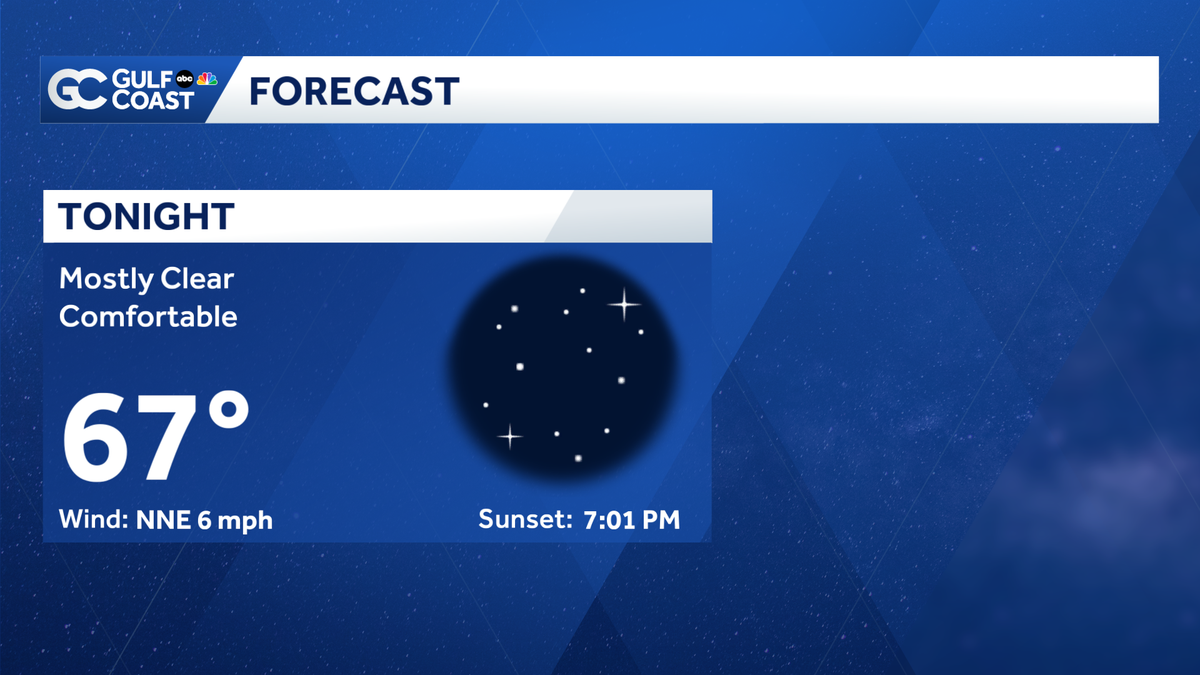
Our beautiful, dry weather continues heading into Monday evening for the Gulf Coast. Lows will fall into the upper 60s again with mostly clear skies. Expect another dry, sunny day on Tuesday with highs reaching the seasonal upper 80s. High pressure will dominate the weather pattern over the next several days, keeping our weather mostly dry and our humidity relatively low.Rain chances will remain near or below 10% this week without any big weathermakers coming our way over the next week.As we transition into the dry season this week, many coastal communities are experiencing a rainfall deficit. While the entire region is still drought-free, we’ll be monitoring any drought development in the coming weeks as rain opportunities become more infrequent.The Atlantic hurricane season runs from June 1 through Nov. 30. Follow Gulf Coast News online and on air for Southwest Florida’s Most Accurate weather forecast.Be prepared with the Gulf Coast News 2025 Hurricane GuideLive Interactive RadarCheck out the interactive Gulf Coast Live RadarWatch your Gulf Coast Weather forecasts on TV or onlineHere’s where to find our latest weather forecast videoYou can also watch newscasts live or on demand hereOr download the Gulf Coast News app to stream on your phone or tabletYour Gulf Coast Storm TeamChief Meteorologist Allyson RaeMeteorologist Caroline CastoraMeteorologist Jim DickeyMeteorologist Jason DunningMeteorologist Lauren HopeMeteorologist Raphael TavernierMeteorologist Rob DunsMeteorologist Sara BlueDOWNLOAD the free Gulf Coast News app for your latest breaking news and weather alerts. And check out the Very Local Gulf Coast app to stream news, entertainment and original programming on your TV.
FORT MYERS, Fla. —
Our beautiful, dry weather continues heading into Monday evening for the Gulf Coast. Lows will fall into the upper 60s again with mostly clear skies.
Expect another dry, sunny day on Tuesday with highs reaching the seasonal upper 80s.
High pressure will dominate the weather pattern over the next several days, keeping our weather mostly dry and our humidity relatively low.
Rain chances will remain near or below 10% this week without any big weathermakers coming our way over the next week.
As we transition into the dry season this week, many coastal communities are experiencing a rainfall deficit. While the entire region is still drought-free, we’ll be monitoring any drought development in the coming weeks as rain opportunities become more infrequent.
The Atlantic hurricane season runs from June 1 through Nov. 30. Follow Gulf Coast News online and on air for Southwest Florida’s Most Accurate weather forecast.
Live Interactive Radar
Watch your Gulf Coast Weather forecasts on TV or online
Your Gulf Coast Storm Team
DOWNLOAD the free Gulf Coast News app for your latest breaking news and weather alerts. And check out the Very Local Gulf Coast app to stream news, entertainment and original programming on your TV.