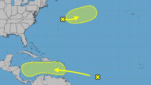
The National Hurricane Center on Friday continued to track a pair of systems with a chance to develop into the season’s next tropical depression or storm.
As of the NHC’s 8 p.m. tropical outlook, the biggest threat to land was a tropical wave about 1,000 miles east of the Caribbean’s Windward Islands in the central tropical Atlantic with a large area of showers and thunderstorms.
“Gradual development of this system is possible over the next several days while it moves generally westward at 15 to 20 mph,” forecasters said. “Regardless of development, this system is expected to bring heavy rainfall and gusty winds to the Windward Islands late this weekend and then move across the Caribbean Sea much of next week.”
The NHC gave it a near 0% chance to develop in the next two days and 30% chance to develop in the next seven.
8 am EDT – A tropical wave is located over the central tropical Atlantic. Gradual development of this
system is possible over the next several days while it moves generally westward at 15 to 20 mph. Regardless of development, this system is expected to bring heavy rainfall and… pic.twitter.com/d5JxYNv8I3
— National Hurricane Center (@NHC_Atlantic) October 17, 2025
The second system was a nontropical area of low pressure well off the coast of the northeastern United States.
“There is a slight chance that the system could develop some subtropical characteristics during the weekend before it turns northeastward over cooler waters by early next week,” forecasters said.
The NHC gave it a 10% chance to develop in the next two to seven days.
If either were to develop into a named storm, they could become Tropical or Subtropical Storm Melissa.
Of the 12 named storms this year, four have grown into hurricanes, and three of those became major hurricanes. Only one, Tropical Storm Chantal, made a U.S. landfall this year.
Hurricane season runs from June 1-Nov. 30.
Originally Published: October 17, 2025 at 8:00 AM EDT

