
Brace Yourself! Frosty Weather Funnels Into Central Florida on New Year’s Eve | Wind Chill in the 30s
Brace Yourself! Frosty Weather Funnels Into Central Florida on New Year’s Eve | Wind Chill in the 30s
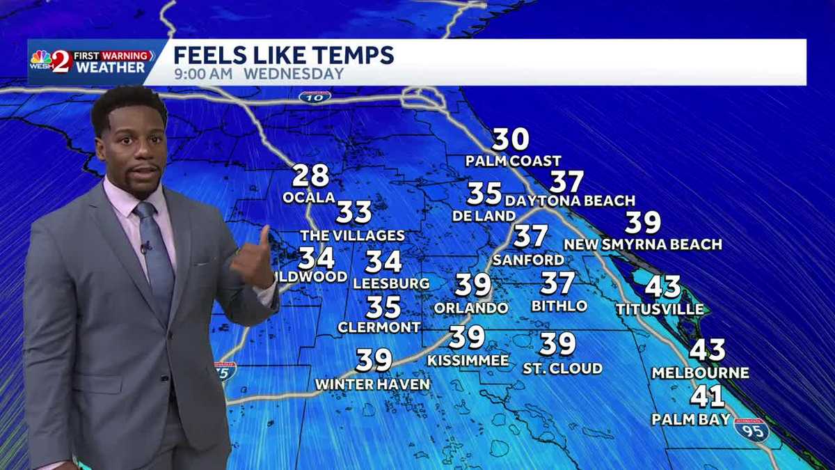
RIGHT. FOR NOW. FOR NOW, THAT’S WHAT I’M SAYING. ENJOY IT. BECAUSE I DON’T THINK IT’S GOING TO BE THERE VERY LONG. I GOT YOU, YOU GOT TO ENJOY THE WARM WEATHER WHILE IT’S STILL HERE IN CENTRAL FLORIDA, BECAUSE THAT WON’T BE HERE MUCH LONGER EITHER. WE’LL SEE WHAT COMES BACK, THOUGH. YEAH, EVENTUALLY IT’S GOING TO TAKE US SOME TIME. BUT AS YOU HEAD OUTSIDE ON NEW YEAR’S EVE, YOU’LL NEED TO BUNDLE UP BECAUSE YOU’LL SEE TEMPERATURES LIKE THIS WAITING OUTDOORS FOR YOU. NOW, ON THE 31ST, YOU’LL WAKE UP TO TEMPERATURES IN THE LOWER 40S. A SIGNIFICANT DROP OFF FROM WHERE WE PREVIOUSLY WERE. WE’RE BACK IN THE 50S ON MOST DAYS, UPPER 50S AND LOWER 60S, BUT WE’LL FALL DOWN TO 40 DEGREES ON THE DOT ON THE 31ST JANUARY FIRST, AS WE SAY HELLO TO 2026, WE’LL BE STARTING OFF THE DAY WITH 43 DEGREES, OVERNIGHT LOWS. AND WE’LL CARRY THOSE COOLER TEMPERATURES INTO NEXT FRIDAY AS WELL. TAKE A LOOK AT YOUR AFTERNOON HIGHS IN ORLANDO. THOSE ARE BACK IN THE MID 60S. BUT HERE’S A BROAD LOOK AT TEMPERATURES ALL ACROSS CENTRAL FLORIDA ON NEW YEAR’S EVE ITSELF. YOU’LL BE DOWN IN THE LOW 30S IN OCALA, MID 30S FOR THE VILLAGES WAY UP NORTH IN PALM COAST, 37 DEGREES. ONCE YOU CROSS OVER EAST OF I-4, THAT’S WHEN YOU MOVE INTO THE 40S, BUT YOU’RE STILL WELL BELOW YOUR SEASONAL AVERAGE. NOT THE COLDEST THAT WE’VE BEEN SO FAR THIS YEAR. THAT WAS BACK IN NOVEMBER. ON THE 11TH, WE DROPPED DOWN TO 36 DEGREES OVERNIGHT. LOWS IN ORLANDO WILL COME PRETTY CLOSE ON NEW YEAR’S EVE, WITH A WAKEUP TEMPERATURE OF 40 OUT TOWARDS CAMPING WORLD STADIUM. RIGHT NOW, THOUGH, TEMPERATURES SHOW 78 DEGREES. WE ALL PEAKED IN THE UPPER 70S AND LOWER 80S TODAY IN ORLANDO. WE HAVEN’T COOLED SO MUCH FROM OUR HIGHS THIS AFTERNOON, AND ALSO JUST A COUPLE STREETS OVER AT THE KIA CENTER. WE’LL BE WATCHING THE ORLANDO MAGIC HOST THE CHARLOTTE HORNETS IN WHICH AT 5:00 COMING UP, TEMPERATURES IN THE UPPER 70S AND STILL GREAT WEATHER BY THE TIME WE TIP OFF AT 7:00, 72 DEGREES THERE. OUR FORECAST SO FAR THIS WEEK HAS BEEN DICTATED BY THIS SYSTEM OF HIGH PRESSURE. WE’RE WATCHING THAT SAG TOWARDS THE SOUTH, WELL OFF TO THE EAST. IT’S A WEAK FRONTAL BOUNDARY, NOT REALLY IMPACTING OUR FORECAST. WE’LL HAVE A COUPLE OFFSHORE SHOWERS TONIGHT, BUT ULTIMATELY, AS WE STILL REMAIN UNDER THIS SYSTEM OF HIGH PRESSURE, CALMER WINDS WILL BE BACK TONIGHT. BUT LOOK AT THE WIND DIRECTION THAT WE’RE PULLING IN FROM OUR WEST COAST. WE SEE THAT WESTERLY BREEZE MOVING OVER THE BIG BEND AREA FROM THE EAST COAST. IT’S AN ATLANTIC BREEZE, SO BOTH AREAS PICKING UP THE MOISTURE FROM BOTH SIDES OF CENTRAL FLORIDA, WHICH IS WHY WE WILL BE TRENDING FOGGY UNDERNEATH. HIGH PRESSURE. AND THOSE SEA BREEZES TONIGHT, THE WESTERLY BREEZE WILL BE A LITTLE BIT MORE PROMINENT, IN WHICH IF YOU’RE ANYWHERE WEST OF I-4, THERE’S A CHANCE THAT YOU MAY BE STEPPING OUTDOORS TO A DENSE FOG ADVISORY TOMORROW, AS YOUR VISIBILITY RESTRICTIONS WILL FALL BELOW A STATUTE MILE, THAT FOG WILL LIFT AS WE HEAD INTO THE WEEKEND, COMING UP WITH HIGH TEMPERATURES IN THE UPPER 70S. BUT AS WE KICK OFF THE WORKWEEK. A COLD FRONT COMES BARRELING IN AND WE SAY GOODBYE TO THOSE WARMER DAYS. COLDER WEATHER LIES AHEAD OF US AS WE SAY HELLO TO JANUARY 1ST RINGING IN THE NEW YEAR WITH A CHILLY TREND AS FAR AS RAINFALL IS CONCERNED, WE WON’T SEE TOO MUCH OF THAT, RIGHT? ANYWHERE BETWEEN MAYBE A QUARTER OF AN INCH OR HALF OF AN INCH AT BEST. AS YOU HEAD TOWARDS OUR NORTH AND WESTERNMOST AREAS. OCALA, THE VILLAGES. BUSHNELL, WE’RE LOOKING AT YOU GUYS ALONG I-75. THE EUROPEAN MODEL IS PICKING UP ON THE RAIN. THE GFS MODELS PICKING UP ON THOSE COOLER TEMPERATURES. NO RAIN THOUGH. AS FAR AS THE FROST CONCERN. LOOK AT THIS ON WEDNESDAY. OUT THE DOOR IN THE MORNING ALL ACROSS CENTRAL FLORIDA. THOSE FEELS LIKE TEMPERATURES WILL BE PLUMMETING ALL THE WAY DOWN INTO THE 30S. BUT WE COULD HAVE EVEN FREEZING CONCERNS ACROSS I-75. ONCE YOU MAKE YOUR WAY NORTH INTO MARION COUNTY, IN WHICH THOSE TEMPERATURES WILL DROP BELOW THE FREEZING LEVEL, AND WE’RE NEARLY JUST AS COOL AS WE KICK OFF THE DAY ON THURSDAY. COMING UP. SO CHILLY CONDITIONS DO LIE AHEAD OF US. YOUR THURSDAY MORNING TEMPERATURES ARE BACK IN THE 30S AND THE 40S BEFORE WE GET THERE, THOUGH. LOWER 80S IN THE AFTERNOON THIS WEEKEND. ON SUNDAY, WE’LL SEE SIMILAR NUMBERS ON MONDAY, BUT THAT TREND OF COOLER WEATHER ARRIVES ON TUESDAY AND WILL STICK AROUND TO THE END O
Brace Yourself! Frosty Weather Funnels Into Central Florida on New Year’s Eve | Wind Chill in the 30s
Brace Yourself! Frosty Weather Funnels Into Central Florida on New Year’s Eve | Wind Chill in the 30s

Updated: 6:43 PM EST Dec 26, 2025
Brace Yourself! Frosty Weather Funnels Into Central Florida this New Year’s EveDry, mostly sunny conditions will continue across Central Florida through the weekend as high pressure remains in control. Highs will run above normal in the upper 70s to low 80s, with midmornings in the 50s. Light winds and clear skies will allow for nightly fog development, with visibility possibly dropping to 1 mile or less the clearing shortly after sunrise. Along the coast, a moderate to high rip current risk is expected each day, with a higher risk possible over the weekend. A strong cold front moves through late Monday night into Tuesday with little rainfall inland, but better rain chances along the coast. Behind the front, much colder and drier air settles in. Temperatures will drop sharply, with highs only in the 50s and 60s and overnight lows falling into the 30s and low 40s by midweek. Wind chills may dip into the upper 20s to low 30s Tuesday night. Get ready to cool down entering the new year!
Brace Yourself! Frosty Weather Funnels Into Central Florida this New Year’s Eve
Dry, mostly sunny conditions will continue across Central Florida through the weekend as high pressure remains in control. Highs will run above normal in the upper 70s to low 80s, with midmornings in the 50s. Light winds and clear skies will allow for nightly fog development, with visibility possibly dropping to 1 mile or less the clearing shortly after sunrise. Along the coast, a moderate to high rip current risk is expected each day, with a higher risk possible over the weekend.
A strong cold front moves through late Monday night into Tuesday with little rainfall inland, but better rain chances along the coast. Behind the front, much colder and drier air settles in. Temperatures will drop sharply, with highs only in the 50s and 60s and overnight lows falling into the 30s and low 40s by midweek. Wind chills may dip into the upper 20s to low 30s Tuesday night. Get ready to cool down entering the new year!