
Impact Weather: Dense fog continues, cold front hits Central Florida this week
DID YOU GET TO GO TO THE MOVIE THEATERS? MARQUISE I ACTUALLY SAW AVATAR FIRE AND WAS IT GOOD? YEAH, I THINK IT WAS ON PAR WITH THE SECOND ONE, TO BE HONEST. AND I’M EXCITED FOR LIKE, THERE’S SUPPOSED TO BE PARTS FOUR AND FIVE, BUT YOU GOT TO WAIT LIKE ANOTHER FIVE YEARS FOR THEM TO COME OUT. SO YEAH, I GUESS I’LL BE WAITING QUITE A WHILE. ALL RIGHT. I NEED TO GO SEE SOME MOVIES, BUT LET’S TALK ABOUT WHAT IS GOING ON FOR THE START OF THIS NEW YEAR. TALK ABOUT THOSE TEMPERATURES PLUNGING DOWN TO, LIKE, NEW YORK CITY. YEAH, THEY HAVE TO HAVE THE THE HEAT ON IN THE MOVIE THEATER COMING UP BECAUSE WE WILL HAVE A COLD FINISH TO 2025 AND A FRIGID START TO 2026 COMING UP TOMORROW, THOUGH, TEMPERATURES ARE BACK IN THE LOWER 80S. THAT’S THE LAST TIME WE’LL SEE 80 ON YOUR THERMOMETER FOR THE REST OF THE YEAR, AS WE WILL BE TAKING A DIVE HEADING INTO NEW YEAR’S EVE. IT’S ACTUALLY A 19 DEGREE DIP IN YOUR TEMPERATURES COMING UP AS WE FALL INTO THE LOWER 60S. AS WE FINISH OFF THE YEAR HERE IN 2025. SO WE HAVE IMPACT WEATHER, NOT JUST FOR TONIGHT’S FOG, BUT ALSO THESE CHILLY TEMPERATURES THAT WILL BE STEPPING OUT DOOR TO DOOR. HERE’S A LOOK AT NEW YEAR’S EVE IN THE MORNING. 39 DEGREE LOWS HERE IN ORLANDO. NOT THE COLDEST THAT WE’VE SEEN SO FAR THIS SEASON OR SO FAR THIS YEAR. BETTER YET, BUT THE COLDEST THAT WE HAVE SEEN IN THE MONTH OF DECEMBER. NOW WE DROPPED TO 36 DEGREES BACK IN NOVEMBER. HAVEN’T HIT THAT NUMBER SINCE, BUT HERE’S A LOOK AT WHAT IT’S GOING TO FEEL LIKE OUT THE DOOR ON WEDNESDAY MORNING. IT’S GOING TO FEEL LIKE YOU’RE DIPPING ALL THE WAY DOWN TO 24 DEGREES IN OCALA, 27 IN THE VILLAGES, 26 IN WILDWOOD COULD FEEL AS COLD AS 34 DEGREES HERE IN ORLANDO. THAT’S THE WIND CHILL FACTOR THAT I’M LOOKING AT RIGHT NOW, THOUGH. WE’RE A LOT WARMER, RIGHT? TEMPERATURES ARE BACK IN THE 50S AND 60S ACROSS CENTRAL FLORIDA, AND WE’RE STARTING TO SEE SOME FOG PUSH INLAND TO PLACES LIKE SANFORD. THIS IS WHERE OUR TOWER CAM NETWORK IS SITUATED CURRENTLY, WHERE WE SHOW 64 DEGREE CONDITIONS. BUT WE’RE ALSO SHOWING SMALL VISIBILITY CHANGES RIGHT ALONG THE COASTLINE ACROSS PALM COAST, DAYTONA, NEW SMYRNA BEACH. YOUR VISIBILITY IS NOW BELOW A STATUTE MILE, AND YOU’RE BARELY HOVERING ABOVE IT IN SANFORD. SO WE’RE STARTING TO WATCH SOME OF THAT FOG MOVE INLAND FROM THE I-95 CORRIDOR. BUT ACROSS I-75, IT’S A DIFFERENT STORY. THIS IS GOING TO BE A SLOWER SETUP, BUT EVENTUALLY THAT FOG WILL BECOME WIDESPREAD ONCE THESE WIND SPEEDS START TO DIAL BACK. RIGHT NOW, THEY’RE AT FIVE MILES PER HOUR IN WILDWOOD AND LEESBURG, PULLING IN THE MOISTURE FROM THE GULF. BUT ONCE WE’RE NOT AS WINDY, THEN WE’LL SEE THAT CHANCE FOR FOG TO SETTLE IN, ESPECIALLY AS WE START OFF THE DAY ON MONDAY ACROSS I-4 AND I-75. AS FOR NEW SMYRNA BEACH, THOUGH, YOUR FOG IS LIKELY GOING TO LIFT BETWEEN THE HOURS OF THREE AND 5:00. WHAT WE’RE LEFT WITH ARE TEMPERATURES THAT DROP INTO THE UPPER 50S, BUT A LOT OF SUNSHINE WILL BE BACK TOMORROW, SO SOAK UP YOUR LAST DAY OF WARMER TEMPERATURES WHILE THEY’RE STILL HERE. YOU’LL RANGE ANYWHERE BETWEEN 75 AND 81 DEGREES. AFTER YOUR FOGGY START TO THE MORNING. SMALL CHANCE FOR A QUICK HITTING SHOWER IN THE AFTERNOON. BUT THE BIGGER TAKEAWAY IS HOW COLD WE’RE GOING TO BE HERE IN CENTRAL FLORIDA. WATCHING THE CHANCE FOR SOME FROST, BUT ALSO THE CHANCE FOR FREEZING TEMPERATURES IN MARION AND ALSO SUMTER COUNTY. YOU COULD DROP BELOW 32 DEGREES HEADING OUT THE DOOR ON WEDNESDAY MORNING, AND ON THURSDAY IT’S A LITTLE BIT MORE OF THE SAME. YOU MIGHT BE JUST A TAD WARMER ON THURSDAY. UPPER 30S, LOW 40S ACROSS THE I-4 CORRIDOR. STILL, THAT WILL KEEP IMPACT WEATHER ALIVE AND WELL FOR WEDNESDAY AND THURSDAY. SO NEW YEAR’S EVE AND NEW YEAR’S DAY, SOME OF THE COOLEST TEMPERATURES WE FELT ALL MONTH THROUGHOUT DECEMBER AND A CHILLY START TO JANUARY. COMING UP TEMPERATURE WISE THOUGH, WE WILL START TO DEFROST AS WE HEA
Impact Weather: Dense fog continues, cold front hits Central Florida this week

Updated: 10:58 PM EST Dec 28, 2025
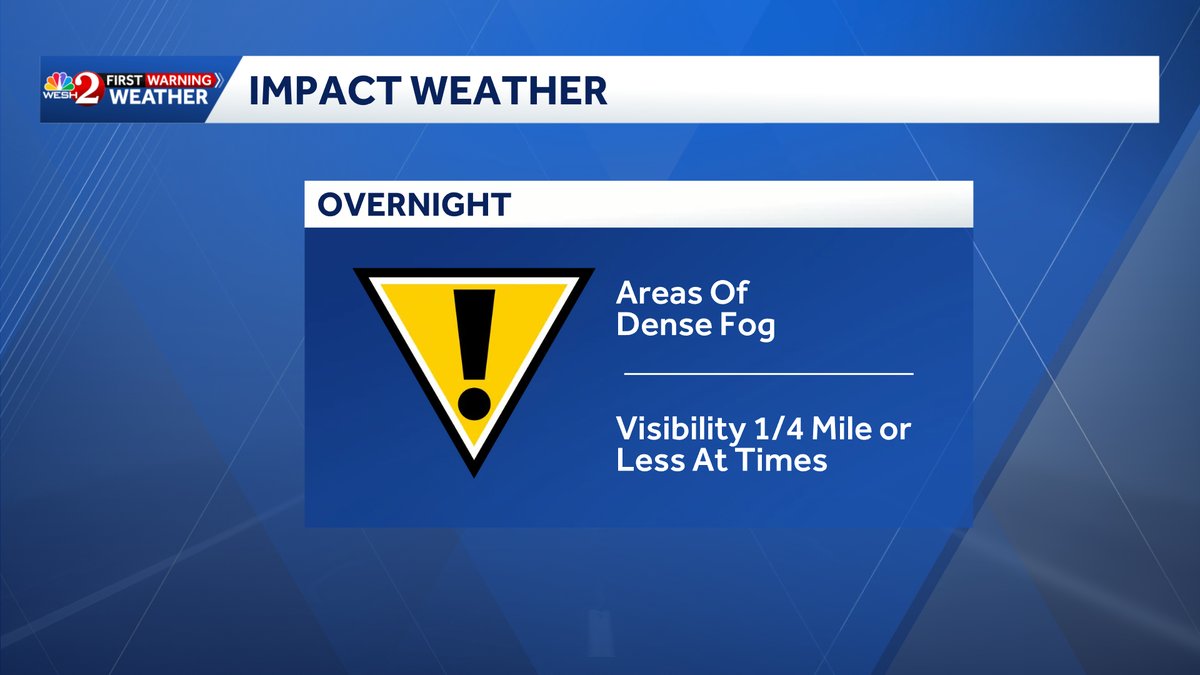
A dense fog advisory is in place for some Central Florida areas through Monday morning.The First Warning Weather Team is calling for Impact Weather until 10 a.m.Fog advisories are in place for Flagler and Volusia counties. The fog is expected to develop inland with the potential to bring visibility down to a ¼ mile across widespread areas, keeping Impact Weather across the region tonight and into the early morning. After the fog lifts, it will be a sunny and warm day with highs in the upper 70s.An arctic chill is set to bring freezing temperatures to the area starting Monday night, with lows in the 30s and 40s and wind chills even lower.First Warning WeatherStay with WESH 2 online and on-air for the most accurate Central Florida weather forecast.RadarSevere Weather AlertsDownload the WESH 2 News app to get the most up-to-date weather alerts.The First Warning Weather team includes First Warning Chief Meteorologist Tony Mainolfi, Eric Burris, Marquise Meda and Cam Tran.
, Fla. —
A dense fog advisory is in place for some Central Florida areas through Monday morning.
The First Warning Weather Team is calling for Impact Weather until 10 a.m.
Fog advisories are in place for Flagler and Volusia counties.
The fog is expected to develop inland with the potential to bring visibility down to a ¼ mile across widespread areas, keeping Impact Weather across the region tonight and into the early morning.

After the fog lifts, it will be a sunny and warm day with highs in the upper 70s.
An arctic chill is set to bring freezing temperatures to the area starting Monday night, with lows in the 30s and 40s and wind chills even lower.
This content is imported from Facebook.
You may be able to find the same content in another format, or you may be able to find more information, at their web site.
First Warning Weather
Stay with WESH 2 online and on-air for the most accurate Central Florida weather forecast.
Download the WESH 2 News app to get the most up-to-date weather alerts.
The First Warning Weather team includes First Warning Chief Meteorologist Tony Mainolfi, Eric Burris, Marquise Meda and Cam Tran.