
Impact Weather: Dense fog continues, cold front hits Central Florida this week
VISITING THE BETTER BUSINESS BUREAUS WEBSITE. WHETHER MAYBE YOU’RE OUT RUNNING ERRANDS TODAY, RETURNING SOME OF THE GIFTS THAT YOU GOT, OR HEADED BACK TO WORK. WE’RE DEALING WITH THIS FOG. AND AGAIN YESTERDAY IT WAS WIDESPREAD. ARE YOU SEEING THE SAME THING TODAY? YEAH, IT’S KIND OF MOVING IN FROM THE WEST. AND, YOU KNOW, IF YOU LIVE OUT EAST OF TOWN, YOU’RE LIKE, THIS IS FINE. YOU HAD THE FOG MAYBE LAST NIGHT COMING INTO DAYTONA BEACH, BUT EITHER WAY, IT’S ON THE MOVE. SO IT’S GOING TO BE IMPACTFUL THIS MORNING. THAT’S WHY WE’RE CALLING IT IMPACT WEATHER. SO TODAY WE START WITH THE DENSE FOG. THEN THIS AFTERNOON IT’S GUSTY AND WARM. AND THEN TOMORROW THROUGH MIDWEEK THERE IS A BIG PUSH OF FRIGID AIR. I MEAN IT’S GOING TO BE GETTING COLD. SO LOOKING AHEAD, TOMORROW’S HIGH TEMPERATURE STRUGGLES TO HIT 61 DEGREES. CELEBRATING OUR NEW YEAR’S EVE WILL WAKE UP TO WIND CHILLS IN THE 20S AND 30S AROUND TOWN, AND ONLY MAKING IT TO ABOUT 59 DEGREES. AND THEN NEW YEAR’S DAY COULD SEE A LITTLE BIT OF FROST. BUT IT’S GOING TO BE ANOTHER CHILLY DAY WITH TEMPERATURES IN THE 60S. TO GIVE YOU AN IDEA, THIS IS WEDNESDAY MORNING. THIS IS GOING TO BE THE COLDEST MORNING OF THE LOT. WILL WAKE UP TO 37 IN ORLANDO, 36 IN DAYTONA BEACH, 41 HERE IN PALM COAST, 33 IN LEESBURG, ABOUT 30 DEGREES IN THE VILLAGES IN OCALA. BUT YOU FACTOR IN A 15 TO 20 MILE PER HOUR WIND, AND IT WILL FEEL LIKE THE 20S NORTH 30S ALL THE WAY DOWN THROUGH BREVARD COUNTY. AND THAT’S BECAUSE OF A COLD FRONT THAT MOVES THROUGH THIS AFTERNOON INTO TONIGHT AND AFTERWARD. IT JUST LEAVES IN ITS WAKE THIS REAL KIND OF PERFECT SETUP, THIS INTERSTATE HIGHWAY OF COLD AIR TO MOVE IN. AND YOU CAN SEE THAT FRONT PASSING JUST BY LOOKING AT THE CLOUD CONDITIONS LATER TODAY THROUGH THE AFTERNOON AND EVENING, WE PAINT IN A 10% CHANCE OF A FEW QUICK PASSING SHOWERS. TEMPERATURES CLIMB INTO THE UPPER RANGE OF THE 70S, BUT ONCE THOSE TEMPERATURES START TO DROP OFF TONIGHT, THEY WILL ACCELERATE THEIR WAY DOWN AND THE BEST CHANCE OF RAIN IS GOING TO BE IN OUR NORTHERN AREAS. HERE’S FUTURECAST TO ILLUSTRATE THAT. LUNCHTIME TODAY. BEAUTIFUL SUNSHINE. THE FOG WILL HAVE BURNT OFF, BUT THE CLOUDS START ROLLING IN NORTH AND WEST. A FEW SHOWERS THERE THROUGH 3:00 IN THE VILLAGES 4:00 5:00. CAN’T RULE OUT A SPRINKLE OR TWO INTO THE METRO AND THEN IT ALL WORKS OUT BY ABOUT 8:00. BUT FOR NOW, NOTHING ON OUR FIRST WARNING LIVE RADAR IN TERMS OF RAIN. BELIEVE IT OR NOT, THOSE DOTS ARE ACTUALLY SHIPS THAT WE’RE TRACKING. SO THIS MORNING IT’S THE FOG. YOU CAN SEE IT HERE IN TAVARES. NOT SO BAD IN DAYTONA BEACH. NOT SO BAD PORT CANAVERAL, BUT THE BLANKET IS OVER. ORLANDO. SO FOR TODAY, 79, WHEN WE’RE DONE WITH THE FOG, IT’S GOOD TO GO. THEN TUESDAY, WEDNESDAY, THURSDAY, MUCH COLDER AIR DIVING IN. HIGHS IN THE 50S AND 60S. MORNING LOWS IN THE 30S AND 40S. AND WEDNESDAY MORNING IS IMPACT WEATHER BECAUSE OF THOSE WIND CHILLS THAT WORK IN. BUT IF THIS IS NOT YOUR BAG, I GET IT. LOOK AHEAD TO FRIDAY, SATURDAY, SUNDAY WE HEAL. FLORIDA IS GOING TO FLORIDA. WE’
Impact Weather: Dense fog continues, cold front hits Central Florida this week

Updated: 6:07 AM EST Dec 29, 2025
A dense fog advisory is in place for some Central Florida areas through Monday morning.The First Warning Weather Team is calling for Impact Weather until 10 a.m.Fog advisories are in place for Flagler and Volusia counties. The fog is expected to develop inland with the potential to bring visibility down to a ¼ mile across widespread areas, keeping Impact Weather across the region tonight and into the early morning. After the fog lifts, it will be a sunny and warm day with highs in the upper 70s.An arctic chill is set to bring freezing temperatures to the area starting Monday night, with lows in the 30s and 40s and wind chills even lower.First Warning WeatherStay with WESH 2 online and on-air for the most accurate Central Florida weather forecast.RadarSevere Weather AlertsDownload the WESH 2 News app to get the most up-to-date weather alerts.The First Warning Weather team includes First Warning Chief Meteorologist Tony Mainolfi, Eric Burris, Marquise Meda and Cam Tran.What is Impact Weather?Impact Weather suggests weather conditions could be disruptive or a nuisance for travel and day-to-day activities.What is a Severe Weather Warning Day?A Severe Weather Warning Day suggests weather conditions that could potentially harm life or property.
A dense fog advisory is in place for some Central Florida areas through Monday morning.
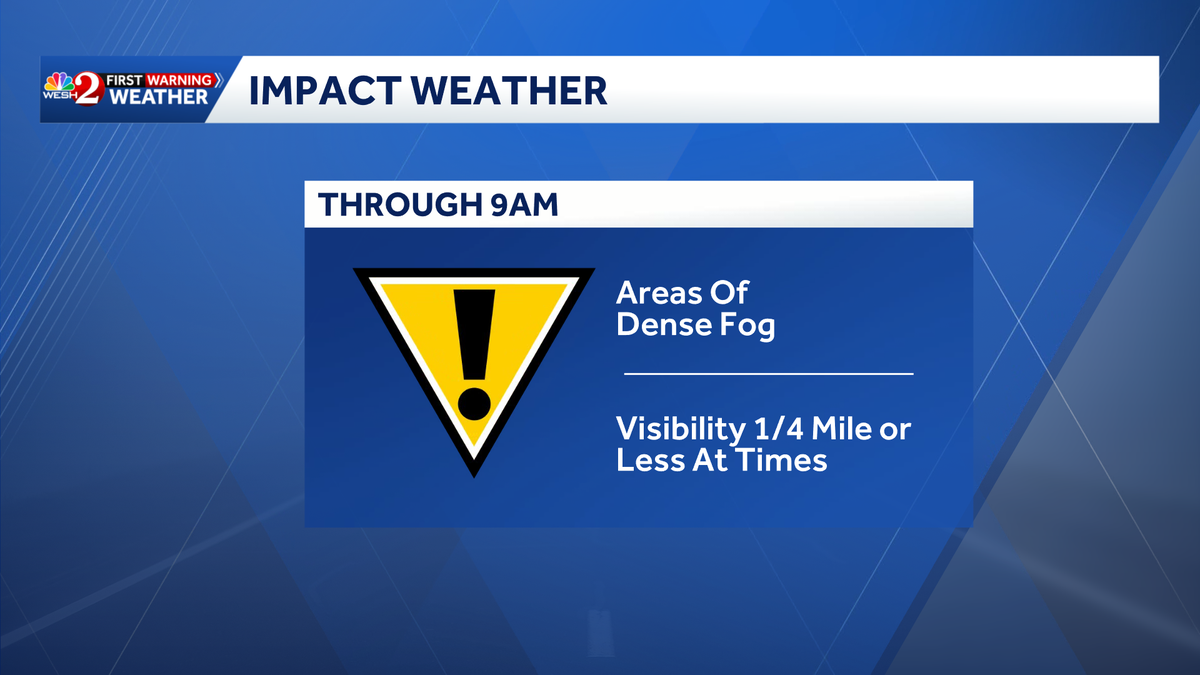
The First Warning Weather Team is calling for Impact Weather until 10 a.m.
Fog advisories are in place for Flagler and Volusia counties.
The fog is expected to develop inland with the potential to bring visibility down to a ¼ mile across widespread areas, keeping Impact Weather across the region tonight and into the early morning.
[image id=’bebdc7e2-7d5a-4eff-a2a8-a9fa53b26a7f’ mediaId=’5d561b56-0d77-40c6-a8be-7f7de8d39488′ align=’center’ size=”medium” share=”true” caption=” expand=” crop=’original’][/image]
After the fog lifts, it will be a sunny and warm day with highs in the upper 70s.
An arctic chill is set to bring freezing temperatures to the area starting Monday night, with lows in the 30s and 40s and wind chills even lower.
[facebook align=’center’]https://www.facebook.com/TMainolfiWESH/posts/pfbid02CnabuEKbczb4gWtDjHVH86Xuq5xb2Zq3nAMUm9DCHLUAeED6ZQf5zDALL6x232hJl[/facebook]First Warning Weather
Stay with WESH 2 online and on-air for the most accurate Central Florida weather forecast.
Download the WESH 2 News app to get the most up-to-date weather alerts.
The First Warning Weather team includes First Warning Chief Meteorologist Tony Mainolfi, Eric Burris, Marquise Meda and Cam Tran.
[related id=’22e90874-82c0-4abe-8c16-3dffca4eaf01′ align=’center’ source=””][/related]
What is Impact Weather?
Impact Weather suggests weather conditions could be disruptive or a nuisance for travel and day-to-day activities.
What is a Severe Weather Warning Day?
A Severe Weather Warning Day suggests weather conditions that could potentially harm life or property.