
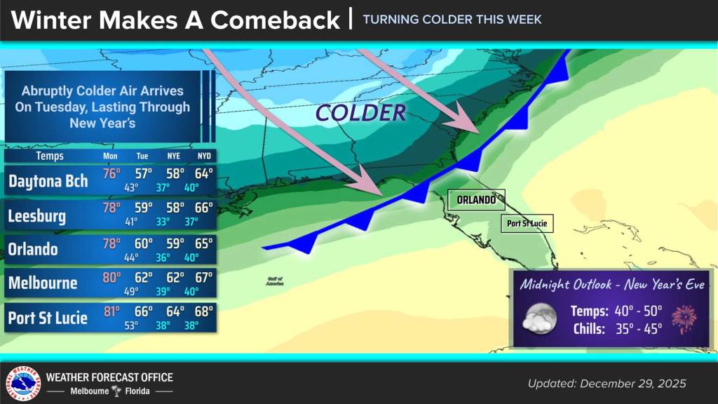
Central Florida can enjoy one more sunny day, but a cold front will drop temperatures Monday night bringing frigid conditions that will last into the new year, according to the National Weather Service.
Monday highs will hit the upper 70s and low 80s across the region during the day under sunny skies, similar to weather the area has enjoyed for the last couple of weeks. Fog remains an issue, though, with a dense fog advisory for Volusia, Lake, Seminole, Orange, Osceola and Brevard counties through 10 a.m.
Winds of 10-15 mph will kick up with higher gusts during the day as a strong cold front moves first into Volusia and Lake counties early Monday evening and then into South Florida by Tuesday morning.
Overnight lows could drop into the upper 30s around northwest Volusia and north Lake County with low to mid 40s for coastal Volusia, north Brevard and central Osceola County. Upper 40s and low 50s will be felt farther south and east.
Winds will transition to northwest overnight and could bring wind chill readings near sunrise in the mid to upper 30s north and west of Interstate 4 and low to mid 40s farther south.
The cold will continue the rest of the week as surface high pressure moves into the region from the northwest keeping 10-15 mph winds on Tuesday during the day that will taper off by evening. Highs will hit the upper 50s north of I-4 with low to mid 60s farther south.
Tuesday night will likely be the coldest of the week with temperatures in the 30s expected across the region.
Areas north and west of I-4 and some rural locations in southern Osceola County could see the low 30s with upper 30s across most other areas, although the Space Coast could be limited to the low 40s.
The wind chill will be lowest with feels-like temperatures Tuesday overnight into Wednesday morning that could be in the upper 20s to low 30s across the region.
A Cold Weather Advisory may be necessary and the NWS could issue a Freeze Watch for Tuesday overnight as well.
New Year’s Eve on Wednesday will keep the cooler, dry air mass into the new year.
Wednesday temps will mirror Tuesday, and perhaps be a few degrees cooler, with Thursday highs climbing into the 60s and Friday’s into the upper 60s and low 70s as a warming trend will bring the region back to the recent pleasant days by Saturday through next Monday.
The wind chill on New Year’s Eve into New Year’s Day could still be a concern with feels-like temperatures in the mid to upper 30s for much of the region.