
Chilly weather grips Central Florida
VIOLATION. ALL RIGHT, WELL, LISTEN. SO THIS MORNING, IT’S STARTING TO FEEL LIKE THE HOLIDAYS, AS WE WOULD HOPE FOR. IT IS CHILLY, BUT IT’S GOING TO BE GETTING EVEN CHILLIER TONIGHT OUTSIDE LIV. I DO WANT TO SHOW YOU OUR TOWER CAM NETWORK. THIS IS OVER IN VOLUSIA COUNTY. WE STILL HAVE A LITTLE BIT OF CLOUD COVER AND THAT WILL BE KIND OF HERE OR THERE THROUGH THE DAY. 47 DEGREES. OUR CURRENT TEMPERATURE IN NEW SMYRNA BEACH. IT’S 50 DEGREES IN ORLANDO, 46 IN LEESBURG AND 43 IN OCALA. THESE READINGS ARE RUNNING ABOUT FIVE, TEN, EVEN 15 DEGREES COOLER THAN THEY WERE YESTERDAY. AND WE’RE JUST NOT MOVING A TON. AVERAGE HIGH TEMPERATURE THIS TIME OF YEAR IS 72 DEGREES, SO WE WON’T EVEN BE IN THE BALLPARK 59 DEGREES. OUR HIGH TEMPERATURE IN ORLANDO, WHICH MEANS THAT WE’RE JUST NOT MOVING MUCH BECAUSE TEMPERATURES ARE NOT ALL THAT DIFFERENT THAN US RIGHT NOW. 57 DEGREES IN LEESBURG, 55 IN OCALA, 56 FOR PALM COAST AND 61 IN TITUSVILLE. IT’S GOING TO BE A NICE CHILLY BREEZE ALL DAY. WE’LL HAVE CLOUDS AND SUNSHINE IN, BUT THEN TONIGHT, THAT’S WHEN THE REAL CHILL ARRIVES. WE HAVE FREEZE WATCHES POSTED FOR INLAND VOLUSIA, LAKE MARION, SUMTER COUNTIES AND OF COURSE POINTS TO THE NORTH. A FREEZE WATCH MEANS THAT WE MAY GET INTO THE BALLPARK OF FREEZING FOR THE REST OF US. WE HAVE COLD WEATHER ADVISORIES, AND THAT IS BECAUSE OF THE WIND CHILL THAT’S GOING TO BE PLAYING IN FOR TONIGHT. AND WHILE IT’S GOING TO BE COLD, WE DON’T EXPECT RECORD TEMPERATURES FORECAST ON THE LEFT OR RECORDS ON THE RIGHT. WE’RE NOT EVEN GOING TO BE CLOSE. ALTHOUGH LOOKING AT THIS, I GOT TO TELL YOU, I DON’T REMEMBER THE YEAR 2000 BEING ALL THAT COLD, BUT THESE RECORDS WOULD SAY OTHERWISE. IT WAS A CHILLY, CHILLY DAY THAT YEAR. APPARENTLY TOMORROW MORNING WE’LL WAKE UP TO 37 IN THE CITY, 33 HERE IN LEESBURG, 30 DEGREES IN THE VILLAGES AND 28 IN OCALA. SO I AM FORECASTING A FREEZE IN OUR NORTHWESTERN AREAS. AND WHILE WE WON’T GET TO FREEZING IN THE METRO, LOOK AT THE WIND CHILLS. THIS IS WHY WE’RE CALLING IT IMPACT WEATHER TOMORROW MORNING, BECAUSE IT WILL FEEL LIKE 32. IN ORLANDO, 25 IN THE VILLAGES, 25 IN WILDWOOD AND 29 IN DAYTONA BEACH. SO WE DEFINITELY WANT TO BE BUNDLED UP OUT THE DOOR IN THE MORNING. SO COLD TEMPERATURES AND WIND CHILLS DEFINITELY GOING TO BE WITH US AT THE MOMENT. THE THREAT OF FROST IS LOW. HOWEVER, WE DO HAVE TO SEE HOW THE WINDS PLAY OUT TOMORROW NIGHT INTO THURSDAY MORNING. WE MAY HAVE TO START WORKING INTO SOME FROST EITHER WAY. TOMORROW AFTERNOON WE WARM UP. NOT MUCH, BUT WE WARM UP FROM THE 30S TO THE 50S AND LOWER 60S. AND FOR TOMORROW EVENING, PLANS. IT IS NEW YEAR’S EVE, AFTER ALL. WE’RE WATCHING THOSE TEMPERATURES DROP. 9 P.M. KIDS COUNT DOWN TO 47 DEGREES AND IT’S 43 AT 1159. AFTER THAT, WE START THE CLIMBING TREND. NEW YEAR’S DAY 66, THEN 70 ON FRIDAY AND FOR THE WEEKEND
A cold front has arrived, bringing significantly colder temperatures and marking the start of a series of days that will require jackets and sweatshirts. Morning temperatures have dropped into the 30s and 40s, with highs expected to reach near 60 degrees. Tonight feels-like temperatures are predicted to plummet into the 20s and 30s, creating impact weather conditions for Wednesday morning.First Warning Weather Stay with WESH 2 online and on-air for the most accurate Central Florida weather forecast.RadarSevere Weather AlertsDownload the WESH 2 News app to get the most up-to-date weather alerts. The First Warning Weather team includes First Warning Chief Meteorologist Tony Mainolfi, Eric Burris, Marquise Meda and Cam Tran.
ORLANDO, Fla. —
A cold front has arrived, bringing significantly colder temperatures and marking the start of a series of days that will require jackets and sweatshirts.
Morning temperatures have dropped into the 30s and 40s, with highs expected to reach near 60 degrees.
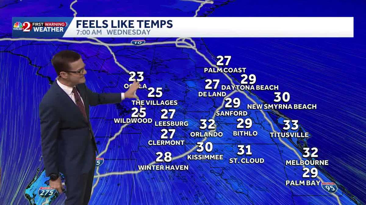
Tonight feels-like temperatures are predicted to plummet into the 20s and 30s, creating impact weather conditions for Wednesday morning.
First Warning Weather
Stay with WESH 2 online and on-air for the most accurate Central Florida weather forecast.
Download the WESH 2 News app to get the most up-to-date weather alerts.
The First Warning Weather team includes First Warning Chief Meteorologist Tony Mainolfi, Eric Burris, Marquise Meda and Cam Tran.