
NBC5 meteorologists are tracking a winter storm, set to bring widespread snowy and slippery roads by Thursday morning across Vermont and Northern New York.Snow timing and falling temperaturesSteady valley rain and mountain snow begins Wednesday evening, as temperatures linger in the 30s and 40s.Colder air arrives overnight, with temperatures dropping below freezing in the Champlain Valley by the Thursday morning commute and a flip to snow happening by then. Areas south and east stay above freezing with a few rain showers. Expect a layer of ice to be covered with fresh snow Thursday morning, especially in northern New York and the Champlain Valley, making for tough travel.Temperatures continue to fall throughout Thursday, reaching the teens and 20s by evening commute time, as snow showers linger.Snow totalsVariable snow totals are expected Wednesday night into Thursday, with several inches in northern New York and only a light accumulation south and east of the Champlain Valley.Northern New York Totals:Many towns can expect 4 to 8 inches, especially in the St. Lawrence Valley and Adirondacks. Best shot at 8 inches or more towards Potsdam and Massena. A general 2 to 4 inch amount expected along the Adirondack Coast.Northern Vermont and New Hampshire Totals:A widespread to 2 to 4 inches in the Champlain Valley, towards the northern Green Mountain spine. A dusting to 2 inches for most of the Northeast Kingdom, towards the Montpelier area. Expect very little accumulation south of Randolph.Southern Vermont and New Hampshire Totals:A general dusting to a couple inches expected near the southern Green Mountain spine. Little to no accumulation from Lebanon to Brattleboro, along the I-91 corridor.Want more local news? Download our NBC5 mobile app for iOS and Android.For the latest weather coverage for your area, click here. Stay updated with alerts in the myNBC5 app, which you can download here.For the best weather information and Vermont and northern New York’s Certified Most Accurate forecast, watch NBC5 News by streaming at this link.Don’t forget to follow NBC5 News on Facebook, X (formerly Twitter), and Instagram.Follow the NBC5 First Warning Weather team on social media:Chief Meteorologist Tyler Jankoski Facebook | X | InstagramMeteorologist Ben Frechette Facebook | X | InstagramMeteorologist Matt DiLoreto Facebook | XMeteorologist Andrew Grautski Facebook | XMeteorologist Marissa Vigevani Facebook | X
SOUTH BURLINGTON, Vt. —
NBC5 meteorologists are tracking a winter storm, set to bring widespread snowy and slippery roads by Thursday morning across Vermont and Northern New York.
Snow timing and falling temperatures
Steady valley rain and mountain snow begins Wednesday evening, as temperatures linger in the 30s and 40s.
Colder air arrives overnight, with temperatures dropping below freezing in the Champlain Valley by the Thursday morning commute and a flip to snow happening by then. Areas south and east stay above freezing with a few rain showers.

Expect a layer of ice to be covered with fresh snow Thursday morning, especially in northern New York and the Champlain Valley, making for tough travel.
Temperatures continue to fall throughout Thursday, reaching the teens and 20s by evening commute time, as snow showers linger.

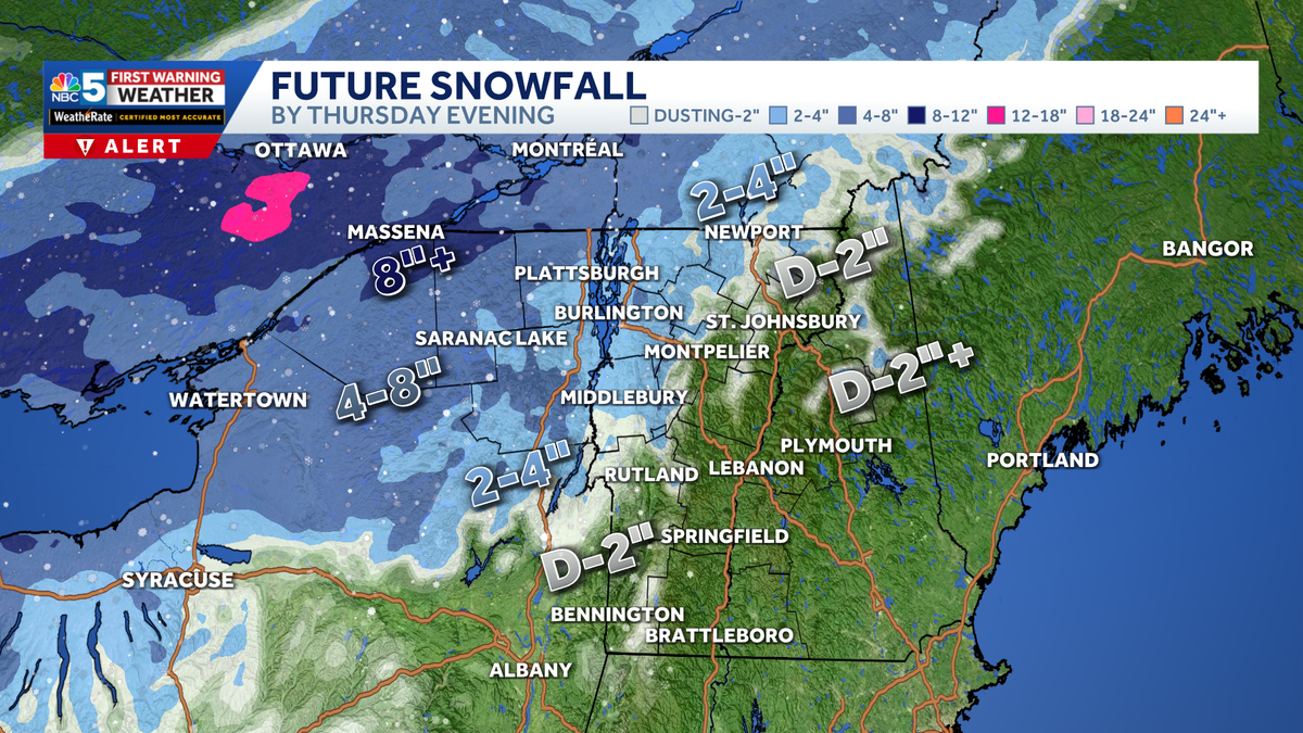
Snow totals
Variable snow totals are expected Wednesday night into Thursday, with several inches in northern New York and only a light accumulation south and east of the Champlain Valley.
Northern New York Totals:
Many towns can expect 4 to 8 inches, especially in the St. Lawrence Valley and Adirondacks. Best shot at 8 inches or more towards Potsdam and Massena. A general 2 to 4 inch amount expected along the Adirondack Coast.

Northern Vermont and New Hampshire Totals:
A widespread to 2 to 4 inches in the Champlain Valley, towards the northern Green Mountain spine. A dusting to 2 inches for most of the Northeast Kingdom, towards the Montpelier area. Expect very little accumulation south of Randolph.

Southern Vermont and New Hampshire Totals:
A general dusting to a couple inches expected near the southern Green Mountain spine. Little to no accumulation from Lebanon to Brattleboro, along the I-91 corridor.

Want more local news? Download our NBC5 mobile app for iOS and Android.
For the latest weather coverage for your area, click here. Stay updated with alerts in the myNBC5 app, which you can download here.
For the best weather information and Vermont and northern New York’s Certified Most Accurate forecast, watch NBC5 News by streaming at this link.
Don’t forget to follow NBC5 News on Facebook, X (formerly Twitter), and Instagram.
Follow the NBC5 First Warning Weather team on social media: