
STATEN ISLAND, N.Y. — New York City will be hit with a powerful snowstorm this weekend. As meteorologists monitor the system, forecasts are emerging revealing the potential for up to a foot of snow.
Tom Kines, a senior meteorologist with AccuWeather, explained that the further north the storm gets, the more snow the city will receive.
“It’s starting to look more and more like the storm is going to get far enough north to be an impactful storm for your area [Staten Island],” Kines said.
The storm will arrive sometime between late Saturday night and Sunday morning and will persist throughout the day Sunday before tapering off Monday morning. Kines suspects the Monday morning commute will “be a lot slower than usual.”
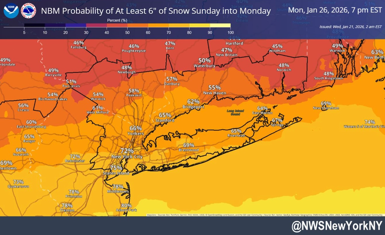
Although precise accumulation amounts remain unknown Wednesday morning, Kines told the Advance/SILive.com that there is “a pretty good shot of 6 inches.”
Overall, Kines foresees the city receiving between 6 and 12 inches of snow.
Bryan Ramsey, a meteorologist with the National Weather Service, said that “the confidence is increasing” that snowfall amounts will be 6 inches or greater with this system.
“Whether it’s 6 inches or 10 inches, it’s going to be impactful, okay? People are going to be shoveling, snow crews will be plowing and it’s going to be a mess,” Kines said.
Given that Staten Island is at the southern end of the city, there’s a good chance the borough will see among the highest snowfall tallies in the city.
“Since you’re in Staten Island, your odds are a little better than, you know, north of New York City,” added Ramsey. “So where we see some of our highest totals could be in your area.”
While the Island is expected to see some more snow, that does not mean areas upstate will be spared. According to Kines, the snowfall is forecast to extend from Albany on south.
Will track shift?
Although the city could receive up to a foot of snow, Kines explained that the track of the storm could shift depending on whether the high pressure to the city’s north holds or succumbs to the strengthening storm.
“It’s going to be a battle to see who wins out. If the high pressure wins out there will be less in the way of snow,” Kines noted.
“If the southern storm gets stronger and pushes the high pressure area out of the way, that’s how the storm gets farther north and we get a very significant snowfall,” he added.
As of Wednesday morning, Kines believes the snow that will fall on the city will be a “dry, fluffy snow” that is easier to shovel. However, if the storm pushes too far north, it will bring warmer air and the potential for sleet or freezing rain. This wetter snow would be more difficult to manage.
Temperatures on Sunday are not expected to exceed 20 degrees and temperatures on Monday will likely reach the mid-20s, said Kines. He noted that cold temperatures will persist in the wake of the storm.
“I know tomorrow will be up in the 40s, that might be the last time we see 40s for many days,” he explained.