A whopper of a winter storm is set to impact a large chunk of the U.S. – from Texas to the East Coast – this weekend. It’s too early to predict how much snow we may get, but the models are aligning for significant totals.
Much depends on the storm track.
Here are some headlines to watch:
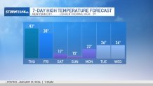
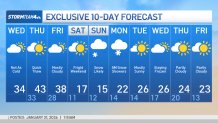
Bitter cold returns Saturday, but it’s dry
After a two-day respite, bitter cold returns to the tri-state area Saturday, setting the stage for Sunday’s snowstorm. Highs of 17 and 15 are expected on Saturday and Sunday, respectively.
Saturday, at least, will be dry.
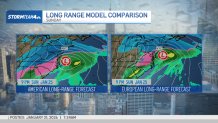
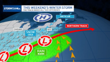
The track makes all the difference
It’s still too early to talk potential totals for the region. Winter weather advisories, watches, and warnings from the National Weather Service are expected. Right now, those watches are southwest of us.
The models are showing increasing confidence that Sunday will bring a major snow event. The European long-range forecast model depicts more of a northerly track. Its American counterpart is hedging the track south.
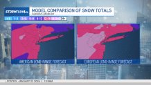
As the tracks suggest, the European model is much more bullish on snow, with an estimated 12-plus inches for much of the tri-state. The American model remains more modest, at 3 to 5 inches.
Timing: What do we know?
We’re looking at the storm to start late Sunday morning, with impacts increasing steadily over the course of the day.
New York City’s Office of Emergency Management says current guidance suggests the snow may start Sunday afternoon or evening and continue into Monday. With colder air in place, any snow that falls will stick.
Much remains uncertain about the storm’s timing this far out.
Cross-country travel impacts
Significant travel impacts are expected from Texas to the East Coast. The sweeping storm has already triggered winter weather advisories in the South and will likely trigger local ones in the days to come.
Airlines are expected to experience heavy delays. Travel will be severely hampered during the worst of the storm, which is expected Sunday afternoon into the evening.
No announcements on bridge or tunnel closures or related traffic changes have been made yet. Those will likely come a day or so before the storm hits, once the track and projections are more solidified.
Another Arctic blast moves in — and stays
Any snow that falls over the weekend will stick for the foreseeable future.
Bitter cold ensconces the tri-state area through the snowfall, dropping to a high of 15 degrees on Sunday, which is the brunt of the storm. It improves a bit, to the low 20s, on Monday and stays bitterly cold through next week.