
STATEN ISLAND, N.Y. — New York City may end up with a foot of snow from the weekend storm set to begin early Sunday morning. However, there’s also the possibility that the city escapes with less than half of that.
Alan Reppert, a senior meteorologist with AccuWeather, explained the situation to the Advance/SILive.com on Friday evening.
Due to an expected mixture of precipitation, Reppert foresees the city receiving between 4 and 8 inches of snow. However, if that mixing is minimal, accumulation could be higher, he said.
Sleet may mix in, especially Sunday night, and if that doesn’t mix in as much, we’ll be looking at a foot of snow, according to the weather expert.
The factor that will ultimately determine the final snowfall tally is an area of low pressure off the coast.
Should the low pressure track closer to the city, the city will likely see more mixing and therefore less accumulation. If the low pressure shifts farther to the south and the east, then city residents will see more snow, according to Reppert.
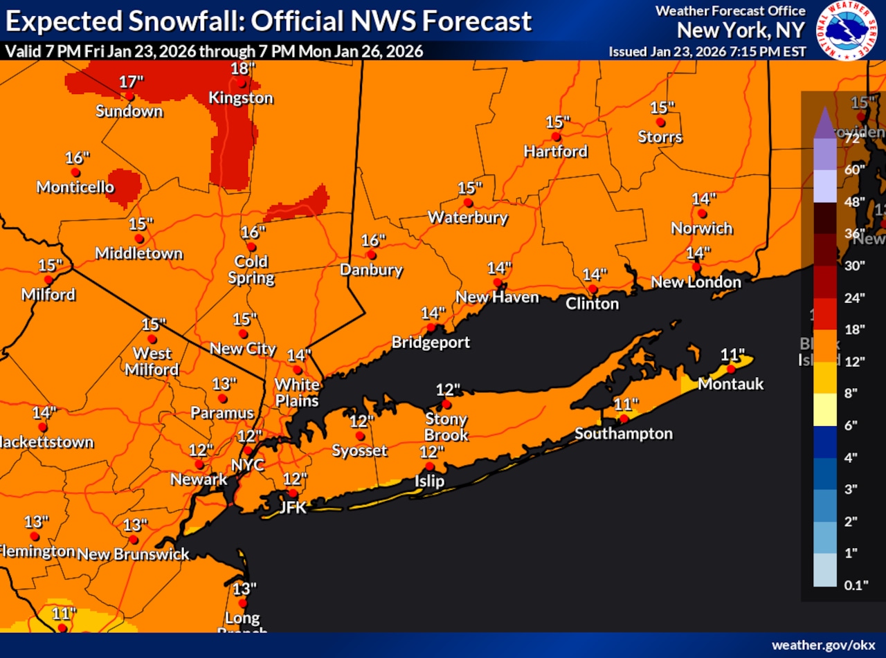
A National Weather Service graphic issued at 7:17 p.m. Friday revealed that the weather service anticipates around 12 inches of snowfall for the city. There is a 70% to 80% probability that Staten Island will receive at least 8 inches of snow, as forecast by the weather service.
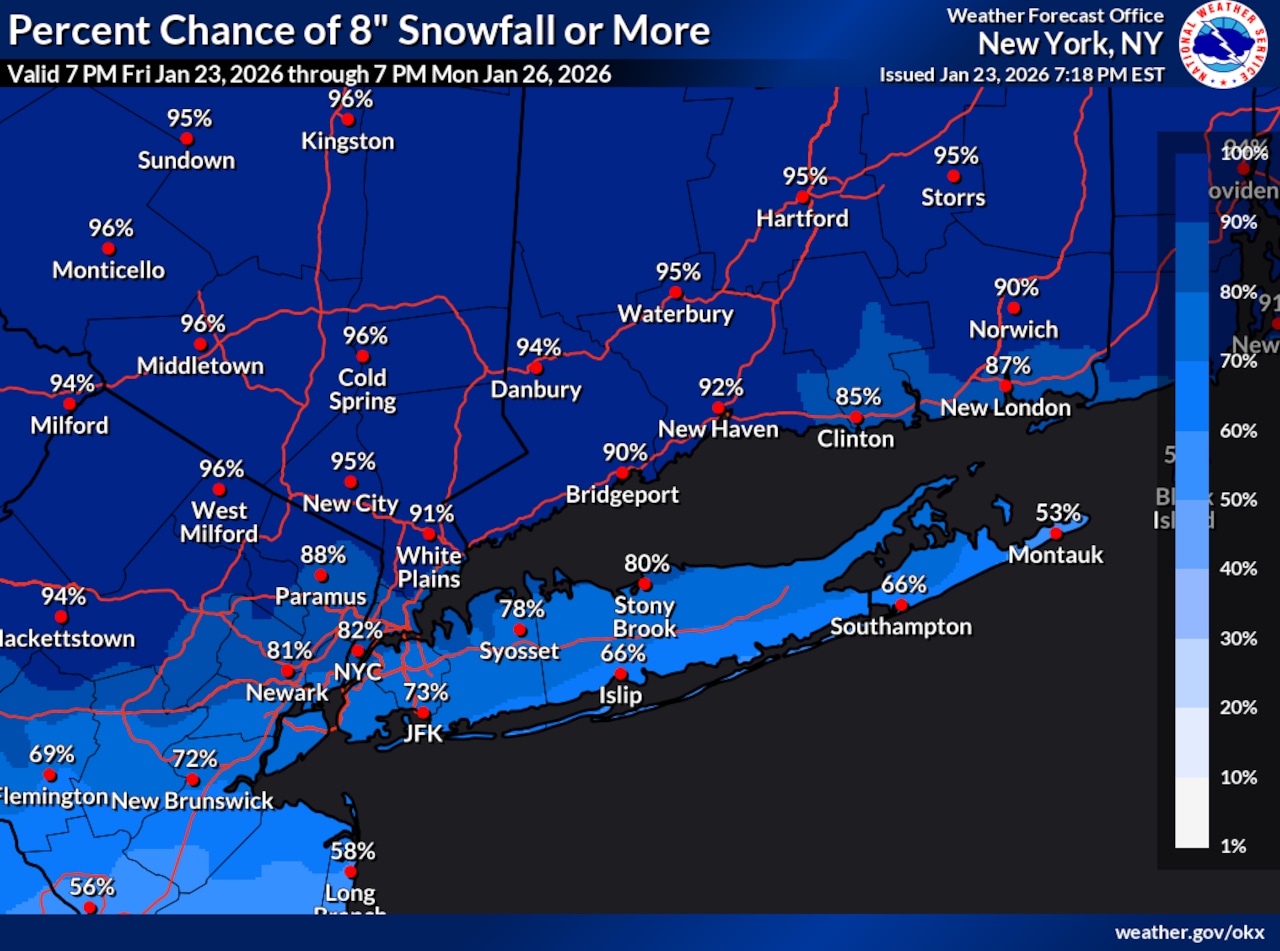 This National Weather Service graphic shows there is a 70% to 80% probability of at least 8 inches of snow falling in New York City from Friday, Jan. 23, through Monday, Jan. 26, 2026.(National Weather Service)
The bulk of the snow is forecast to fall Sunday into Sunday night. Some snow will linger into Monday morning, but Reppert expects that precipitation to taper off “fairly quickly.”
Although wind does not look to play a significant role, Reppert said it will be “somewhat breezy” Sunday night into Monday. There could be some drifting of snow, but he does not foresee “a major wind event with this.”
City officials on alert
In anticipation of this storm, officials are issuing alerts and making preparations for any potential impacts.
The New York City Department of Sanitation has scheduled a Snow Alert to go into effect at 1 a.m. Sunday. The department began applying brine to city streets on Friday and is preparing resources for deployment when snow begins falling Sunday.
The weather service issued a Winter Storm Warning that will remain in effect from 3 a.m. Sunday through 6 p.m. Monday. The warning is issued when at least 6 inches of snow is expected within the span of 12 hours or at least 8 inches is forecast within 24 hours.
And given the forecast for poor road conditions, the New York City Emergency Management Department has issued a hazardous travel advisory for Sunday and Monday.
“We’re facing a major winter storm that could bring some of the heaviest snowfall New York City has seen in years, along with frigid temperatures and high winds,” said Mayor Zohran Mamdani. “City agencies are fully mobilized — our streets are being treated, our plow fleet is prepared, and outreach teams are working around the clock to ensure New Yorkers can stay safe and homeless New Yorkers can access shelter. I’m deeply grateful to the public servants who are putting in long, cold hours under tough conditions to help our city weather this severe winter weather. I urge everyone across the five boroughs to prepare ahead of the storm, stay off the roads once it begins, and follow updates through Notify NYC.”