NBC5 meteorologists are tracking a major winter storm impacting tens of millions across the United States. Vermont and New York will catch a piece of this storm, in the form of several inches of dry, powdery snow Sunday into Monday.Ahead of the storm, temperatures plunge below zero early Sunday morning, only reaching the single digits by afternoon.Sunday starts dry, with a mostly cloudy sky. Steady snow spreads into southern Vermont by late morning, expanding north to the Canadian Border by mid-afternoon.Widespread moderate to heavy snow continues Sunday evening and night. Impacts to schools, businesses, etc. are LIKELY Monday.Steady light snow continues Monday morning and afternoon, becoming more confined to the mountains by late in the day. The entire storm departs by Tuesday morning.Snowfall totals will be highest in central and southern Vermont, where over a foot of dry, powdery snow is expected. Locally higher amounts of 18-24″+ are likely near the Massachusetts border.Northern areas can expect a widespread 8 to 12 inches of powdery snow.Any snow that falls will stick around for many days on end — temperatures stay below freezing through the first weekend of February. Want more local news? Download our NBC5 mobile app for iOS and Android.STAY WEATHER-AWAREFor the latest weather coverage for your area, click here. Stay updated with alerts in the myNBC5 app, which you can download here.For the best weather information and Vermont and northern New York’s Certified Most Accurate forecast, watch NBC5 News by streaming at this link.Don’t forget to follow NBC5 News on Facebook, X (formerly Twitter), and Instagram.Follow the NBC5 First Warning Weather team on social media:Chief Meteorologist Tyler Jankoski Facebook | X | InstagramMeteorologist Ben Frechette Facebook | X | InstagramMeteorologist Matt DiLoreto Facebook | XMeteorologist Andrew Grautski Facebook | XMeteorologist Marissa Vigevani Facebook | X
NBC5 meteorologists are tracking a major winter storm impacting tens of millions across the United States. Vermont and New York will catch a piece of this storm, in the form of several inches of dry, powdery snow Sunday into Monday.
Ahead of the storm, temperatures plunge below zero early Sunday morning, only reaching the single digits by afternoon.

NBC5 News
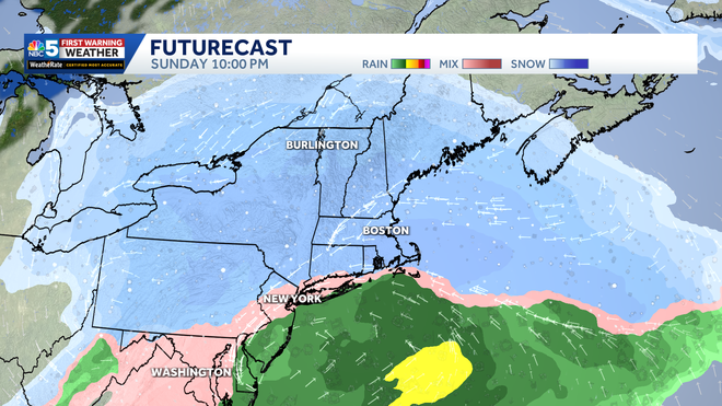
The height of the storm occurs Sunday night across northern New England and New York.
Sunday starts dry, with a mostly cloudy sky. Steady snow spreads into southern Vermont by late morning, expanding north to the Canadian Border by mid-afternoon.
Widespread moderate to heavy snow continues Sunday evening and night. Impacts to schools, businesses, etc. are LIKELY Monday.
Steady light snow continues Monday morning and afternoon, becoming more confined to the mountains by late in the day. The entire storm departs by Tuesday morning.

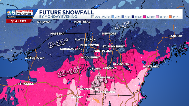
Snowfall totals will be highest in central and southern Vermont, where over a foot of dry, powdery snow is expected. Locally higher amounts of 18-24″+ are likely near the Massachusetts border.
Northern areas can expect a widespread 8 to 12 inches of powdery snow.

Hearst Owned
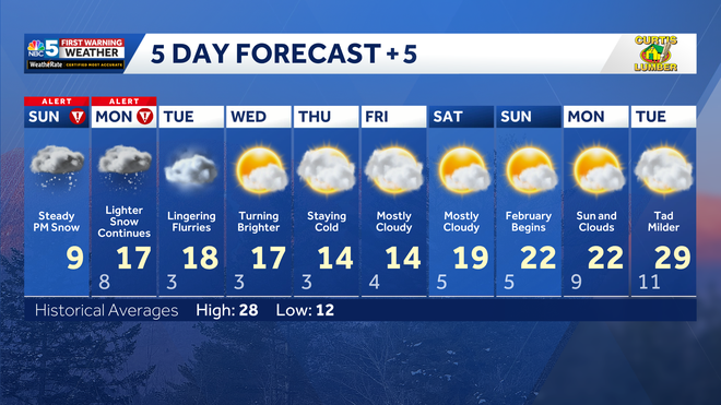
Our latest extended forecast.
Any snow that falls will stick around for many days on end — temperatures stay below freezing through the first weekend of February.
Want more local news? Download our NBC5 mobile app for iOS and Android.
STAY WEATHER-AWARE
For the latest weather coverage for your area, click here. Stay updated with alerts in the myNBC5 app, which you can download here.
For the best weather information and Vermont and northern New York’s Certified Most Accurate forecast, watch NBC5 News by streaming at this link.
Don’t forget to follow NBC5 News on Facebook, X (formerly Twitter), and Instagram.
Follow the NBC5 First Warning Weather team on social media:

