
NEW YORK – More winter weather may be on the way as forecasters track a potential weekend snowstorm that could strengthen into a major nor’easter.
What we know:
The National Weather Service (NWS) says confidence is growing that a powerful coastal storm will develop late this week, with the potential to bring snow, strong winds and bitter cold to the New York City area.
However, small changes in the storm’s track could make a big difference in who sees accumulating snow — and how much.
Here’s the latest on the storm.
SKIP TO: PREDICTIONS | FORECAST | BOMB CYCLONE | 5 DAY | LIVE WEATHER
Tracking the storm
What they’re saying:
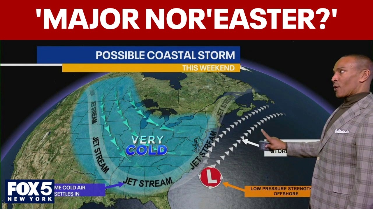
FOX 5 NY meteorologist Mike Woods says the region needs to watch the storm closely.
“If it’s a little further offshore, we’re left with less of an impact,” Woods said. “But if it’s a little closer to us, we could have a major nor’easter on our hands.”
Why you should care:
With a cold weather advisory in effect due to Arctic air already locked in place, conditions could support snow across New York, New Jersey and Connecticut.
Stay connected with FOX LOCAL. For winter storm coverage—Download Now. 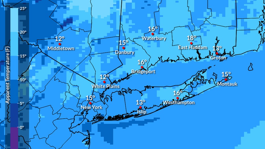
Cold weather continues on Wednesday. Highs will only be in the lower to middle 20s, but with the wind, the “warmest” it will feel is lower to middle teens.
What they’re saying:
FOX 5 NY’s meteorologist Mike Woods says the region needs to watch the storm closely.
“If it’s a little farther offshore, we’re left with less of an impact,” Woods said. “But if it’s a little closer to us, we could have a major nor’easter on our hands.”
Dig deeper:
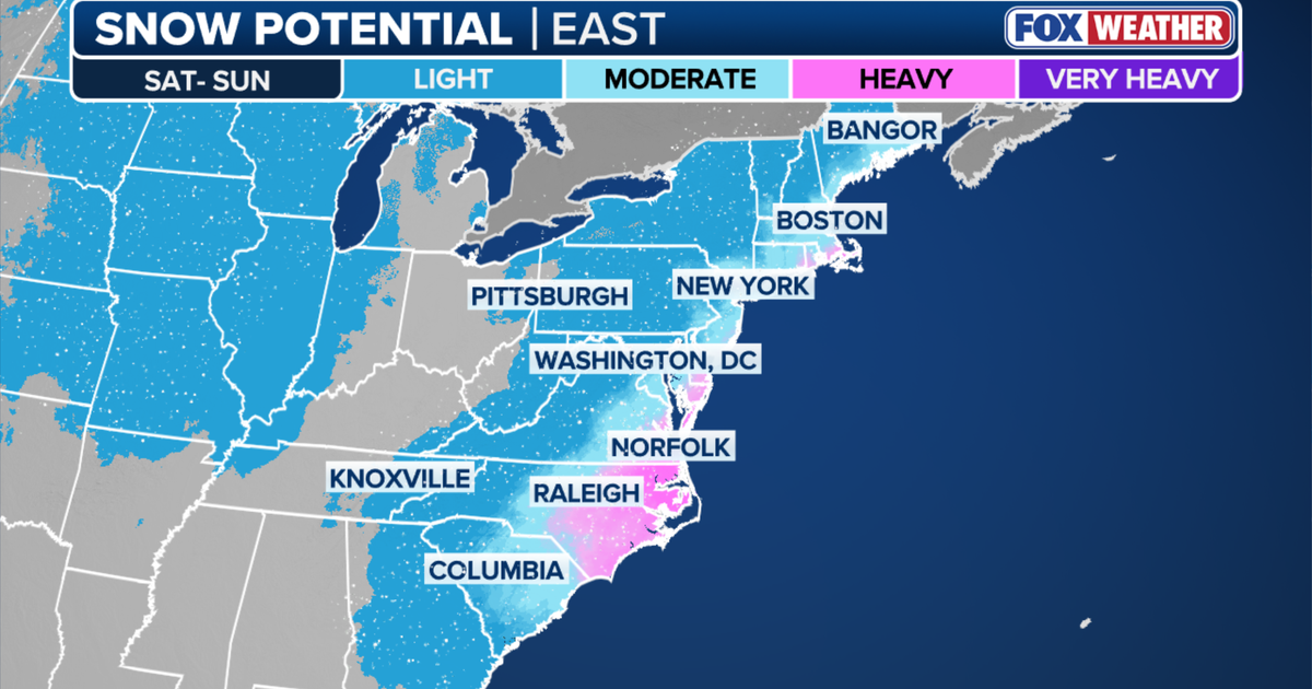
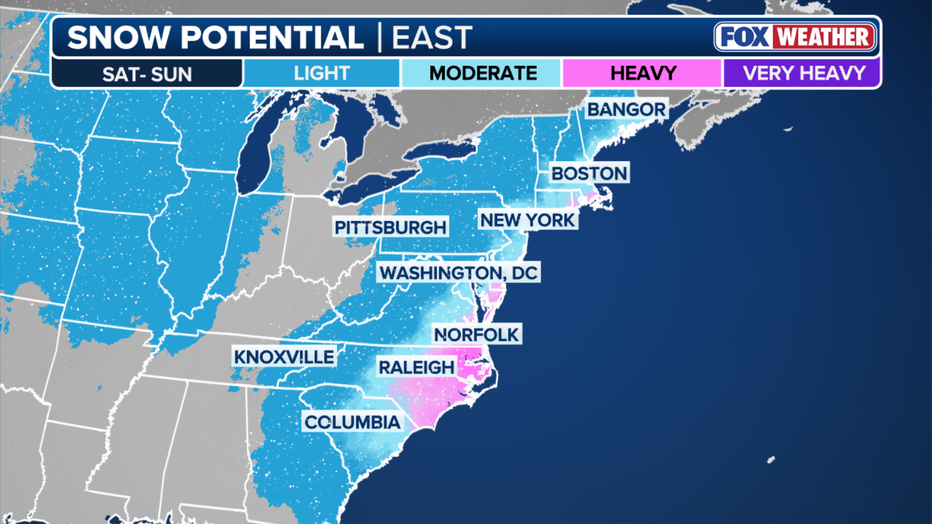
Woods says some forecast models currently show snow reaching parts of the tri-state area, particularly the Jersey Shore and the eastern end of Long Island, late Saturday into Sunday.
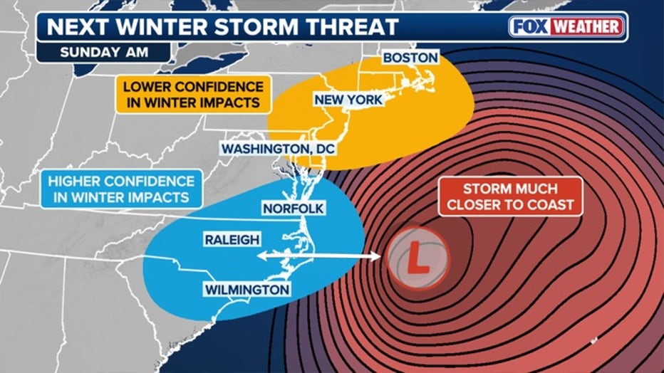
There is higher confidence that coastal areas of South Carolina, North Carolina and Virginia see winter impacts as low pressure area forms on the Southeast coast. (FOX Weather)
Other scenarios keep the storm farther offshore, limiting impacts for the city.
Forecasters emphasize that the exact track of the storm remains uncertain.
Even a shift of 50 to 100 miles could change precipitation types, snowfall totals or whether some areas see little to no snow at all.
Forecast guidance suggests snow could begin as early as Friday night in parts of the Southeast before spreading north.
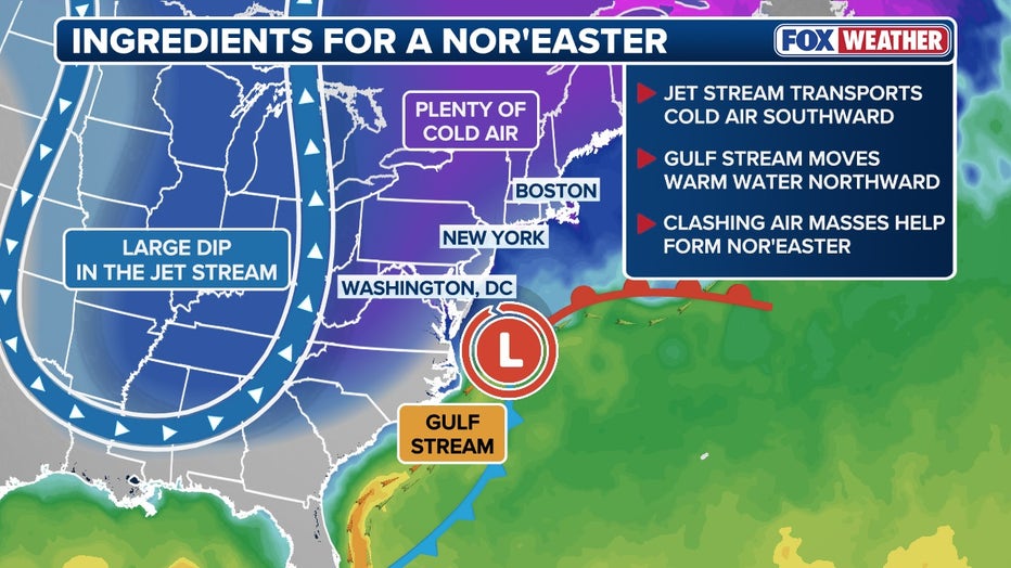
The setup includes very cold air already in place across the Northeast, combined with a developing coastal storm that could pull moisture northward.
Woods notes that temperatures will trend colder over the next several days, not warmer.
Possible nor’easter scenarios
(In this scenario, after the coastal low develops off the coast of the Carolinas and Virginia, the storm tracks past the “40/70 benchmark.” Which would likely produce significant snowfall along the I-95 corridor.(FOX Weather))
“We’ve got more shots of Arctic air coming through,” he said. “That’s why temperatures are actually going down instead of up.”
Wind chill advisories are already in effect across parts of the region, with feels-like temperatures dipping below zero in some areas.
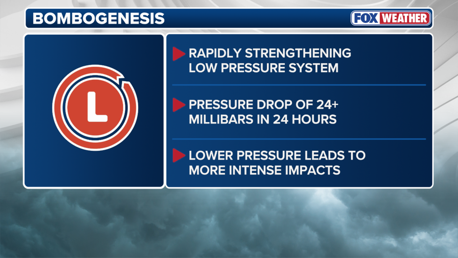
FOX Weather says the developing storm has a strong likelihood of rapidly intensifying, a process known as “bombing out,” which could turn it into a bomb cyclone.
Forecast models suggest the storm’s central pressure could drop dramatically as it moves offshore, a sign of rapid strengthening.
However, where that intensification occurs remains uncertain.
Meteorologists stress that the storm is still several days away, and multiple scenarios remain on the table.
What is a bomb cyclone?
A bomb cyclone forms through a process called bombogenesis, which occurs when a storm’s central pressure drops at least 24 millibars in 24 hours, according to FOX Weather.
Why is it so cold and snowy? 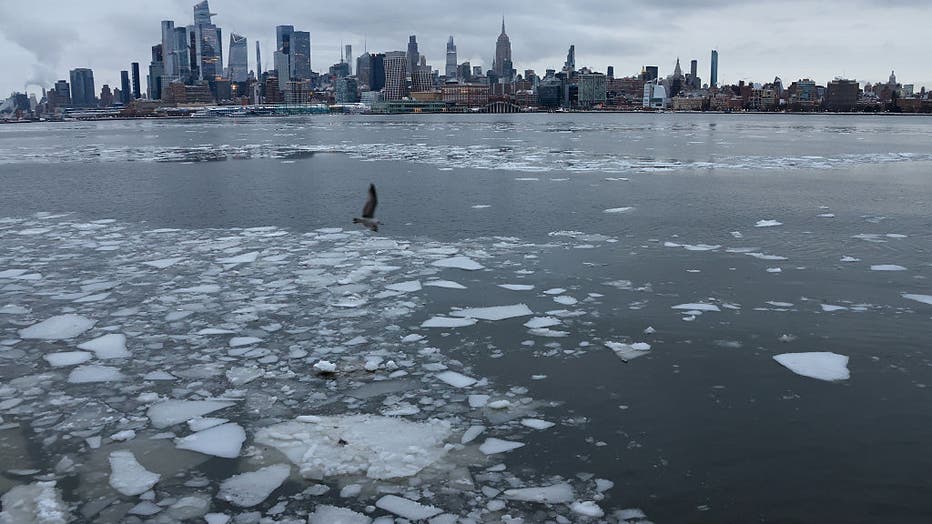
HOBOKEN, NJ – JANUARY 26: Chunks of ice float in the Hudson River in front of the skyline of midtown Manhattan and the Empire State Building in New York City on January 26, 2026, in Hoboken, New Jersey. (Photo by Gary Hershorn/Getty Images)
The backstory:
Forecasters say a pronounced dip in the jet stream is reinforcing cold air across much of the eastern United States while steering the storm farther south before it turns north.
A strong upper-level disturbance is expected to become embedded in the jet stream late this week, helping trigger the development of low pressure off the East Coast.
With cold air already in place, that combination raises the risk for snow if the storm moves close enough to the region.
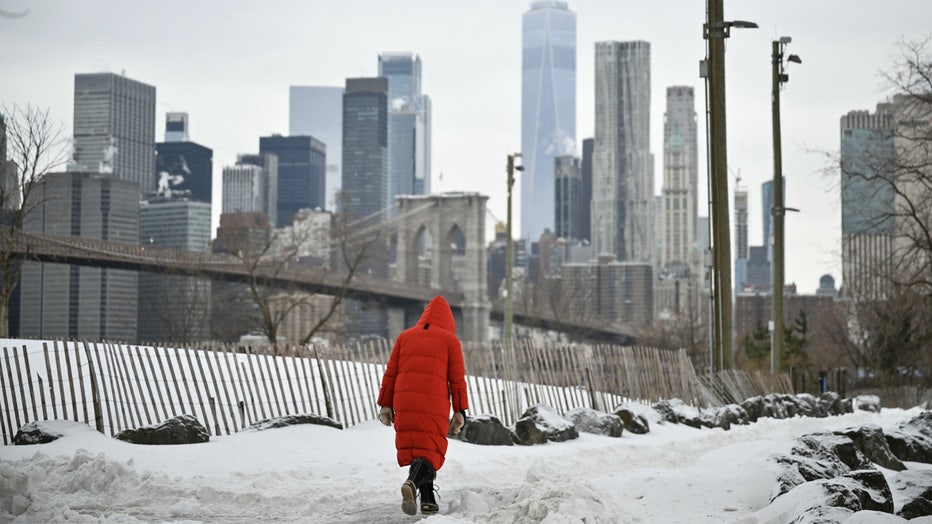
The Lower Manhattan skyline and Brooklyn Bridge are seen in the background as a woman walks through the snow in the Brooklyn borough of New York City on January 26, 2026. (Photo by ANGELA WEISS / AFP via Getty Images) ( )
What we don’t know:
Meteorologists say updates over the next several days will be critical in determining the storm’s impact on New York City and the surrounding area.
The biggest question remains the storm’s path after it moves through the Carolinas, with forecast models split on whether it will track far enough north to bring another weekend snow to the Northeast.
![]()
Wednesday: Bitterly cold but dry. Arctic air remains in place with sunshine and strong wind chills making it feel well below freezing across the tri-state area.
Thursday: Continued cold with increasing clouds. No precipitation expected, but the cold air sets the stage for potential weekend impacts.
Friday: Clouds increase as a coastal storm begins to organize off the Southeast coast. Snow develops across parts of the Carolinas and southern Virginia by Friday night. Conditions remain cold locally with precipitation still uncertain for NYC.
Saturday: Storm system moves north along the East Coast. Snow is possible in parts of New Jersey, Long Island and coastal areas, depending on the storm’s track. New York City remains in a “wait-and-see” zone.
Sunday: Potential for lingering snow, wind and cold if the storm tracks closer to the coast. A farther offshore track would limit impacts, while a closer path could bring a nor’easter with strong winds and accumulating snow.
Stay ahead of the snow with FOX 5’s expert meteorologists, streaming LIVE on FOX LOCAL. We’re streaming nonstop coverage with the newest forecasts, snow potential, and preparation tips—before the storm and all weekend long. Download FOX LOCAL for 24/7 weather coverage on your smart TV and mobile devices.
The Source: This report is based on information from the NWS, FOX 5 NY’s Mike Woods and FOX Weather.