
STATEN ISLAND, N.Y. — New York City will see some relief from freezing conditions next week, but before then, residents will need to bear with what are expected to be the coldest temperatures of the winter.
According to meteorologists, the city will likely experience a burst of snow and sub-zero conditions over the course of the weekend.
Thursday and Friday will be relatively mild, with forecast highs just below 30 degrees and lows in the mid to upper teens.
“There’s going to be another cold front that comes through Friday night, may be accompanied by some light snow, we could see maybe up to an inch in Staten Island, half inch to an inch,” David Stark, a meteorologist with the National Weather Service, told the Advance/SILive.com.
However, for Stark, that is not “the big story.” The real issue will be the dangerous cold temperatures that follow the snow.
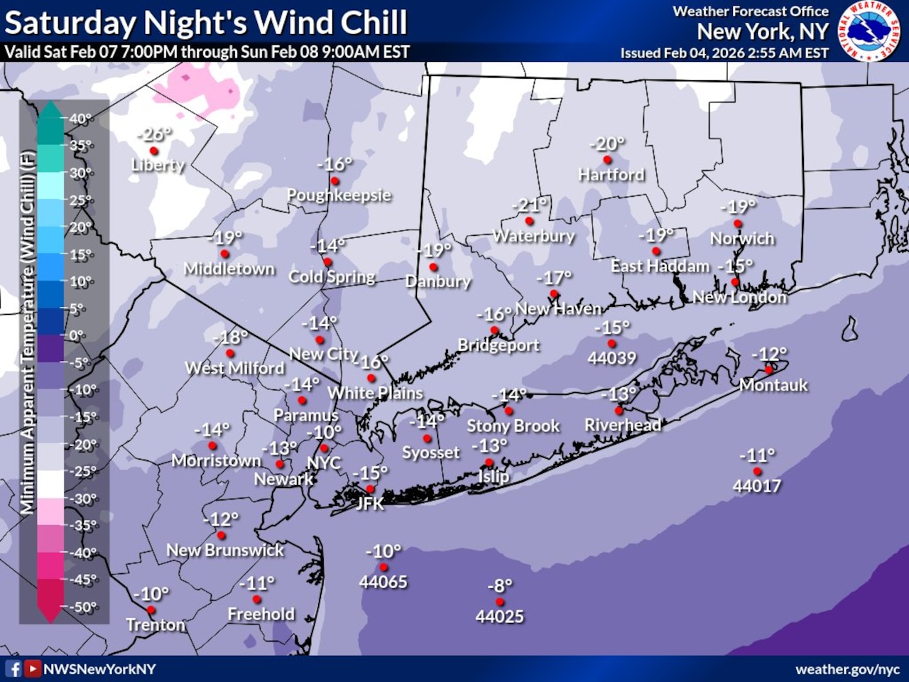 This National Weather Service graphic shows the forecast wind chill in New York City for Saturday, Feb. 7, 2026.(Courtesy of the National Weather Service)
Saturday will start out in the 20s before dropping “significantly” into the teens in the afternoon.
“Fairly strong sustained winds” and gusts will begin to make it feel as though it is below zero in the evening hours. Sustained winds in the evening could reach 20-30 mph and some gusts could even reach 50 mph, according to Stark.
In the evening, the actual air temperature will plummet to somewhere around 3 to 7 degrees on Staten Island, Stark said.
When you combine these temperatures with the forecast winds, you end up with a wind chill late Saturday night into early Sunday morning of -10 to -15 degrees Fahrenheit.
Despite a forecast improvement in the winds and temperatures in the 20s, Stark believes it will still feel around zero degrees Sunday afternoon.
Single digit temperatures Sunday night could feel below zero due to any lingering wind, he added.
The coldest temperature in Central Park so far this winter has been 9 degrees. Should temperatures reach the forecast low of 5 degrees Sunday morning, it will officially be the coldest conditions of the season. Additionally, the wind chills are likely to be the coldest of the winter, Stark noted.
Frostbite can occur on exposed skin in as little as 10 to 15 minutes in -20 degree conditions, Stark explained. While it will not get as cold, it serves as a reference point to demonstrate just how dangerous prolonged exposure to this weekend’s weather can truly be.
“But there is some relief coming,” Stark explained. “It looks like by Tuesday we should get back close to freezing and then there’s a chance about by midweek we could be in the mid to upper-30s for next Wednesday and Thursday.”
Although still below average for this time of year, those temperatures could result in some much anticipated melting for those residents tired of the lingering snow from Winter Storm Fern.
AccuWeather senior meteorologist John Feerick foresees much of the same conditions forecast by Stark.
Like Stark, Feerick believes the city could see up to an inch of snow. He also forecasts heightened wind gusts and conditions that feel 10 to 20 below zero Saturday night.
“Frostbite really could occur within a matter of minutes, so you don’t want to have any exposed skin if you’re going to be out for any period of time at all really,” Feerick told the Advance/SILive.com. “But, you know, just want to make sure you’re bundled up from head to toe. If you are out for an extended period of time you do have to be concerned about hypothermia, so you want to make sure you stay hydrated if you do need to be outdoors, but obviously again, you want to be bundled up, you want to have multiple layers; just use those precautions that you would normally use in a dangerous cold situation.”