
Presidents’ Day weekend forecast in Vermont, New York
Temperatures turning warmer through the long weekend
ARE ALL BETWEEN 120 AND 200 DOLLARS. IN THE NEWSROOM, YT NBC5 NEWS. Light snow will return this evening and continue at times through Saturday morning, with minor accumulations expected. Temperatures will gradually warm over the weekend and into early next week, though confidence in the forecast decreases later in the period. During the middle of next week, a complex storm system is expected to bring several rounds of precipitation, which could fall as snow, rain, or a mix of wintry weather depending on temperatures.Light snow will return this evening and continue at times through Saturday morning, with minor accumulations expected. Temperatures will gradually warm over the weekend and into early next week, though confidence in the forecast decreases later in the period. During the middle of next week, a complex storm system is expected to bring several rounds of precipitation, which could fall as snow, rain, or a mix of wintry weather depending on temperatures.Light snow will return this evening and continue at times through Saturday morning, with minor accumulations expected. Temperatures will gradually warm over the weekend and into early next week, though confidence in the forecast decreases later in the period. During the middle of next week, a complex storm system is expected to bring several rounds of precipitation, which snow will return this evening and continue at times through Saturday morning, with minor accumulations expected. Temperatures will gradually warm over the weekend and into early next week, though confidence in the forecast decreases later in the period. During the middle of next week, a complex storm system is expected to bring several rounds of rain, or a mix of wintry weather depending
NBC5 First Warning Meteorologist
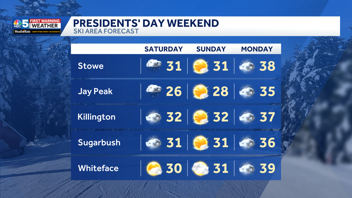
NBC5 meteorologists expect mostly quiet weather through Presidents’ Day weekend in Vermont and New York, with temperatures turning warmer by early next week.Ski Area Forecast BreakdownFriday Night into SaturdayA quick round of light snow is likely in New York Friday night, mostly west of the Tri-Lakes. Additional mountain snow showers are expected Saturday with some late clearing in far northern areas. Snow amounts are minor; only a couple inches along the Green Mountain spine and a more widespread dusting to 2 inches in the Adirondack Park. Slightly higher amounts are possible in southern St. Lawrence County.Sunday and MondaySunday will feature partly to mostly sunny skies with highs in the low-mid 30s. Easily the brightest day of the entire weekend!Clouds increase again on Monday, but a warmer south breeze will push temperatures close to 40 degrees by afternoon.Looking AheadMilder weather lasts into early next week before a pattern shift brings slightly cooler conditions, along with more opportunities for rain and snow.
NBC5 meteorologists expect mostly quiet weather through Presidents’ Day weekend in Vermont and New York, with temperatures turning warmer by early next week.
Ski Area Forecast Breakdown

NBC5 News
Forecast at several ski areas in Vermont and New York.

NBC5 News
Forecast at ski areas in Vermont and New York.
Friday Night into Saturday

Hearst Owned
The latest run of FutureCast.
A quick round of light snow is likely in New York Friday night, mostly west of the Tri-Lakes. Additional mountain snow showers are expected Saturday with some late clearing in far northern areas.

NBC5 News
Snowfall forecast Friday night through Saturday evening.
Snow amounts are minor; only a couple inches along the Green Mountain spine and a more widespread dusting to 2 inches in the Adirondack Park. Slightly higher amounts are possible in southern St. Lawrence County.
Sunday and Monday
Sunday will feature partly to mostly sunny skies with highs in the low-mid 30s. Easily the brightest day of the entire weekend!
Clouds increase again on Monday, but a warmer south breeze will push temperatures close to 40 degrees by afternoon.
Looking Ahead

Hearst Owned
Our latest extended forecast.
Milder weather lasts into early next week before a pattern shift brings slightly cooler conditions, along with more opportunities for rain and snow.