
NBC5 meteorologists are tracking a burst of snow on Friday that will be heavy at times, especially during the evening commute. TimingFriday morning is mostly dry with a few snow showers by daybreak in southern Vermont.By noon, the leading edge of steadier snow will arrive in the Tri-Lakes and central Vermont, overspreading northern spots entirely by sunset.Snowfall rates may surpass 1 inch per hour; too fast for plows to keep up with. Plan for snowy, slow-moving conditions for Friday evening’s commute.Steady snow gradually tapers to snow showers by early Saturday morning. The afternoon turns drier with some late sun possible north. Snow TotalsA widespread 4 to 8 inches of accumulation is expected Friday into Saturday morning. With temperatures close to freezing, this will be a wetter snow. Isolated power outages are possible due to wet snow loading on power lines/branches. Higher amounts over 8 inches are expected near the mountains where temperatures are colder. This includes Killington to Mad River Glen, into the eastern Adirondacks. This Weekend and BeyondQuieter conditions return this weekend. A coastal storm will need to be watched for Monday, but the latest model runs show a miss for us here.Want more local news? Download our NBC5 mobile app for iOS and Android.STAY WEATHER-AWAREFor the latest weather coverage for your area, click here. Stay updated with alerts in the myNBC5 app, which you can download here.For the best weather information and Vermont and northern New York’s Certified Most Accurate forecast, watch NBC5 News by streaming at this link.Don’t forget to follow NBC5 News on Facebook, X (formerly Twitter), and Instagram.Follow the NBC5 First Warning Weather team on social media:Chief Meteorologist Tyler Jankoski Facebook | X | InstagramMeteorologist Ben Frechette Facebook | X | InstagramMeteorologist Matt DiLoreto Facebook | XMeteorologist Andrew Grautski Facebook | XMeteorologist Marissa Vigevani Facebook | X
NBC5 meteorologists are tracking a burst of snow on Friday that will be heavy at times, especially during the evening commute.
Timing

Hearst Owned
The latest run of FutureCast.
Friday morning is mostly dry with a few snow showers by daybreak in southern Vermont.
By noon, the leading edge of steadier snow will arrive in the Tri-Lakes and central Vermont, overspreading northern spots entirely by sunset.
Snowfall rates may surpass 1 inch per hour; too fast for plows to keep up with. Plan for snowy, slow-moving conditions for Friday evening’s commute.
Steady snow gradually tapers to snow showers by early Saturday morning. The afternoon turns drier with some late sun possible north.
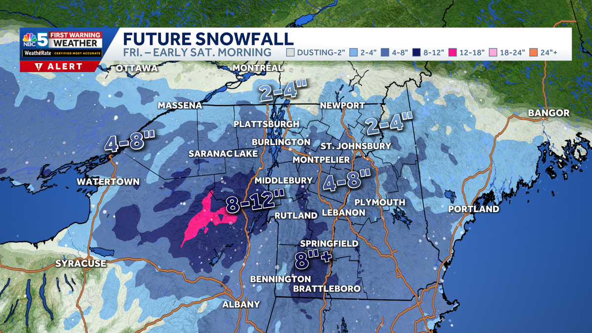
Snow Totals

NBC5 News
Snowfall forecast through Saturday morning.
A widespread 4 to 8 inches of accumulation is expected Friday into Saturday morning.
With temperatures close to freezing, this will be a wetter snow. Isolated power outages are possible due to wet snow loading on power lines/branches.
Higher amounts over 8 inches are expected near the mountains where temperatures are colder. This includes Killington to Mad River Glen, into the eastern Adirondacks.
This Weekend and Beyond

Hearst Owned
Our latest extended forecast.
Quieter conditions return this weekend. A coastal storm will need to be watched for Monday, but the latest model runs show a miss for us here.
Want more local news? Download our NBC5 mobile app for iOS and Android.
STAY WEATHER-AWARE
For the latest weather coverage for your area, click here. Stay updated with alerts in the myNBC5 app, which you can download here.
For the best weather information and Vermont and northern New York’s Certified Most Accurate forecast, watch NBC5 News by streaming at this link.
Don’t forget to follow NBC5 News on Facebook, X (formerly Twitter), and Instagram.
Follow the NBC5 First Warning Weather team on social media: